
| Memorials | : | 36 |
| Location | : | Leysdown, Swale Borough, England |
| Coordinate | : | 51.3970440, 0.9066620 |
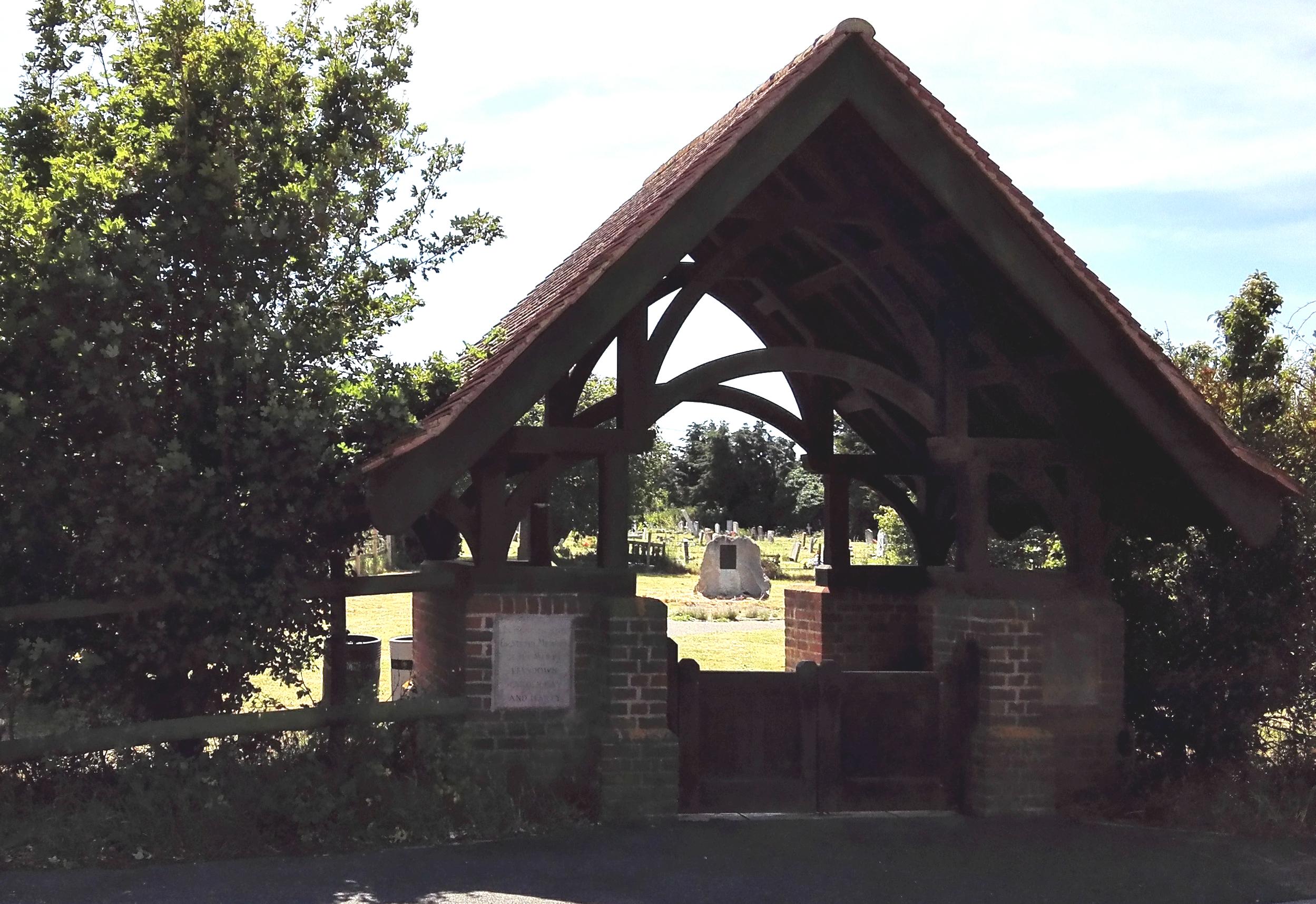
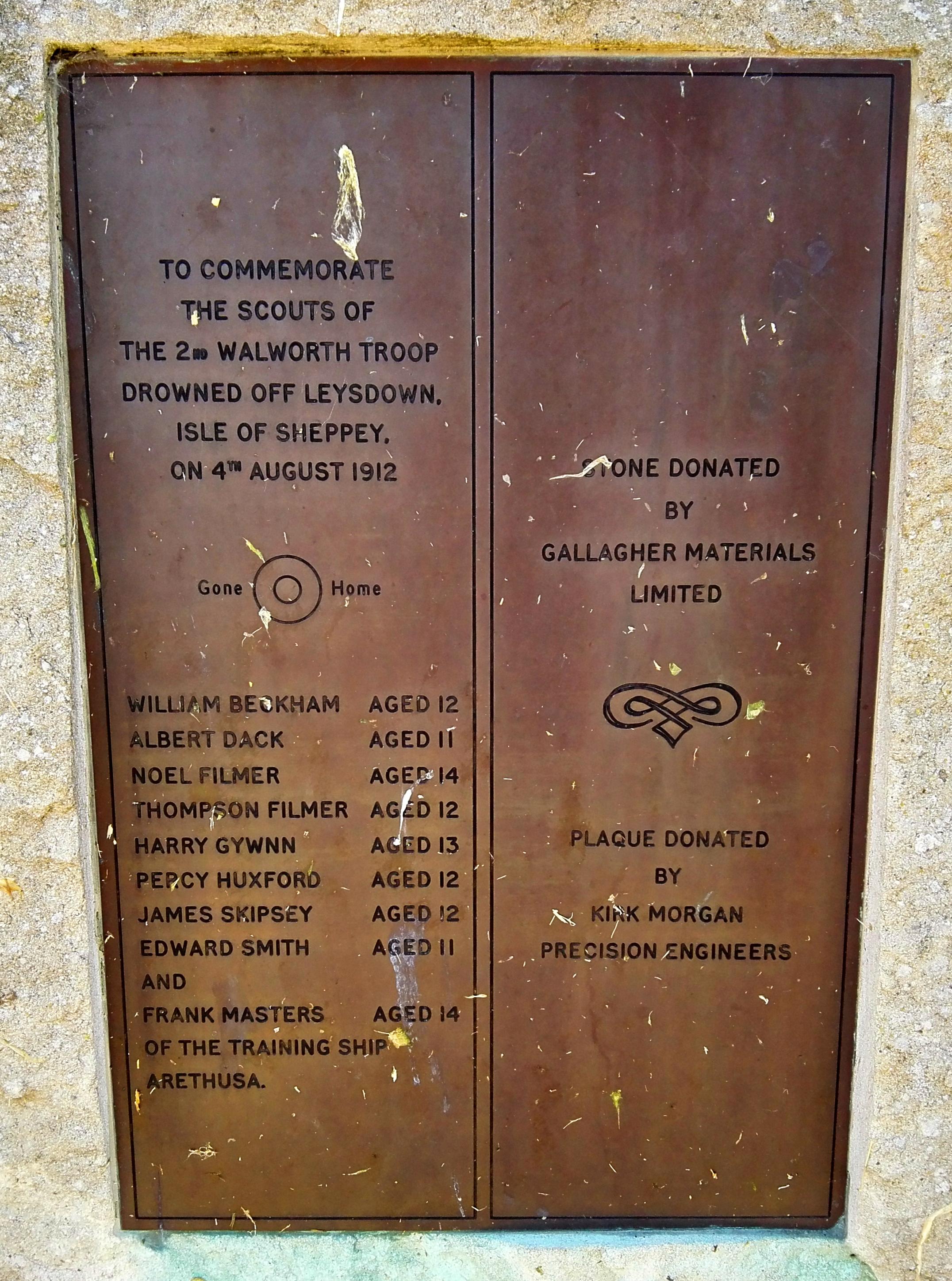
| Description | : | Leysdown is a coastal parish and village on the north-eastern side of Sheppey, six miles north-north-east of Faversham. On the outskirts of Leysdown is the church graveyard. It is all that remains of St Clements Church, which was demolished in the 1980s. There was a Royal Air Force aerodrome here. The churchyard contains war graves of both World Wars. The 1914-1918 burials are in a group north of the church. During the early months of the 1939-1945 War, ground adjoining this group was reserved by the authorities for service war graves and all save one of the burials were in... Read More |
frequently asked questions (FAQ):
-
Where is St Clement Churchyard?
St Clement Churchyard is located at Leysdown Road Leysdown, Swale Borough ,Kent , ME12 4EHEngland.
-
St Clement Churchyard cemetery's updated grave count on graveviews.com?
35 memorials
-
Where are the coordinates of the St Clement Churchyard?
Latitude: 51.3970440
Longitude: 0.9066620
Nearby Cemetories:
1. All Saints Churchyard
Eastchurch, Swale Borough, England
Coordinate: 51.4068909, 0.8574320
2. St Thomas the Apostle Churchyard
Harty, Swale Borough, England
Coordinate: 51.3598251, 0.9045590
3. Minster Abbey
Minster on Sea, Swale Borough, England
Coordinate: 51.4219320, 0.8119580
4. St Peter's Churchyard
Oare, Swale Borough, England
Coordinate: 51.3335910, 0.8804350
5. Ss Mary and Sexburga New Churchyard
Minster on Sea, Swale Borough, England
Coordinate: 51.4235540, 0.8098720
6. St Mary Churchyard
Luddenham, Swale Borough, England
Coordinate: 51.3324180, 0.8586720
7. All Saints Churchyard
Graveney, Swale Borough, England
Coordinate: 51.3261450, 0.9447880
8. Deerton Natural Burial Ground
Teynham, Swale Borough, England
Coordinate: 51.3344460, 0.8297850
9. St Mary Magdalene and St Lawrence Churchyard
Faversham, Swale Borough, England
Coordinate: 51.3193510, 0.8845170
10. St Mary Churchyard
Teynham, Swale Borough, England
Coordinate: 51.3377640, 0.8213570
11. St Mary of Charity Churchyard
Faversham, Swale Borough, England
Coordinate: 51.3171730, 0.8948480
12. Faversham Abbey (Defunct)
Faversham, Swale Borough, England
Coordinate: 51.3165680, 0.8958480
13. St. Alphege's Churchyard
Seasalter, City of Canterbury, England
Coordinate: 51.3432041, 1.0041740
14. St Bartholomew Churchyard
Goodnestone, Dover District, England
Coordinate: 51.3166220, 0.9322200
15. St Alphege Churchyard
Whitstable, City of Canterbury, England
Coordinate: 51.3576330, 1.0251080
16. Faversham Cemetery
Faversham, Swale Borough, England
Coordinate: 51.3110470, 0.9053170
17. St. Catherine's Churchyard
Faversham, Swale Borough, England
Coordinate: 51.3103390, 0.8926930
18. Sheppey Cemetery
Sheerness, Swale Borough, England
Coordinate: 51.4232780, 0.7718320
19. Whitstable Cemetery
Whitstable, City of Canterbury, England
Coordinate: 51.3529870, 1.0338530
20. All Saints Churchyard
Whitstable, City of Canterbury, England
Coordinate: 51.3558090, 1.0396670
21. St Peter and St Paul Churchyard
Ospringe, Swale Borough, England
Coordinate: 51.3070220, 0.8690570
22. St Michael Churchyard
Hernhill, Swale Borough, England
Coordinate: 51.3077430, 0.9612050
23. St Mary Churchyard
Norton, Swale Borough, England
Coordinate: 51.3149750, 0.8221900
24. St Giles Churchyard
Tonge, Swale Borough, England
Coordinate: 51.3424640, 0.7757790