
| Memorials | : | 147 |
| Location | : | London, City of London, England |
| Coordinate | : | 51.5096540, -0.0824830 |
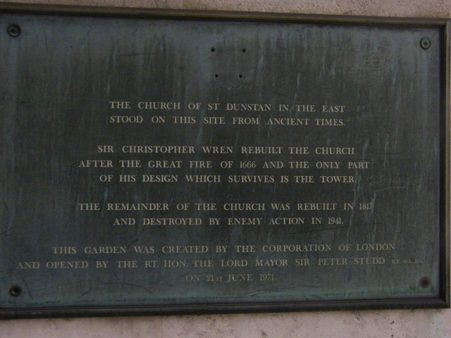
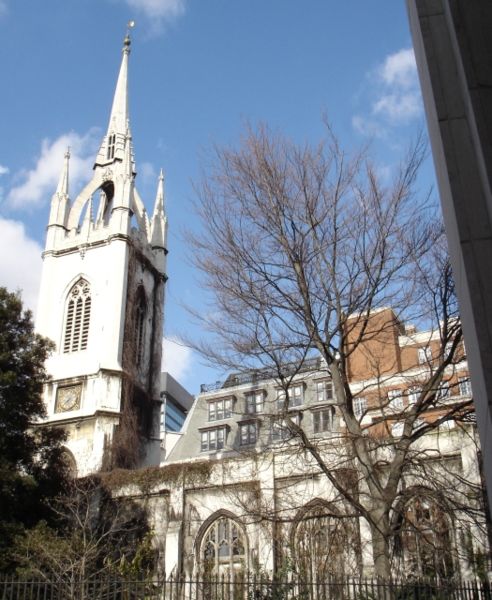
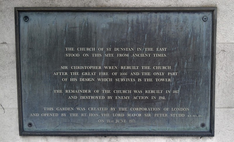
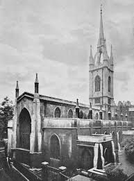
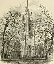
| Description | : | St. Dunstan-in-the-East was a Church of England Parish Church on St. Dunstan's Hill, halfway between London Bridge & the Tower of London in the City of London. The church was largely destroyed in the 2nd world war and the ruins are now a public garden. It was built about 1100. A new aisle was added in 1391 and the church was repaired in 1631 at a cost of £2,400. It was severely damaged in the Great Fire of London in 1666 and was patched up rather than being completely rebuilt between 1668-71. A steeple was added between 1695-1701 to the... Read More |
frequently asked questions (FAQ):
-
Where is St. Dunstan-in-the-East Churchyard?
St. Dunstan-in-the-East Churchyard is located at London, City of London ,Greater London , EC4England.
-
St. Dunstan-in-the-East Churchyard cemetery's updated grave count on graveviews.com?
147 memorials
-
Where are the coordinates of the St. Dunstan-in-the-East Churchyard?
Latitude: 51.5096540
Longitude: -0.0824830
Nearby Cemetories:
1. St. Mary-at-Hill Churchyard
Billingsgate, City of London, England
Coordinate: 51.5101050, -0.0836680
2. St Botolph Billingsgate Churchyard (Defunct)
London, City of London, England
Coordinate: 51.5096860, -0.0847310
3. St. George's Botolph Lane
Billingsgate, City of London, England
Coordinate: 51.5101840, -0.0847730
4. All Hallows by the Tower Churchyard
London, City of London, England
Coordinate: 51.5093600, -0.0794020
5. St. Leonard's Churchyard
Bridge, City of London, England
Coordinate: 51.5105870, -0.0855570
6. St Olave Hart Street Churchyard
London, City of London, England
Coordinate: 51.5108930, -0.0795990
7. Great Fire of London Monument
London, City of London, England
Coordinate: 51.5101100, -0.0859990
8. St. Benet's Churchyard
Bridge, City of London, England
Coordinate: 51.5115240, -0.0846030
9. All Hallows Staining Tower
London, City of London, England
Coordinate: 51.5115776, -0.0804890
10. St Mary Magdalene (Defunct)
London, City of London, England
Coordinate: 51.5100480, -0.0862540
11. St. Magnus the Martyr Churchyard
London, City of London, England
Coordinate: 51.5092500, -0.0862880
12. Church of the Crutched Friars
London, City of London, England
Coordinate: 51.5108000, -0.0785000
13. Tower Hill Memorial
London Borough of Tower Hamlets, England
Coordinate: 51.5096016, -0.0777000
14. St Michael Bassishaw Crooked Lane
London, City of London, England
Coordinate: 51.5107000, -0.0872800
15. St Clement's Eastcheap
London, City of London, England
Coordinate: 51.5114010, -0.0867810
16. All Hallows Lombard Street
London, City of London, England
Coordinate: 51.5123000, -0.0854000
17. St Martin Orgar Church
London, City of London, England
Coordinate: 51.5107520, -0.0875220
18. Chapel of Saint Peter-ad-Vincula
London Borough of Tower Hamlets, England
Coordinate: 51.5085335, -0.0769200
19. St. James Duke's Place Churchyard
Aldgate, City of London, England
Coordinate: 51.5128970, -0.0790280
20. St Laurence Pountney Churchyard
London, City of London, England
Coordinate: 51.5106100, -0.0885930
21. St Michael Cornhill Churchyard
London, City of London, England
Coordinate: 51.5131910, -0.0854760
22. All Hallows the Less
London, City of London, England
Coordinate: 51.5099000, -0.0893000
23. St Katherine Cree Churchyard
London, City of London, England
Coordinate: 51.5134315, -0.0791360
24. St Mary Woolnoth Churchyard
London, City of London, England
Coordinate: 51.5127650, -0.0881070