| Memorials | : | 149 |
| Location | : | Euston, London Borough of Camden, England |
| Coordinate | : | 51.5285950, -0.1378290 |
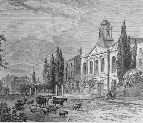
| Description | : | The burial ground belonged to the parish of St. James, Piccadilly, which obtained an Act of Parliament in 1788 for its formation, and provided for the erection of a chapel. A church was then built from the designs of Thomas Hardwick, a pupil of Sir William Chambers, and was consecrated in 1791. The ground was closed to burials and opened as a public garden in 1887. St James was one of several large inter-connected cemeteries in the district covering an area from Hampstead Road through what was St. James’ Garden, Euston Station and as far as St. Pancras. Under the... Read More |
frequently asked questions (FAQ):
-
Where is St. James' Chapel Burial Ground?
St. James' Chapel Burial Ground is located at Hampstead Road Euston, London Borough of Camden ,Greater London ,England.
-
St. James' Chapel Burial Ground cemetery's updated grave count on graveviews.com?
149 memorials
-
Where are the coordinates of the St. James' Chapel Burial Ground?
Latitude: 51.5285950
Longitude: -0.1378290
Nearby Cemetories:
1. University College London
Bloomsbury, City of Westminster, England
Coordinate: 51.5265200, -0.1310080
2. St Pancras New Church
St Pancras, London Borough of Camden, England
Coordinate: 51.5271730, -0.1300137
3. Danish Church of Saint Katharine
Camden Town, London Borough of Camden, England
Coordinate: 51.5337910, -0.1466700
4. St. Pancras Old Churchyard
St Pancras, London Borough of Camden, England
Coordinate: 51.5348960, -0.1302590
5. Whitefield’s Tabernacle and Burial Ground
London Borough of Camden, England
Coordinate: 51.5208990, -0.1350780
6. Kings Cross Underground Station
Kings Cross, London Borough of Camden, England
Coordinate: 51.5303960, -0.1238830
7. Kings Cross Station
Kings Cross, London Borough of Camden, England
Coordinate: 51.5304000, -0.1238800
8. St. Marylebone Churchyard
Marylebone, City of Westminster, England
Coordinate: 51.5224470, -0.1516930
9. St. George's Gardens
Bloomsbury, London Borough of Camden, England
Coordinate: 51.5259820, -0.1211810
10. The Foundling Hospital
Bloomsbury, London Borough of Camden, England
Coordinate: 51.5250140, -0.1201210
11. British Museum
London, City of London, England
Coordinate: 51.5190500, -0.1271778
12. St. George the Martyr Church
Holborn, London Borough of Camden, England
Coordinate: 51.5221490, -0.1221370
13. Great Ormond Street Hospital for Children
London, City of London, England
Coordinate: 51.5218890, -0.1206750
14. Mecklenburgh Square
Kings Cross, London Borough of Camden, England
Coordinate: 51.5251400, -0.1177600
15. St. Mary-le-bone and St. Georges Burying Ground
Marylebone, City of Westminster, England
Coordinate: 51.5206240, -0.1545440
16. St. George's Churchyard
Bloomsbury, City of Westminster, England
Coordinate: 51.5177160, -0.1248090
17. St. Andrew's Gardens
Kings Cross, London Borough of Camden, England
Coordinate: 51.5252090, -0.1161410
18. London Palladium
Soho, City of Westminster, England
Coordinate: 51.5146000, -0.1404500
19. St Giles in the Fields Churchyard
Holborn, London Borough of Camden, England
Coordinate: 51.5153070, -0.1285300
20. St. James Chapel Churchyard
Pentonville, London Borough of Islington, England
Coordinate: 51.5317590, -0.1148990
21. St. George Churchyard
Mayfair, City of Westminster, England
Coordinate: 51.5125140, -0.1429070
22. St Anne Churchyard
Soho, City of Westminster, England
Coordinate: 51.5123910, -0.1322610
23. St. Anne's Church
London, City of London, England
Coordinate: 51.5124321, -0.1318976
24. Sir John Soane's Museum
Holborn, London Borough of Camden, England
Coordinate: 51.5170370, -0.1174070


