| Memorials | : | 0 |
| Location | : | Pentonville, London Borough of Islington, England |
| Coordinate | : | 51.5317590, -0.1148990 |
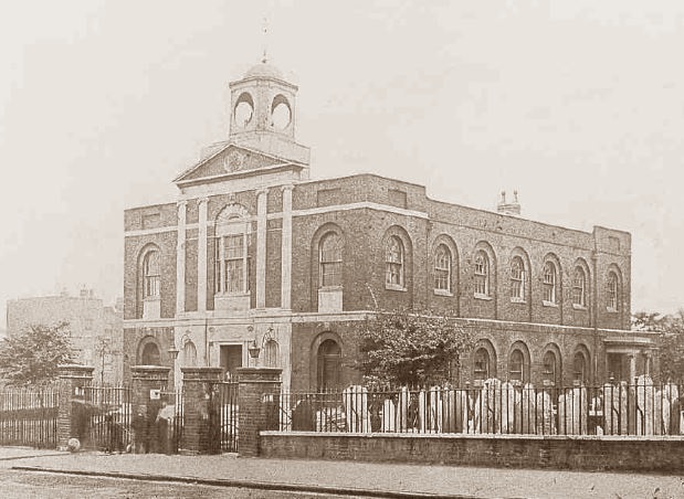
| Description | : | St. James's Church at Pentonville was a congregation of the Church of England with a churchyard cemetery. It is documented as being called St James' the Lesser. The St. James' Church, Pentonville was also called early its history as Pentonville Chapel or St James Chapel, Pentonville and it was used as a chapel to ease the nearby St. James' Church at Clerkenwell's congregation. The church was built from 1778 to 1792. This chapel opened in 1788 and was consecrated for use by the Church of England in 1791 and made a Parish in 1854. At... Read More |
frequently asked questions (FAQ):
-
Where is St. James Chapel Churchyard?
St. James Chapel Churchyard is located at Pentonville, London Borough of Islington ,Greater London ,England.
-
St. James Chapel Churchyard cemetery's updated grave count on graveviews.com?
0 memorials
-
Where are the coordinates of the St. James Chapel Churchyard?
Latitude: 51.5317590
Longitude: -0.1148990
Nearby Cemetories:
1. Kings Cross Station
Kings Cross, London Borough of Camden, England
Coordinate: 51.5304000, -0.1238800
2. Kings Cross Underground Station
Kings Cross, London Borough of Camden, England
Coordinate: 51.5303960, -0.1238830
3. St. Andrew's Gardens
Kings Cross, London Borough of Camden, England
Coordinate: 51.5252090, -0.1161410
4. Mecklenburgh Square
Kings Cross, London Borough of Camden, England
Coordinate: 51.5251400, -0.1177600
5. St. George's Gardens
Bloomsbury, London Borough of Camden, England
Coordinate: 51.5259820, -0.1211810
6. The Foundling Hospital
Bloomsbury, London Borough of Camden, England
Coordinate: 51.5250140, -0.1201210
7. St. James Churchyard
Clerkenwell, London Borough of Islington, England
Coordinate: 51.5235700, -0.1056500
8. St. Pancras Old Churchyard
St Pancras, London Borough of Camden, England
Coordinate: 51.5348960, -0.1302590
9. St Pancras New Church
St Pancras, London Borough of Camden, England
Coordinate: 51.5271730, -0.1300137
10. St. Mary's Churchyard
Islington, London Borough of Islington, England
Coordinate: 51.5384090, -0.1018950
11. Great Ormond Street Hospital for Children
London, City of London, England
Coordinate: 51.5218890, -0.1206750
12. St. George the Martyr Church
Holborn, London Borough of Camden, England
Coordinate: 51.5221490, -0.1221370
13. University College London
Bloomsbury, City of Westminster, England
Coordinate: 51.5265200, -0.1310080
14. The Order of St. John Cemetery
Farringdon, London Borough of Islington, England
Coordinate: 51.5231220, -0.1030110
15. St Clement with St Barnabas and St Matthew
Finsbury, London Borough of Islington, England
Coordinate: 51.5277700, -0.0977600
16. Plague Grave At Seward Street And Mount Mills
Clerkenwell, London Borough of Islington, England
Coordinate: 51.5259780, -0.0985880
17. Pentonville Prison Cemetery
Barnsbury, London Borough of Islington, England
Coordinate: 51.5455690, -0.1151720
18. Charterhouse
London Borough of Islington, England
Coordinate: 51.5213890, -0.0997220
19. St Luke Churchyard
St Luke's, London Borough of Islington, England
Coordinate: 51.5251312, -0.0941940
20. St. James' Chapel Burial Ground
Euston, London Borough of Camden, England
Coordinate: 51.5285950, -0.1378290
21. Charthouse Chapel and Churchyard
City of London, England
Coordinate: 51.5209310, -0.0987080
22. Sir John Soane's Museum
Holborn, London Borough of Camden, England
Coordinate: 51.5170370, -0.1174070
23. British Museum
London, City of London, England
Coordinate: 51.5190500, -0.1271778
24. St. George's Churchyard
Bloomsbury, City of Westminster, England
Coordinate: 51.5177160, -0.1248090


