
| Memorials | : | 1 |
| Location | : | Garway, Herefordshire Unitary Authority, England |
| Coordinate | : | 51.8982110, -2.7934460 |
frequently asked questions (FAQ):
-
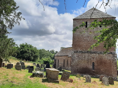
Where is St Michael churchyard?
St Michael churchyard is located at Garway, Herefordshire Unitary Authority ,Herefordshire , HR2 8RHEngland.
-
St Michael churchyard cemetery's updated grave count on graveviews.com?
1 memorials
-
Where are the coordinates of the St Michael churchyard?
Latitude: 51.8982110
Longitude: -2.7934460
Nearby Cemetories:
1. St Mary's Churchyard
Kentchurch, Herefordshire Unitary Authority, England
Coordinate: 51.9263169, -2.8456161
2. St. John the Baptist Churchyard
Llanwarne, Herefordshire Unitary Authority, England
Coordinate: 51.9501676, -2.7203512
3. Christ Church Cemetery
Llangarron, Herefordshire Unitary Authority, England
Coordinate: 51.8699460, -2.6889130
4. St. Mary & David Churchyard
Kilpeck, Herefordshire Unitary Authority, England
Coordinate: 51.9692310, -2.8076150
5. St. Michael and All Angels Churchyard
Ewyas Harold, Herefordshire Unitary Authority, England
Coordinate: 51.9539100, -2.8926070
6. Ewyas Harold Priory (Defunct)
Ewyas Harold, Herefordshire Unitary Authority, England
Coordinate: 51.9539100, -2.8969800
7. St. Dubricius Churchyard
Hentland, Herefordshire Unitary Authority, England
Coordinate: 51.9342080, -2.6660250
8. St. Swithin's Churchyard
Ganarew, Herefordshire Unitary Authority, England
Coordinate: 51.8433258, -2.6850994
9. Little Birch Churchyard
Little Birch, Herefordshire Unitary Authority, England
Coordinate: 51.9770250, -2.7126530
10. Holy Trinity and St Mary Churchyard
Abbey Dore, Herefordshire Unitary Authority, England
Coordinate: 51.9686570, -2.8936760
11. Hoarwithy Church of England
Hentland, Herefordshire Unitary Authority, England
Coordinate: 51.9612740, -2.6625310
12. Aconbury Hill
Aconbury, Herefordshire Unitary Authority, England
Coordinate: 51.9932540, -2.7212790
13. St. David's Churchyard
Little Dewchurch, Herefordshire Unitary Authority, England
Coordinate: 51.9822934, -2.6865234
14. St John The Baptist Churchyard
Kings Caple, Herefordshire Unitary Authority, England
Coordinate: 51.9562740, -2.6433720
15. Priory Churchyard
Aconbury, Herefordshire Unitary Authority, England
Coordinate: 51.9978900, -2.7052160
16. St Bridget Churchyard
Bridstow, Herefordshire Unitary Authority, England
Coordinate: 51.9204600, -2.6055410
17. All Saints Churchyard
Staunton (Coleford), Forest of Dean District, England
Coordinate: 51.8101900, -2.6533900
18. Church of St John of Jerusalem
Herefordshire Unitary Authority, England
Coordinate: 51.9914740, -2.6542940
19. St Mary Churchyard
English Bicknor, Forest of Dean District, England
Coordinate: 51.8390300, -2.6082000
20. All Saints Churchyard
Bishopswood, Herefordshire Unitary Authority, England
Coordinate: 51.8635318, -2.5852627
21. Christchurch Churchyard
Coleford, Forest of Dean District, England
Coordinate: 51.8135470, -2.6229980
22. St. Michael and All Angels Churchyard
Brampton Abbots, Herefordshire Unitary Authority, England
Coordinate: 51.9347980, -2.5817590
23. St Dubricius' Church
Ballingham, Herefordshire Unitary Authority, England
Coordinate: 51.9818590, -2.6186990
24. St Mary's Churchyard
Foy, Herefordshire Unitary Authority, England
Coordinate: 51.9520402, -2.5866687