
| Memorials | : | 1 |
| Location | : | Mamble, Malvern Hills District, England |
| Coordinate | : | 52.3416520, -2.4586520 |
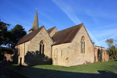
| Description | : | 13th century sandstone church |
frequently asked questions (FAQ):
-
Where is St John the Baptist Churchyard?
St John the Baptist Churchyard is located at Church Lane Mamble, Malvern Hills District ,Worcestershire , DY14 9JYEngland.
-
St John the Baptist Churchyard cemetery's updated grave count on graveviews.com?
1 memorials
-
Where are the coordinates of the St John the Baptist Churchyard?
Latitude: 52.3416520
Longitude: -2.4586520
Nearby Cemetories:
1. St Bartholomews Churchyard
Bayton, Malvern Hills District, England
Coordinate: 52.3562100, -2.4548200
2. St Lawrence Churchyard
Lindridge, Malvern Hills District, England
Coordinate: 52.3180700, -2.4779300
3. St Peter & St Paul Churchyard
Eastham, Malvern Hills District, England
Coordinate: 52.3156100, -2.5046000
4. St. Peter and St. Paul's Churchyard
Rock, Wyre Forest District, England
Coordinate: 52.3381020, -2.3955030
5. Saint James The Great Churchyard
Pensax, Malvern Hills District, England
Coordinate: 52.3181420, -2.4075720
6. St Mary the Virgin
Cleobury Mortimer, Shropshire Unitary Authority, England
Coordinate: 52.3792280, -2.4803610
7. Holy Trinity Churchyard
Far Forest, Wyre Forest District, England
Coordinate: 52.3730700, -2.4004200
8. Holy Trinity Churchyard
Kidderminster, Wyre Forest District, England
Coordinate: 52.3727940, -2.3999840
9. St Michael & All Angels Churchyard
Knighton-on-Teme, Malvern Hills District, England
Coordinate: 52.3260900, -2.5393500
10. Neen Savage
Cleobury Mortimer, Shropshire Unitary Authority, England
Coordinate: 52.3930000, -2.4799400
11. St. Mary's Churchyard
Stanford-on-Teme, Malvern Hills District, England
Coordinate: 52.2887100, -2.4379200
12. St Michael and All Angels Churchyard
Rochford, Malvern Hills District, England
Coordinate: 52.3134240, -2.5454090
13. St. Michael & All Angels Churchyard
Hopton Wafers, Shropshire Unitary Authority, England
Coordinate: 52.3857100, -2.5343700
14. St. Mary's Churchyard
Abberley, Malvern Hills District, England
Coordinate: 52.3095380, -2.3656130
15. St. Michael's Churchyard
Abberley, Malvern Hills District, England
Coordinate: 52.3083500, -2.3628600
16. St. Peter's Churchyard
Coreley, Shropshire Unitary Authority, England
Coordinate: 52.3627780, -2.5694950
17. St Giles Churchyard
Heightington, Wyre Forest District, England
Coordinate: 52.3380600, -2.3425800
18. Hopton Bank Methodist Church Burial Ground
Hopton Wafers, Shropshire Unitary Authority, England
Coordinate: 52.3872950, -2.5584430
19. St. John the Baptist Churchyard
Doddington, Cheshire East Unitary Authority, England
Coordinate: 52.3822068, -2.5651644
20. Great Witley Chapel Churchyard
Great Witley, Malvern Hills District, England
Coordinate: 52.2887620, -2.3547810
21. St. Andrew's Churchyard
Shelsley Walsh, Malvern Hills District, England
Coordinate: 52.2641700, -2.4093500
22. St. Peter's Churchyard
Stoke Bliss, Malvern Hills District, England
Coordinate: 52.2627200, -2.5121300
23. St. John the Baptist Churchyard
Kinlet, Shropshire Unitary Authority, England
Coordinate: 52.4265270, -2.4270270
24. All Saints Churchyard Extension
Shelsley Beauchamp, Malvern Hills District, England
Coordinate: 52.2634662, -2.3949512