
| Memorials | : | 0 |
| Location | : | Wolvey, Rugby Borough, England |
| Coordinate | : | 52.4880490, -1.3671940 |
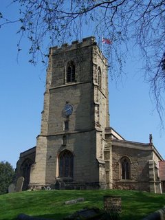
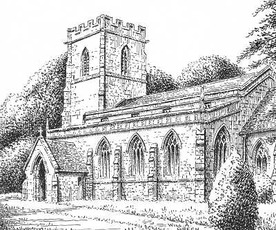
| Description | : | Saint John the Baptist Churchyard, Wolvey, Warwickshire, England WOLVEY, a parish in the hundred of Knightlow, county Warwick, 8 miles N.E. of Coventry, 6 S.E. of Nuneaton, and 4 from Hinckley. The village, which is partly inhabited by ribbon weavers, is situated near the river Anker. The parish includes the hamlets of Bramcott, Copson, and Smokington, which last was formerly a considerable village on the line of the ancient Watling Street. On Wolvey Heath was a hermitage, founded in the reign of Richard II., and here Edward IV. was surprised by the Earl of Warwick, who conveyed him hence to... Read More |
frequently asked questions (FAQ):
-
Where is St John the Baptist Churchyard?
St John the Baptist Churchyard is located at School Lane Wolvey, Rugby Borough ,Warwickshire , LE10 3LHEngland.
-
St John the Baptist Churchyard cemetery's updated grave count on graveviews.com?
0 memorials
-
Where are the coordinates of the St John the Baptist Churchyard?
Latitude: 52.4880490
Longitude: -1.3671940
Nearby Cemetories:
1. Wolvey Baptist Churchyard
Wolvey, Rugby Borough, England
Coordinate: 52.4870250, -1.3670310
2. Wolvey Cemetery
Wolvey, Rugby Borough, England
Coordinate: 52.4869130, -1.3642870
3. St John's Churchyard
Copston Magna, Rugby Borough, England
Coordinate: 52.4918680, -1.3354700
4. St. Botolph Churchyard
Burton Hastings, Rugby Borough, England
Coordinate: 52.5055000, -1.3976000
5. All Saints Churchyard
Withybrook, Rugby Borough, England
Coordinate: 52.4574170, -1.3626220
6. St James Churchyard
Bulkington, Nuneaton and Bedworth Borough, England
Coordinate: 52.4773830, -1.4256900
7. Shilton Cemetery
Shilton, Rugby Borough, England
Coordinate: 52.4560640, -1.4076450
8. St Andrew's Churchyard
Shilton, Rugby Borough, England
Coordinate: 52.4556900, -1.4071560
9. Our Lady of the Sacred Heart Catholic Church
Bulkington, Nuneaton and Bedworth Borough, England
Coordinate: 52.4816820, -1.4341200
10. St Catherine's Churchyard
Burbage, Hinckley and Bosworth Borough, England
Coordinate: 52.5309330, -1.3483010
11. Burbage Cemetery
Burbage, Hinckley and Bosworth Borough, England
Coordinate: 52.5278950, -1.3347280
12. Saint James Parish Churchyard
Ansty, Rugby Borough, England
Coordinate: 52.4498190, -1.4132490
13. Barnacle Chapel Churchyard
Rugby Borough, England
Coordinate: 52.4590430, -1.4350380
14. St Peter's Church
Aston Flamville, Blaby District, England
Coordinate: 52.5307260, -1.3187510
15. St Edith's Churchyard
Monks Kirby, Rugby Borough, England
Coordinate: 52.4444360, -1.3195900
16. St Joseph's Roman Catholic Cemetery
Monks Kirby, Rugby Borough, England
Coordinate: 52.4479540, -1.3111280
17. St Marys Parish Churchyard
Hinckley, Hinckley and Bosworth Borough, England
Coordinate: 52.5407970, -1.3721560
18. St. Edith Churchyard
Monks Kirby, Rugby Borough, England
Coordinate: 52.4439800, -1.3192500
19. Heart of England Crematorium
Nuneaton, Nuneaton and Bedworth Borough, England
Coordinate: 52.5182420, -1.4425920
20. Attleborough Cemetery
Attleborough, Nuneaton and Bedworth Borough, England
Coordinate: 52.5116943, -1.4494337
21. Claybrooke Cemetery
Claybrooke Parva, Harborough District, England
Coordinate: 52.4862230, -1.2724990
22. St. Peter's Churchyard
Claybrooke Parva, Harborough District, England
Coordinate: 52.4868640, -1.2708550
23. St Helen
Sharnford, Blaby District, England
Coordinate: 52.5228440, -1.2886350
24. Holy Trinity Churchyard
Attleborough, Nuneaton and Bedworth Borough, England
Coordinate: 52.5144020, -1.4563310