
| Memorials | : | 0 |
| Location | : | Caterham, Tandridge District, England |
| Website | : | www.countyasylums.co.uk/caterham-mental-hospital/ |
| Coordinate | : | 51.2878640, -0.1079560 |
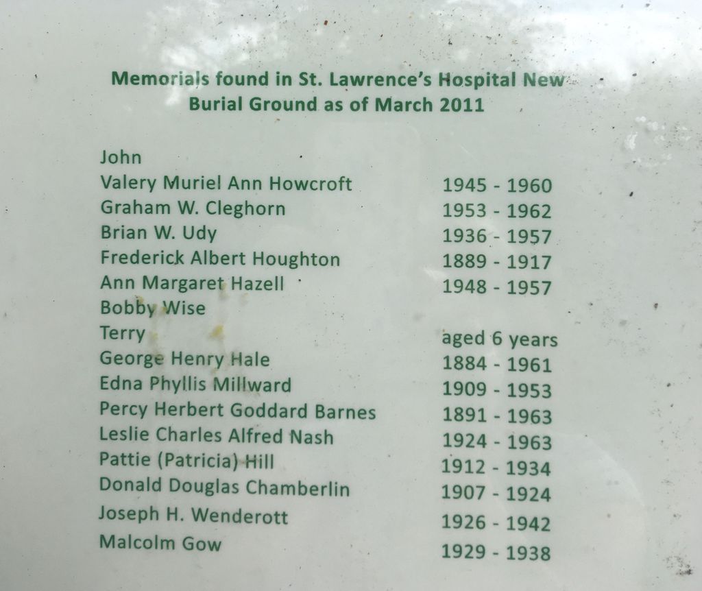
| Description | : | Previous Names: Metropolitan District Asylum, Metropolitan Imbecile Asylum, Caterham Asylum, Caterham Mental Hospital St. Lawrence Hospital opened in 1870 and was constructed by the architectural firm of John Giles and Biven. The burial ground for was located at corner of Chaldon Road and Green lane. Between 1916 and 1965 thousands of patients from the hospital were buried here. A burial register for 1916-1948 records 3,100 people buried in 276 plots with 10-15 bodies in each grave. Sixteen headstones including two angels marking the graves of children have been preserved towards the edges of the site and it has been... Read More |
frequently asked questions (FAQ):
-
Where is St. Lawrence's Hospital Burial Ground?
St. Lawrence's Hospital Burial Ground is located at Coulsdon Road Caterham, Tandridge District ,Surrey ,England.
-
St. Lawrence's Hospital Burial Ground cemetery's updated grave count on graveviews.com?
0 memorials
-
Where are the coordinates of the St. Lawrence's Hospital Burial Ground?
Latitude: 51.2878640
Longitude: -0.1079560
Nearby Cemetories:
1. Chaldon Saint Peter and Saint Paul Churchyard
Whyteleafe, Tandridge District, England
Coordinate: 51.2852778, -0.1248302
2. St Lawrence Church
Caterham, Tandridge District, England
Coordinate: 51.2820880, -0.0858740
3. St. Mary the Virgin Churchyard
Caterham, Tandridge District, England
Coordinate: 51.2821440, -0.0856350
4. Caterham Cemetery
Caterham, Tandridge District, England
Coordinate: 51.2824240, -0.0846160
5. St Luke Churchyard
Whyteleafe, Tandridge District, England
Coordinate: 51.3079740, -0.0827840
6. St. Margaret's Churchyard
Hooley, Reigate and Banstead Borough, England
Coordinate: 51.2923980, -0.1602950
7. St Katharine's Churchyard
Merstham, Reigate and Banstead Borough, England
Coordinate: 51.2689900, -0.1514700
8. Convent of the Sacred Heart Cemetery
Woldingham, Tandridge District, England
Coordinate: 51.2755490, -0.0508110
9. All Saints Churchyard
Warlingham, Tandridge District, England
Coordinate: 51.3133408, -0.0557738
10. St James' Church Riddlesdown
Caterham, Tandridge District, England
Coordinate: 51.3302800, -0.1075140
11. St Mary Churchyard
Bletchingley, Tandridge District, England
Coordinate: 51.2413460, -0.0994430
12. St. Agatha Churchyard
Woldingham, Tandridge District, England
Coordinate: 51.2771930, -0.0350300
13. St Peter and St Paul Churchyard
Nutfield, Tandridge District, England
Coordinate: 51.2419780, -0.1258540
14. Greenlawn Memorial Park
Warlingham, Tandridge District, England
Coordinate: 51.3079900, -0.0395000
15. Bletchingley Cemetery
Bletchingley, Tandridge District, England
Coordinate: 51.2411080, -0.0911120
16. Saint Nicholas Churchyard
Godstone, Tandridge District, England
Coordinate: 51.2465740, -0.0567650
17. St Peter's Churchyard
Woodmansterne, Reigate and Banstead Borough, England
Coordinate: 51.3246900, -0.1693300
18. St Marys Churchyard
Farleigh, Tandridge District, England
Coordinate: 51.3233709, -0.0320591
19. St Peter Churchyard
Tandridge, Tandridge District, England
Coordinate: 51.2429480, -0.0320950
20. Redstone Cemetery
Redhill, Reigate and Banstead Borough, England
Coordinate: 51.2310910, -0.1601330
21. St. Leonard's Churchyard
Chelsham, Tandridge District, England
Coordinate: 51.3134100, -0.0083000
22. All Saints Churchyard
Banstead, Reigate and Banstead Borough, England
Coordinate: 51.3220583, -0.2008833
23. St Mary the Virgin Churchyard
Oxted, Tandridge District, England
Coordinate: 51.2590680, -0.0086690
24. Banstead Hospital Cemetery
Banstead, Reigate and Banstead Borough, England
Coordinate: 51.3389400, -0.1849100