
| Memorials | : | 1 |
| Location | : | Alderwasley, Amber Valley Borough, England |
| Coordinate | : | 53.0769800, -1.5180550 |
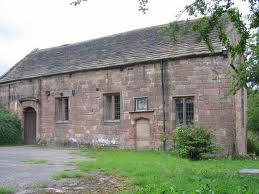
| Description | : | The chapel, dedicated to St. Margaret, is Alderwasley's oldest structure and was built in the early sixteenth century (during the reign of King Henry VIII) by Thomas Lowe, then Lord of the Manor. It was the local place of worship until All Saints Church was built c1850. This Chapel had a graveyard. Note: any church within an urban environment may have had its graveyard closed after the Burial Act of 1853. Any new church built after that is unlikely to have had a graveyard at all. Church History: This Chapel was founded in the 16th century, it was closed in 1849. St Margaret's Church is... Read More |
frequently asked questions (FAQ):
-
Where is St. Margaret's Chapel?
St. Margaret's Chapel is located at Chapel Lane, Alderwasley, Amber Valley Borough ,Derbyshire ,England.
-
St. Margaret's Chapel cemetery's updated grave count on graveviews.com?
1 memorials
-
Where are the coordinates of the St. Margaret's Chapel?
Latitude: 53.0769800
Longitude: -1.5180550

Nearby Cemetories:
1. Alderwasley cemetery
Alderwasley, Amber Valley Borough, England
Coordinate: 53.0767150, -1.5186900
2. Saint Mary's Churchyard
Crich, Amber Valley Borough, England
Coordinate: 53.0880100, -1.4819100
3. Dethick Lea and Holloway Cemetery
Holloway, Amber Valley Borough, England
Coordinate: 53.1075100, -1.5183800
4. Wirksworth Baptist Burial Ground
Wirksworth, Derbyshire Dales District, England
Coordinate: 53.0848778, -1.5709972
5. Wirksworth Cemetery
Wirksworth, Derbyshire Dales District, England
Coordinate: 53.0856224, -1.5709003
6. St. Mary's Church Vaults
Wirksworth, Derbyshire Dales District, England
Coordinate: 53.0819830, -1.5723380
7. St. Mary's Churchyard
Wirksworth, Derbyshire Dales District, England
Coordinate: 53.0819830, -1.5723380
8. Steeple Arch Cemetery
Wirksworth, Derbyshire Dales District, England
Coordinate: 53.0969820, -1.5688340
9. St. Mary's Churchyard
Cromford, Derbyshire Dales District, England
Coordinate: 53.1104260, -1.5538440
10. St. Mark's Churchyard
Cromford, Derbyshire Dales District, England
Coordinate: 53.1076550, -1.5647150
11. Wingfield Park
South Wingfield, Amber Valley Borough, England
Coordinate: 53.0800910, -1.4450070
12. Holy Trinity Churchyard
Middleton by Wirksworth, Derbyshire Dales District, England
Coordinate: 53.0979228, -1.5860175
13. Belper Cemetery
Belper, Amber Valley Borough, England
Coordinate: 53.0370590, -1.4793930
14. Holy Trinity Churchyard
Matlock Bath, Derbyshire Dales District, England
Coordinate: 53.1172020, -1.5612230
15. St Luke's Heage
Belper, Amber Valley Borough, England
Coordinate: 53.0516040, -1.4501580
16. St Luke Churchyard
Heage, Amber Valley Borough, England
Coordinate: 53.0516130, -1.4500690
17. St. Luke's Churchyard
Heage, Amber Valley Borough, England
Coordinate: 53.0516000, -1.4500700
18. Middleton by Wirksworth Cemetery
Middleton by Wirksworth, Derbyshire Dales District, England
Coordinate: 53.1033860, -1.5919920
19. St. James' Churchyard
Idridgehay, Amber Valley Borough, England
Coordinate: 53.0377540, -1.5756560
20. Holy Trinity Churchyard
Kirk Ireton, Derbyshire Dales District, England
Coordinate: 53.0485040, -1.6002000
21. All Saints Churchyard
South Wingfield, Amber Valley Borough, England
Coordinate: 53.0977640, -1.4291210
22. St. James the Apostle Churchyard
Bonsall, Derbyshire Dales District, England
Coordinate: 53.1196200, -1.5832110
23. Holy Trinity Churchyard
Tansley, Derbyshire Dales District, England
Coordinate: 53.1353920, -1.5194670
24. St. John's Chapel Cemetery
Belper, Amber Valley Borough, England
Coordinate: 53.0239651, -1.4759286