| Memorials | : | 0 |
| Location | : | Southwark, London Borough of Southwark, England |
| Coordinate | : | 51.5044900, -0.0907270 |
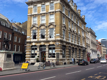
| Description | : | Parish church of Southwark until 1541. The burial ground was extended in 1536 and the site of church sold in 1545. The church converted to a prison in later years, then replaced by the town hall. The ground being disturbed during building work in 1832 revealed large quantities of human remains. The site is now occupied by Town Hall Chambers. |
frequently asked questions (FAQ):
-
Where is St. Margaret Churchyard?
St. Margaret Churchyard is located at Southwark, London Borough of Southwark, Greater London, England Southwark, London Borough of Southwark ,Greater London ,England.
-
St. Margaret Churchyard cemetery's updated grave count on graveviews.com?
0 memorials
-
Where are the coordinates of the St. Margaret Churchyard?
Latitude: 51.5044900
Longitude: -0.0907270
Nearby Cemetories:
1. St. Saviour's Almshouses Cemetery
Southwark, London Borough of Southwark, England
Coordinate: 51.5051460, -0.0914880
2. Colliers Rents Congregational Chapel
Southwark, London Borough of Southwark, England
Coordinate: 51.5042800, -0.0890700
3. Crossbones Cemetery
Southwark, London Borough of Southwark, England
Coordinate: 51.5041500, -0.0933730
4. Southwark Cathedral
Southwark, London Borough of Southwark, England
Coordinate: 51.5061417, -0.0895970
5. Deadman's Place Burial Ground
Southwark, London Borough of Southwark, England
Coordinate: 51.5056040, -0.0944280
6. Maze Pond Baptist Chapel Burial Ground
Southwark, London Borough of Southwark, England
Coordinate: 51.5034850, -0.0862760
7. St George the Martyr Churchyard
Southwark, London Borough of Southwark, England
Coordinate: 51.5012000, -0.0926700
8. Guy's Hospital Chapel and Burial Ground
Southwark, London Borough of Southwark, England
Coordinate: 51.5016230, -0.0863980
9. Baptist Chapel Burial Ground
Southwark, London Borough of Southwark, England
Coordinate: 51.5027900, -0.0978580
10. Ewer Street Burial Ground
Southwark, London Borough of Southwark, England
Coordinate: 51.5045560, -0.0990240
11. All Hallows the Less
London, City of London, England
Coordinate: 51.5099000, -0.0893000
12. All Hallows the Great
London, City of London, England
Coordinate: 51.5099720, -0.0900440
13. St. Magnus the Martyr Churchyard
London, City of London, England
Coordinate: 51.5092500, -0.0862880
14. St Mary Magdalene (Defunct)
London, City of London, England
Coordinate: 51.5100480, -0.0862540
15. St Laurence Pountney Churchyard
London, City of London, England
Coordinate: 51.5106100, -0.0885930
16. Great Fire of London Monument
London, City of London, England
Coordinate: 51.5101100, -0.0859990
17. St Botolph Billingsgate Churchyard (Defunct)
London, City of London, England
Coordinate: 51.5096860, -0.0847310
18. St Michael Bassishaw Crooked Lane
London, City of London, England
Coordinate: 51.5107000, -0.0872800
19. St Martin Orgar Church
London, City of London, England
Coordinate: 51.5107520, -0.0875220
20. St. George's Botolph Lane
Billingsgate, City of London, England
Coordinate: 51.5101840, -0.0847730
21. St James Garlickhythe Churchyard
London, City of London, England
Coordinate: 51.5111070, -0.0937560
22. St. Leonard's Churchyard
Bridge, City of London, England
Coordinate: 51.5105870, -0.0855570
23. Saint Mary Bothaw (Defunct)
London, City of London, England
Coordinate: 51.5114000, -0.0900800
24. St. Mary-at-Hill Churchyard
Billingsgate, City of London, England
Coordinate: 51.5101050, -0.0836680

