
| Memorials | : | 3 |
| Location | : | Harwood Dale, Scarborough Borough, England |
| Coordinate | : | 54.3558170, -0.5365790 |
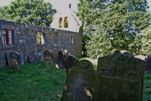
| Description | : | Saint Margaret Church, and adjoining cemetery, were abandoned in 1862 when a new church was built a mile away. The ruins are in a walled enclosure on a hilltop approximately 150m south of Chapel Farm. The church and cemetery are located within the bounds of North York Moors National Park. Information from: HistoricEngland.org.uk, listing # 1021265 FamilySearch Images contains a 1950s transcript containing 55 interments. |
frequently asked questions (FAQ):
-
Where is St Margaret Churchyard (Ruins)?
St Margaret Churchyard (Ruins) is located at Harwood Dale, Scarborough Borough ,North Yorkshire ,England.
-
St Margaret Churchyard (Ruins) cemetery's updated grave count on graveviews.com?
2 memorials
-
Where are the coordinates of the St Margaret Churchyard (Ruins)?
Latitude: 54.3558170
Longitude: -0.5365790
Nearby Cemetories:
1. St Margaret Churchyard
Harwood Dale, Scarborough Borough, England
Coordinate: 54.3470030, -0.5238540
2. Staintondale Churchyard
Staintondale, Scarborough Borough, England
Coordinate: 54.3752645, -0.4795295
3. St Hilda Churchyard
Ravenscar, Scarborough Borough, England
Coordinate: 54.3973500, -0.4925300
4. St Peter Churchyard
Langdale End, Scarborough Borough, England
Coordinate: 54.3065050, -0.5557030
5. Cloughton Church Cemetery
Cloughton, Scarborough Borough, England
Coordinate: 54.3322500, -0.4511900
6. St Peter Churchyard
Hackness, Scarborough Borough, England
Coordinate: 54.3012880, -0.5127850
7. Ebenezers Baptist Church
Scarborough Borough, England
Coordinate: 54.3744655, -0.6557164
8. St Laurence Churchyard
Scalby, Scarborough Borough, England
Coordinate: 54.2988160, -0.4507520
9. St. Stephen's New Churchyard
Robin Hoods Bay, Scarborough Borough, England
Coordinate: 54.4341460, -0.5394280
10. St. Stephen Old Churchyard
Fylingdales, Scarborough Borough, England
Coordinate: 54.4400890, -0.5496350
11. Woodlands Cemetery and Crematorium
Scarborough, Scarborough Borough, England
Coordinate: 54.2766640, -0.4428030
12. Dean Road and Manor Road Cemetery
Scarborough, Scarborough Borough, England
Coordinate: 54.2843690, -0.4184140
13. St. Mary's Churchyard
Scarborough, Scarborough Borough, England
Coordinate: 54.2864850, -0.3936260
14. Greyfriars Abbey
Scarborough, Scarborough Borough, England
Coordinate: 54.2850360, -0.3950300
15. All Saints Churchyard
High Hawsker, Scarborough Borough, England
Coordinate: 54.4624580, -0.5785000
16. Quaker House Church
Scarborough Borough, England
Coordinate: 54.2844280, -0.3941730
17. Scarborough Castle
Scarborough, Scarborough Borough, England
Coordinate: 54.2875810, -0.3895485
18. St. John the Baptist Churchyard
East Ayton, Scarborough Borough, England
Coordinate: 54.2508900, -0.4792900
19. Lockton Cemetery
Lockton, Ryedale District, England
Coordinate: 54.2977400, -0.7003200
20. St. Hilda's Churchyard
Sneaton, Scarborough Borough, England
Coordinate: 54.4579490, -0.6226930
21. St Giles Churchyard
Lockton, Ryedale District, England
Coordinate: 54.2987100, -0.7057700
22. St Matthew Churchyard
Hutton Buscel, Scarborough Borough, England
Coordinate: 54.2426410, -0.5071200
23. All Saints Churchyard
Ugglebarnby, Scarborough Borough, England
Coordinate: 54.4522340, -0.6446610
24. St Mary Churchyard
Goathland, Scarborough Borough, England
Coordinate: 54.3950300, -0.7266400