
| Memorials | : | 0 |
| Location | : | Wythall, Bromsgrove District, England |
| Coordinate | : | 52.3720200, -1.8940700 |
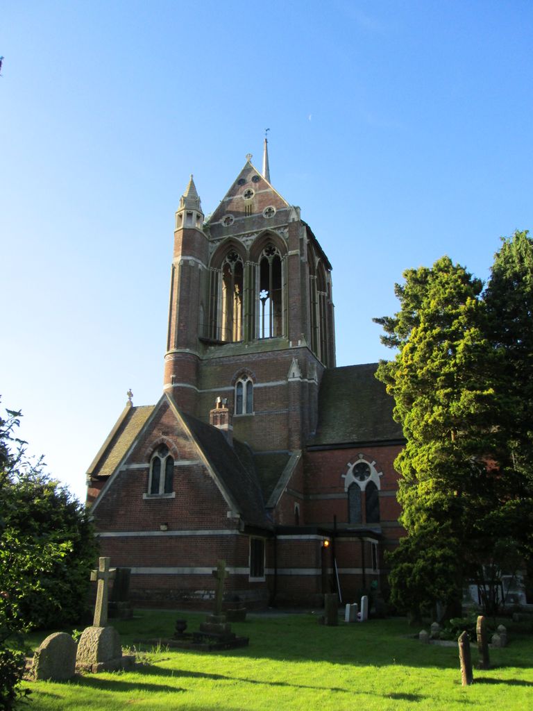
| Description | : | Sadly, St. Mary's Church was closed for worship in 1987, because it was found to be structurally unsafe. Location: Intersection of Chapel Lane and Severn Way, Wythall. |
frequently asked questions (FAQ):
-
Where is St. Mary's Churchyard?
St. Mary's Churchyard is located at Chapel Lane, Wythall, Bromsgrove District ,Worcestershire ,England.
-
St. Mary's Churchyard cemetery's updated grave count on graveviews.com?
0 memorials
-
Where are the coordinates of the St. Mary's Churchyard?
Latitude: 52.3720200
Longitude: -1.8940700
Nearby Cemetories:
1. Wythall Cemetery
Wythall, Bromsgrove District, England
Coordinate: 52.3745100, -1.8908450
2. Kingswood Chapel Graveyard
Hollywood, Bromsgrove District, England
Coordinate: 52.3913600, -1.8872000
3. Kings Norton Cemetery
Kings Norton, Metropolitan Borough of Birmingham, England
Coordinate: 52.3984090, -1.9220470
4. Saint Nicolas Churchyard
Kings Norton, Metropolitan Borough of Birmingham, England
Coordinate: 52.4086480, -1.9289630
5. St. Patrick's Church
Tanworth-in-Arden, Stratford-on-Avon District, England
Coordinate: 52.3719300, -1.8214200
6. St. Patrick's Cemetery
Solihull, Metropolitan Borough of Solihull, England
Coordinate: 52.3718820, -1.8213030
7. Christ Church Churchyard
Yardley Wood, Metropolitan Borough of Birmingham, England
Coordinate: 52.4128140, -1.8645350
8. Brandwood End Cemetery
Birmingham, Metropolitan Borough of Birmingham, England
Coordinate: 52.4181900, -1.8991100
9. St Laurence Churchyard
Alvechurch, Bromsgrove District, England
Coordinate: 52.3500430, -1.9624850
10. St. Leonard's Churchyard
Beoley, Bromsgrove District, England
Coordinate: 52.3249100, -1.9058000
11. St Mary Magdalene Churchyard
Tanworth-in-Arden, Stratford-on-Avon District, England
Coordinate: 52.3325500, -1.8350020
12. Our Lady of Lourdes
Yardley Wood, Metropolitan Borough of Birmingham, England
Coordinate: 52.4221570, -1.8605590
13. St James the Great Churchyard
Shirley, Metropolitan Borough of Solihull, England
Coordinate: 52.4072050, -1.8257760
14. St. Michael's Churchyard
Cofton Hackett, Bromsgrove District, England
Coordinate: 52.3762190, -1.9840740
15. St Laurence Churchyard Extension
Northfield, Metropolitan Borough of Birmingham, England
Coordinate: 52.4121060, -1.9641390
16. All Saints Churchyard
Kings Heath, Metropolitan Borough of Birmingham, England
Coordinate: 52.4330710, -1.8937240
17. Abbey Cemetery
Redditch, Redditch Borough, England
Coordinate: 52.3168400, -1.9388000
18. Reddidth Crematorium
Redditch, Redditch Borough, England
Coordinate: 52.3166750, -1.9385110
19. Robin Hood Cemetery and Crematorium
Solihull, Metropolitan Borough of Solihull, England
Coordinate: 52.4206910, -1.8210050
20. Oratory Retreat Cemetery
Rednal, Metropolitan Borough of Birmingham, England
Coordinate: 52.3848240, -2.0046110
21. Sisters of Charity of St Paul the Apostle Convent
Birmingham, Metropolitan Borough of Birmingham, England
Coordinate: 52.4393400, -1.9205200
22. St. Paul's Convent Cemetery
Birmingham, Metropolitan Borough of Birmingham, England
Coordinate: 52.4401580, -1.9217800
23. Church of The Ascension
Hall Green, Metropolitan Borough of Birmingham, England
Coordinate: 52.4341000, -1.8398200
24. Holy Trinity Churchyard
Lickey, Bromsgrove District, England
Coordinate: 52.3751560, -2.0094860