
| Memorials | : | 214 |
| Location | : | Warthill, Ryedale District, England |
| Coordinate | : | 53.9887610, -0.9714450 |
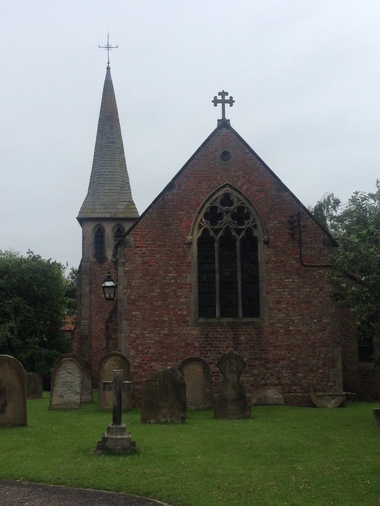
| Description | : | The church of ST. MARY is a small modern building consisting of a chancel, nave and tower on the south side, forming a porch. The ancient church was pulled down in 1787 and a brick building substituted by Robert Bowes. The present structure was begun in 1873 and is of red brick with stone dressings. The tower is surmounted by a small slate spire and contains three bells cast by J. Warner & Co. in 1876. The plate consists of a cup (York, 1779) with the maker's initials H.P., a paten of 1874 and a silvermounted glass flagon. There are also... Read More |
frequently asked questions (FAQ):
-
Where is St Mary Churchyard?
St Mary Churchyard is located at Common Lane Warthill, Ryedale District ,North Yorkshire , YO19 5XLEngland.
-
St Mary Churchyard cemetery's updated grave count on graveviews.com?
214 memorials
-
Where are the coordinates of the St Mary Churchyard?
Latitude: 53.9887610
Longitude: -0.9714450
Nearby Cemetories:
1. Holy Trinity Churchyard
Holtby, York Unitary Authority, England
Coordinate: 53.9792890, -0.9719310
2. St. Mary's Churchyard
Gate Helmsley, Ryedale District, England
Coordinate: 53.9883720, -0.9481980
3. St Peter Churchyard
Stockton-on-the-Forest, York Unitary Authority, England
Coordinate: 53.9964440, -0.9991290
4. Holy Trinity Churchyard
Stockton-on-the-Forest, York Unitary Authority, England
Coordinate: 53.9960220, -0.9994630
5. Dunnington Cemetery
Dunnington, York Unitary Authority, England
Coordinate: 53.9675110, -0.9823760
6. St Nicholas Churchyard
Dunnington, York Unitary Authority, England
Coordinate: 53.9661680, -0.9829590
7. St Peter Churchyard
Upper Helmsley, Ryedale District, England
Coordinate: 54.0044650, -0.9409770
8. All Saints Churchyard
Low Catton, East Riding of Yorkshire Unitary Authority, England
Coordinate: 53.9769280, -0.9268720
9. Saint James Churchyard
Murton, York Unitary Authority, England
Coordinate: 53.9656390, -1.0125031
10. St. Mary's Churchyard
Sand Hutton, Ryedale District, England
Coordinate: 54.0183800, -0.9410700
11. St Paul Churchyard
Kexby, York Unitary Authority, England
Coordinate: 53.9505970, -0.9339900
12. St Thomas Churchyard
Osbaldwick, York Unitary Authority, England
Coordinate: 53.9588640, -1.0338800
13. New Lane Cemetery
Huntington, York Unitary Authority, England
Coordinate: 53.9816223, -1.0576156
14. All Saints Churchyard
Huntington, York Unitary Authority, England
Coordinate: 53.9977460, -1.0633490
15. Holy Trinity Churchyard
Heworth, York Unitary Authority, England
Coordinate: 53.9660080, -1.0596980
16. St John the Evangelist Churchyard
Buttercrambe, Ryedale District, England
Coordinate: 54.0137300, -0.8812900
17. St Paul Churchyard
Heslington, York Unitary Authority, England
Coordinate: 53.9471780, -1.0445150
18. St Lawrence Churchyard
Flaxton, Ryedale District, England
Coordinate: 54.0508680, -0.9624500
19. St Botolph Churchyard
Bossall, Ryedale District, England
Coordinate: 54.0375570, -0.9047540
20. St Mary the Virgin Churchyard
Strensall, York Unitary Authority, England
Coordinate: 54.0389130, -1.0394910
21. St Mary Churchyard
Full Sutton, East Riding of Yorkshire Unitary Authority, England
Coordinate: 53.9897620, -0.8613700
22. St Edward's-without-Walmgate (Defunct)
York, York Unitary Authority, England
Coordinate: 53.9547280, -1.0657383
23. St. Lawrence's Churchyard
York, York Unitary Authority, England
Coordinate: 53.9540530, -1.0688730
24. Friends Burial Ground
York, York Unitary Authority, England
Coordinate: 53.9478920, -1.0618450