
| Memorials | : | 0 |
| Location | : | Hastings, Hastings Borough, England |
| Coordinate | : | 50.8555490, 0.5846370 |
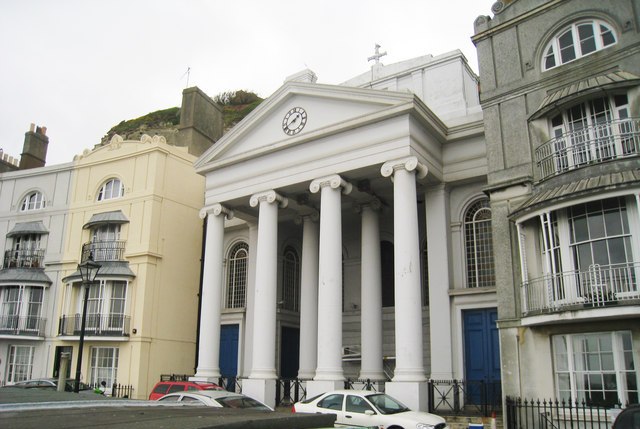
| Description | : | St Mary-in-the-Castle Church, Hastings The Church with Catacombs and a burial ground plus a further burial ground in Wallinger Walks was built in 1828 as a private chapel under a special Act of Parliament - the first incumbent being the Rev William Wallinger (1828 - 1834) The church which is of unique design, gained its inspiration from the Pantheon in Rome and has an 'inner' as well as an 'outer' wall with a wide space between to prevent dampness from the cliff, whilst the Georgian Pews are built on top of the rock face on props and inside there is... Read More |
frequently asked questions (FAQ):
-
Where is St Mary-in-the-Castle?
St Mary-in-the-Castle is located at Hastings, Hastings Borough ,East Sussex ,England.
-
St Mary-in-the-Castle cemetery's updated grave count on graveviews.com?
0 memorials
-
Where are the coordinates of the St Mary-in-the-Castle?
Latitude: 50.8555490
Longitude: 0.5846370
Nearby Cemetories:
1. All Saints Churchyard
Hastings, Hastings Borough, England
Coordinate: 50.8593840, 0.5961820
2. St. Leonard's Churchyard
St Leonards, Hastings Borough, England
Coordinate: 50.8513100, 0.5514400
3. Hastings Cemetery and Crematorium
Hastings, Hastings Borough, England
Coordinate: 50.8805070, 0.5904080
4. St. Leonard Churchyard
Hollington, Hastings Borough, England
Coordinate: 50.8743230, 0.5379840
5. Fairlight Catholic Cemetery
Fairlight, Rother District, England
Coordinate: 50.8763470, 0.6428020
6. St. Andrew Churchyard
Fairlight, Rother District, England
Coordinate: 50.8769080, 0.6424300
7. St John the Baptist Churchyard
Westfield, Rother District, England
Coordinate: 50.9080090, 0.5729280
8. St Laurence Churchyard
Guestling, Rother District, England
Coordinate: 50.8996239, 0.6366920
9. Pett Methodist Chapel
Pett, Rother District, England
Coordinate: 50.8948184, 0.6606219
10. Crowhurst Churchyard
Crowhurst, Rother District, England
Coordinate: 50.8838070, 0.4968630
11. Saints Mary and Peter Churchyard
Pett, Rother District, England
Coordinate: 50.8944100, 0.6616400
12. St. Peter's Churchyard
Bexhill-on-Sea, Rother District, England
Coordinate: 50.8460530, 0.4787950
13. St George Churchyard
Brede, Rother District, England
Coordinate: 50.9349140, 0.5963830
14. Battle Cemetery
Battle, Rother District, England
Coordinate: 50.9155800, 0.4935500
15. All Saints and St Nicholas Churchyard
Icklesham, Rother District, England
Coordinate: 50.9171000, 0.6739770
16. Bexhill Cemetery
Bexhill-on-Sea, Rother District, England
Coordinate: 50.8587980, 0.4517460
17. Battle Abbey
Battle, Rother District, England
Coordinate: 50.9144940, 0.4875140
18. St Mary the Virgin Churchyard
Battle, Rother District, England
Coordinate: 50.9150690, 0.4883620
19. St. Laurence Churchyard
Catsfield, Rother District, England
Coordinate: 50.8938230, 0.4563190
20. St. John Baptist Anglcian Churchyard
Sedlescombe, Rother District, England
Coordinate: 50.9412440, 0.5281560
21. St. Mark's Churchyard
Bexhill-on-Sea, Rother District, England
Coordinate: 50.8456760, 0.4372000
22. BroadOak Methodist Chapel
Brede, Rother District, England
Coordinate: 50.9487320, 0.6015820
23. Saint Mary Churchyard
Udimore, Rother District, England
Coordinate: 50.9399770, 0.6508420
24. St Mary Magdalene Churchyard
Whatlington, Rother District, England
Coordinate: 50.9365900, 0.5042980