
| Memorials | : | 1 |
| Location | : | Nottingham, Nottingham Unitary Authority, England |
| Coordinate | : | 52.9568310, -1.1406580 |
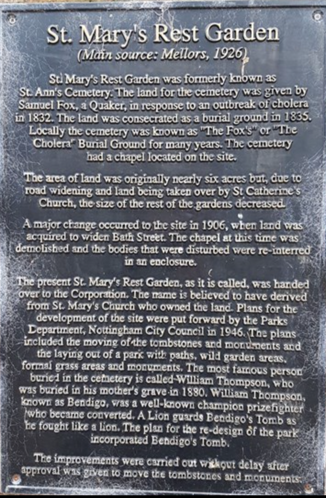
| Description | : | St. Mary's Rest Garden (Main Source: Mellors, 1926) St. Mary's Rest Garden was formerly known as St. Ann's Cemetery. The land for the cemetery was given by Samuel Fox, A Quaker, in response to an outbreak of cholera In 1832. The land was consecrated as a burial ground in 1835. Locally the cemetery was known as "The Fox's" or "The Cholera" Burial Ground for many years. The cemetery had a chapel located on the site. The area of land was originally nearly six acres but, due to road widening and land being taken over by St Catherine's Church, the size of the rest of the gardens decreased. A Major... Read More |
frequently asked questions (FAQ):
-
Where is St. Mary Rest Ground?
St. Mary Rest Ground is located at Saint Ann Nottingham, Nottingham Unitary Authority ,Nottinghamshire ,England.
-
St. Mary Rest Ground cemetery's updated grave count on graveviews.com?
1 memorials
-
Where are the coordinates of the St. Mary Rest Ground?
Latitude: 52.9568310
Longitude: -1.1406580
Nearby Cemetories:
1. St Mary's Burial Grounds
Nottingham, Nottingham Unitary Authority, England
Coordinate: 52.9527860, -1.1419160
2. National Ice Centre
Nottingham, Nottingham Unitary Authority, England
Coordinate: 52.9527790, -1.1394460
3. National Justice Museum High Pavement Nottingham
Nottingham Unitary Authority, England
Coordinate: 52.9510680, -1.1443050
4. St Peters Church Yard
Nottingham, Nottingham Unitary Authority, England
Coordinate: 52.9522800, -1.1486940
5. St Nicholas Churchyard
Nottingham, Nottingham Unitary Authority, England
Coordinate: 52.9504780, -1.1509220
6. Cathedral Church of St. Barnabas
Nottingham, Nottingham Unitary Authority, England
Coordinate: 52.9546750, -1.1570460
7. Nottingham General Cemetery
Nottingham, Nottingham Unitary Authority, England
Coordinate: 52.9575370, -1.1594236
8. Nottingham Church Cemetery
Nottingham, Nottingham Unitary Authority, England
Coordinate: 52.9649830, -1.1558070
9. General Cemetery
Nottingham, Nottingham Unitary Authority, England
Coordinate: 52.9561430, -1.1615420
10. Hardy Street Jewish Cemetery
Nottingham, Nottingham Unitary Authority, England
Coordinate: 52.9619500, -1.1665900
11. St. Paul's Churchyard
Nottingham Unitary Authority, England
Coordinate: 52.9667590, -1.1172140
12. St. John's Carrington Churchyard
Nottingham, Nottingham Unitary Authority, England
Coordinate: 52.9755350, -1.1506790
13. Holy Trinity Churchyard
Lenton, Nottingham Unitary Authority, England
Coordinate: 52.9485630, -1.1753148
14. St. Peter Churchyard Old Radford
Nottingham, Nottingham Unitary Authority, England
Coordinate: 52.9601830, -1.1789620
15. St. Wilfrid Churchyard
Wilford, Nottingham Unitary Authority, England
Coordinate: 52.9346290, -1.1587770
16. Wilford Village Cemetery
Wilford, Nottingham Unitary Authority, England
Coordinate: 52.9338540, -1.1591170
17. St. Giles's Church & Churchyard
West Bridgford, Rushcliffe Borough, England
Coordinate: 52.9316460, -1.1288450
18. Basford Cemetery
Old Basford, Nottingham Unitary Authority, England
Coordinate: 52.9799700, -1.1725900
19. St. Leodegarius Churchyard
Old Basford, Nottingham Unitary Authority, England
Coordinate: 52.9794240, -1.1778650
20. Carlton Cemetery
Nottingham, Nottingham Unitary Authority, England
Coordinate: 52.9682820, -1.0900230
21. Gedling Cemetery
Gedling, Gedling Borough, England
Coordinate: 52.9806930, -1.0870670
22. All Hallows Churchyard
Gedling, Gedling Borough, England
Coordinate: 52.9769400, -1.0805130
23. Jewish Cemetery
Nottingham, Nottingham Unitary Authority, England
Coordinate: 52.9123890, -1.1372670
24. Southern Cemetery and Crematorium
West Bridgford, Rushcliffe Borough, England
Coordinate: 52.9113900, -1.1408500