| Memorials | : | 2 |
| Location | : | Badby, Daventry District, England |
| Coordinate | : | 52.2240200, -1.1820100 |
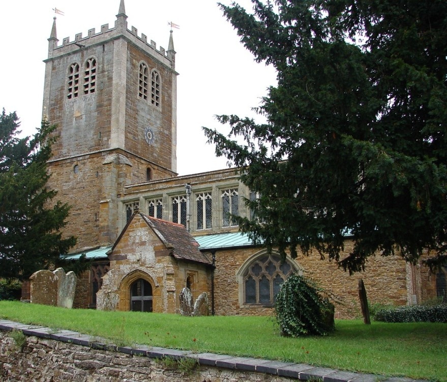
| Description | : | THE Church The main structure dates from early C14. The magnificent clerestory was added in C15. The tower was rebuilt in C18. There was a very major restoration in the late C19. A kitchen and toilet were added as a ‘north porch' in the late C20. . TOWER The tower was rebuilt in 1707-9. The height from its base to the top of the pinnacles is 72ft. Its solid floor is 6ft above the nave floor. . BELLS The rotten diagonal oak frame was replaced with a steel and iron version with a sixth bell added by John Taylor, Loughborough in 1931-2. The cracked 4th... Read More |
frequently asked questions (FAQ):
-
Where is St. Mary the Virgin?
St. Mary the Virgin is located at Badby, Daventry District ,Northamptonshire ,England.
-
St. Mary the Virgin cemetery's updated grave count on graveviews.com?
2 memorials
-
Where are the coordinates of the St. Mary the Virgin?
Latitude: 52.2240200
Longitude: -1.1820100
Nearby Cemetories:
1. St. Mary the Virgin Churchyard
Staverton, Daventry District, England
Coordinate: 52.2457070, -1.2090230
2. Holy Trinity Churchyard
Charwelton, Daventry District, England
Coordinate: 52.1952913, -1.2044410
3. Everdon Parish CHurchyard
Everdon, Daventry District, England
Coordinate: 52.2123168, -1.1310740
4. St. Peter and St. Paul Churchyard
Preston Capes, Daventry District, England
Coordinate: 52.1893410, -1.1614570
5. St. John the Baptist Churchyard
Hellidon, Daventry District, England
Coordinate: 52.2195780, -1.2464920
6. Welton Road Daventry
Daventry, Daventry District, England
Coordinate: 52.2643510, -1.1590460
7. St Mary the Virgin Churchyard
Dodford, Daventry District, England
Coordinate: 52.2396800, -1.1044500
8. St. Mary the Virgin
Farthingstone, Daventry District, England
Coordinate: 52.1899123, -1.1043480
9. All Saints Churchyard
Norton, Daventry District, England
Coordinate: 52.2681250, -1.1180030
10. St John the Baptist Church
Upper Shuckburgh, Stratford-on-Avon District, England
Coordinate: 52.2517680, -1.2732630
11. St. Leonard's Churchyard
Priors Marston, Stratford-on-Avon District, England
Coordinate: 52.2144950, -1.2852860
12. United Reformed Churchyard
Weedon Bec, Daventry District, England
Coordinate: 52.2278000, -1.0776000
13. St. Peter & St. Paul's Churchyard
Weedon Bec, Daventry District, England
Coordinate: 52.2281180, -1.0741343
14. Weedon Bec Cemetery
Weedon Bec, Daventry District, England
Coordinate: 52.2275500, -1.0715300
15. St. Martin's Churchyard
Welton, Daventry District, England
Coordinate: 52.2893100, -1.1494100
16. St Michael's Church
Stowe Nine Churches, Daventry District, England
Coordinate: 52.2120000, -1.0721000
17. All Saints Churchyard
Braunston, Daventry District, England
Coordinate: 52.2908200, -1.2140100
18. Welton Cemetery
Welton, Daventry District, England
Coordinate: 52.2932126, -1.1567336
19. Saint John the Baptist Churchyard
Lower Shuckburgh, Stratford-on-Avon District, England
Coordinate: 52.2598580, -1.2845210
20. All Saints Churchyard
Adstone, South Northamptonshire Borough, England
Coordinate: 52.1574740, -1.1306620
21. All Saints Churchyard
Flore, Daventry District, England
Coordinate: 52.2331000, -1.0615000
22. Canons Ashby
Daventry District, England
Coordinate: 52.1504600, -1.1566400
23. St. Mary’s Churchyard
Canons Ashby, Daventry District, England
Coordinate: 52.1502747, -1.1568058
24. St Mary's Churchyard
Priors Hardwick, Stratford-on-Avon District, England
Coordinate: 52.2019860, -1.3110330

