
| Memorials | : | 27 |
| Location | : | Chailey, Lewes District, England |
| Coordinate | : | 50.9720890, -0.0218170 |
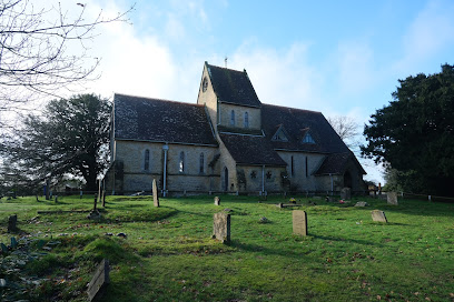
| Description | : | Situated adjacent to the busy A272, this church has been disused for some time, however the church commissioners have actively been attempting to find a commercial or community use for the building. However, despite a sign being erected offering the lease for sale, there have been no public developments to date. The churchyard is still in use for burials. |
frequently asked questions (FAQ):
-
Where is St Marys Churchyard?
St Marys Churchyard is located at Chailey, Lewes District ,East Sussex ,England.
-
St Marys Churchyard cemetery's updated grave count on graveviews.com?
27 memorials
-
Where are the coordinates of the St Marys Churchyard?
Latitude: 50.9720890
Longitude: -0.0218170
Nearby Cemetories:
1. St. Peter's Churchyard
Chailey, Lewes District, England
Coordinate: 50.9566700, -0.0191720
2. St. Mary's Churchyard
Newick, Lewes District, England
Coordinate: 50.9692030, 0.0231970
3. Begraafplaats Madonna
Langemark-Poelkapelle, Arrondissement Ieper, Belgium
Coordinate: 50.9354160, 0.0000000
4. St. Andrew and St. Mary the Virgin Churchyard
Fletching, Wealden District, England
Coordinate: 50.9929360, 0.0349030
5. Spithurst St Bartholomew Churchyard
Barcombe, Lewes District, England
Coordinate: 50.9391390, 0.0284310
6. St. Peter & St. John the Baptist Churchyard
Wivelsfield, Lewes District, England
Coordinate: 50.9708740, -0.0952190
7. Bethel Baptist Chapel
Wivelsfield, Lewes District, England
Coordinate: 50.9626990, -0.0952615
8. Western Road Cemetery
Haywards Heath, Mid Sussex District, England
Coordinate: 50.9987100, -0.0920000
9. St. Margaret of Antioch Churchyard
Isfield, Wealden District, England
Coordinate: 50.9444820, 0.0538680
10. East Chiltington Churchyard
East Chiltington, Lewes District, England
Coordinate: 50.9192280, -0.0526570
11. All Saints Churchyard
Lindfield, Mid Sussex District, England
Coordinate: 51.0163470, -0.0784980
12. St Wilfrid's Churchyard
Haywards Heath, Mid Sussex District, England
Coordinate: 50.9993130, -0.1046570
13. Danehill Cemetery
Danehill, Wealden District, England
Coordinate: 51.0295210, -0.0010970
14. Streat Churchyard
Streat, Lewes District, England
Coordinate: 50.9202600, -0.0794500
15. St Andrew Churchyard
Burgess Hill, Mid Sussex District, England
Coordinate: 50.9604300, -0.1219500
16. St Mary Churchyard
Barcombe, Lewes District, England
Coordinate: 50.9108230, 0.0165980
17. All Saints United Reformed Church
Burgess Hill, Mid Sussex District, England
Coordinate: 50.9537245, -0.1252350
18. St Giles Churchyard
Horsted Keynes, Mid Sussex District, England
Coordinate: 51.0400680, -0.0276550
19. St. John the Evangelist Churchyard
Burgess Hill, Mid Sussex District, England
Coordinate: 50.9570100, -0.1333700
20. St Bartholomew Churchyard
Maresfield, Wealden District, England
Coordinate: 50.9968350, 0.0875890
21. Holy Cross Churchyard
Uckfield, Wealden District, England
Coordinate: 50.9733690, 0.0949010
22. St Michael and All Angels Churchyard
Plumpton, Lewes District, England
Coordinate: 50.9050700, -0.0717450
23. Ditchling Cemetery
Ditchling, Lewes District, England
Coordinate: 50.9196160, -0.1050510
24. Horsted Parva Churchyard
Isfield, Wealden District, England
Coordinate: 50.9457670, 0.0918710