
| Memorials | : | 0 |
| Location | : | Parson Drove, Fenland District, England |
| Phone | : | 01945 701542 |
| Website | : | www.parsondrove.net/emmanuel.php |
| Coordinate | : | 52.6574955, 0.0285929 |
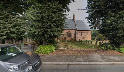
| Description | : | Its official designation is Emmanuel Church, Southea - which can cause confusion to visitors searching for the village of Southea which appears not to exist on many maps or in directories. It is now more commonly and locally referred to as Emmanuel Church, Parson Drove. A visitor from English Heritage describes the design of the church as “being unusual , being built of red brick with horizontal lines of black brick all around the outside at varying levels. It has a steep, slated roof, a small sanctus bell turret and a south porch of blackened wood. ” ... Read More |
frequently asked questions (FAQ):
-
Where is Emmanual Anglican Cemetery?
Emmanual Anglican Cemetery is located at Main Rd, Parson Drove, Wisbech, Cambs Parson Drove, Fenland District ,Cambridgeshire , PE13 4JAEngland.
-
Emmanual Anglican Cemetery cemetery's updated grave count on graveviews.com?
0 memorials
-
Where are the coordinates of the Emmanual Anglican Cemetery?
Latitude: 52.6574955
Longitude: 0.0285929
Nearby Cemetories:
1. Holy Trinity Churchyard
Gedney Hill, South Holland District, England
Coordinate: 52.6826080, -0.0211840
2. St Mary Churchyard
Wisbech St Mary, Fenland District, England
Coordinate: 52.6523950, 0.0983170
3. Guyhirn Old Churchyard
Guyhirn, Fenland District, England
Coordinate: 52.6155700, 0.0714900
4. St Paul Churchyard
Gorefield, Fenland District, England
Coordinate: 52.6873400, 0.0944700
5. Gorefield Congregational Churchyard
Gorefield, Fenland District, England
Coordinate: 52.6865500, 0.0968700
6. St. John the Baptist Churchyard
Whaplode Drove, South Holland District, England
Coordinate: 52.7034435, -0.0476688
7. St Peter & St Paul Churchyard
Wisbech, Fenland District, England
Coordinate: 52.6639880, 0.1626020
8. St Augustine Churchyard
Wisbech, Fenland District, England
Coordinate: 52.6679000, 0.1633300
9. Mount Pleasant Cemetery
Wisbech, Fenland District, England
Coordinate: 52.6719840, 0.1644770
10. St. Giles' Churchyard
Tydd St Giles, Fenland District, England
Coordinate: 52.7269470, 0.1118120
11. Elm Cemetery
Wisbech, Fenland District, England
Coordinate: 52.6360700, 0.1691800
12. All Saints
Wisbech, Fenland District, England
Coordinate: 52.6398010, 0.1707000
13. St. John's Churchyard
Holbeach, South Holland District, England
Coordinate: 52.7457510, -0.0024000
14. St. Mary and St. Botolph Churchyard
Thorney, Peterborough Unitary Authority, England
Coordinate: 52.6204260, -0.1069770
15. Thorney Abbey
Thorney, Peterborough Unitary Authority, England
Coordinate: 52.6204590, -0.1072060
16. Thorney Cemetery
Thorney, Peterborough Unitary Authority, England
Coordinate: 52.6163700, -0.1044200
17. All Saints Churchyard
Walsoken, Kings Lynn and West Norfolk Borough, England
Coordinate: 52.6721700, 0.1816130
18. St. Mary's Churchyard
March, Fenland District, England
Coordinate: 52.5648400, 0.0632100
19. St. Edmund Churchyard
Emneth, Kings Lynn and West Norfolk Borough, England
Coordinate: 52.6438200, 0.1989100
20. Station Road Cemetery
March, Fenland District, England
Coordinate: 52.5565100, 0.0920400
21. St. Mary Churchyard
Tydd St Mary, South Holland District, England
Coordinate: 52.7456600, 0.1404600
22. Holy Trinity Churchyard
Coates, Fenland District, England
Coordinate: 52.5626500, -0.0756700
23. Crowland Abbey
Crowland, South Holland District, England
Coordinate: 52.6763800, -0.1654240
24. Eastwood Cemetery
March, Fenland District, England
Coordinate: 52.5433080, 0.0954320