
| Memorials | : | 10 |
| Location | : | Upwell, Kings Lynn and West Norfolk Borough, England |
| Coordinate | : | 52.5878110, 0.2070450 |
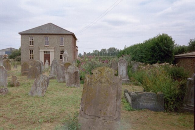
| Description | : | The Baptist Chapel was on the south side of Upwell on the road out to Three Holes and Christchurch. It dated from 1844 onwards - and had a substantial cemetery. The Upwell area was a hotbed of Non-Conformism and with this Cemetery being the only Non-Conformist Cemetery, Methodists and Baptists alike were buried there. The last recorded burial was in 1984. The cemetery was bulldozed in 2005 when the Chapel was converted into a private home. All the memorials were destroyed but their inscriptions had been recorded by The Fenland Family History Society. |
frequently asked questions (FAQ):
-
Where is Upwell Baptist Chapel?
Upwell Baptist Chapel is located at Upwell, Kings Lynn and West Norfolk Borough ,Norfolk ,England.
-
Upwell Baptist Chapel cemetery's updated grave count on graveviews.com?
10 memorials
-
Where are the coordinates of the Upwell Baptist Chapel?
Latitude: 52.5878110
Longitude: 0.2070450
Nearby Cemetories:
1. St. Peter's Churchyard
Upwell, Kings Lynn and West Norfolk Borough, England
Coordinate: 52.6018160, 0.2219280
2. Upwell Cemetery
Upwell, Kings Lynn and West Norfolk Borough, England
Coordinate: 52.6023700, 0.2229300
3. St. Clement Churchyard
Outwell, Kings Lynn and West Norfolk Borough, England
Coordinate: 52.6096650, 0.2340700
4. Outwell Cemetery
Outwell, Kings Lynn and West Norfolk Borough, England
Coordinate: 52.6092800, 0.2363600
5. Christ Church Churchyard
Christchurch, Fenland District, England
Coordinate: 52.5456560, 0.2007360
6. Elm Cemetery
Wisbech, Fenland District, England
Coordinate: 52.6360700, 0.1691800
7. St. Edmund Churchyard
Emneth, Kings Lynn and West Norfolk Borough, England
Coordinate: 52.6438200, 0.1989100
8. All Saints
Wisbech, Fenland District, England
Coordinate: 52.6398010, 0.1707000
9. Nordelph Cemetery
Nordelph, Kings Lynn and West Norfolk Borough, England
Coordinate: 52.5836400, 0.3015100
10. St. Mary the Virgin Churchyard
Welney, Kings Lynn and West Norfolk Borough, England
Coordinate: 52.5212100, 0.2479820
11. Marshland St. James Cemetery
Marshland St James, Kings Lynn and West Norfolk Borough, England
Coordinate: 52.6604540, 0.2465520
12. Station Road Cemetery
March, Fenland District, England
Coordinate: 52.5565100, 0.0920400
13. St Peter & St Paul Churchyard
Wisbech, Fenland District, England
Coordinate: 52.6639880, 0.1626020
14. Eastwood Cemetery
March, Fenland District, England
Coordinate: 52.5433080, 0.0954320
15. St Augustine Churchyard
Wisbech, Fenland District, England
Coordinate: 52.6679000, 0.1633300
16. All Saints Churchyard
Walsoken, Kings Lynn and West Norfolk Borough, England
Coordinate: 52.6721700, 0.1816130
17. Guyhirn Old Churchyard
Guyhirn, Fenland District, England
Coordinate: 52.6155700, 0.0714900
18. Mount Pleasant Cemetery
Wisbech, Fenland District, England
Coordinate: 52.6719840, 0.1644770
19. St. Wendreda's Churchyard
March, Fenland District, England
Coordinate: 52.5364880, 0.0849940
20. St. Mary's Churchyard
March, Fenland District, England
Coordinate: 52.5648400, 0.0632100
21. St Mary Churchyard
Wisbech St Mary, Fenland District, England
Coordinate: 52.6523950, 0.0983170
22. St. Peter's Churchyard
Stow Bridge, Kings Lynn and West Norfolk Borough, England
Coordinate: 52.6312500, 0.3508300
23. St Mary Churchyard
Denver, Kings Lynn and West Norfolk Borough, England
Coordinate: 52.5886240, 0.3819980
24. Churchside Cemetery
Downham Market, Kings Lynn and West Norfolk Borough, England
Coordinate: 52.6027720, 0.3807240