
| Memorials | : | 178 |
| Location | : | Headcorn, Maidstone Borough, England |
| Coordinate | : | 51.1678543, 0.6203760 |
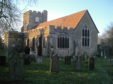
| Description | : | St Peter's and St Paul's Church is a parish church in Headcorn, Kent. began in the 13th century and continued during the 14th and 15th centuries. The church is constructed of Bethersden marble and has plain tiled roofs. It was restored in 1854-5 and 1868 by Clarke, and 1878 by G.M. Hills. The churchyard extends east from the church and contains a number of Grade II listed 18th century table tombs. |
frequently asked questions (FAQ):
-
Where is St. Peter and St. Paul Churchyard?
St. Peter and St. Paul Churchyard is located at Headcorn, Maidstone Borough ,Kent , TN27 9NREngland.
-
St. Peter and St. Paul Churchyard cemetery's updated grave count on graveviews.com?
178 memorials
-
Where are the coordinates of the St. Peter and St. Paul Churchyard?
Latitude: 51.1678543
Longitude: 0.6203760
Nearby Cemetories:
1. Headcorn Methodist Churchyard
Headcorn, Maidstone Borough, England
Coordinate: 51.1674940, 0.6205670
2. Headcorn War Memorial
Headcorn, Maidstone Borough, England
Coordinate: 51.1677480, 0.6212560
3. Headcorn Parish Burial Ground
Headcorn, Maidstone Borough, England
Coordinate: 51.1671257, 0.6204750
4. Headcorn Baptist Churchyard
Headcorn, Maidstone Borough, England
Coordinate: 51.1674156, 0.6247670
5. Ebeneezer Chapel
Biddenden, Ashford Borough, England
Coordinate: 51.1383320, 0.6416030
6. Frittenden Burial Gound
Frittenden, Tunbridge Wells Borough, England
Coordinate: 51.1428480, 0.5870820
7. St. Mary's Churchyard
Frittenden, Tunbridge Wells Borough, England
Coordinate: 51.1391190, 0.5904720
8. Marian Martyrs Memorial
Staplehurst, Maidstone Borough, England
Coordinate: 51.1649780, 0.5523900
9. All Saints Church
Staplehurst, Maidstone Borough, England
Coordinate: 51.1582160, 0.5527170
10. St. Michael the Archangel Churchyard
Smarden, Ashford Borough, England
Coordinate: 51.1490030, 0.6861940
11. St. Peter and St. Paul Churchyard
East Sutton, Maidstone Borough, England
Coordinate: 51.2159000, 0.6159000
12. Sutton Valence War Memorial
Sutton Valence, Maidstone Borough, England
Coordinate: 51.2131810, 0.5911370
13. St Mary the Virgin Churchyard
Sutton Valence, Maidstone Borough, England
Coordinate: 51.2132540, 0.5897170
14. All Saints Churchyard
Ulcombe, Maidstone Borough, England
Coordinate: 51.2171930, 0.6426440
15. All Saints Churchyard Extension
Ulcombe, Maidstone Borough, England
Coordinate: 51.2178000, 0.6420200
16. St. Michael's Churchyard
Chart Sutton, Maidstone Borough, England
Coordinate: 51.2154120, 0.5821570
17. All Saints Churchyard
Biddenden, Ashford Borough, England
Coordinate: 51.1150740, 0.6403990
18. Egerton Free Church Graveyard
Egerton, Ashford Borough, England
Coordinate: 51.1871830, 0.7050080
19. St. Nicholas' Churchyard
Boughton Malherbe, Maidstone Borough, England
Coordinate: 51.2142160, 0.6935330
20. Sissinghurst Cemetery
Sissinghurst, Tunbridge Wells Borough, England
Coordinate: 51.1095310, 0.5629240
21. St Mary's Church
Langley, Maidstone Borough, England
Coordinate: 51.2340870, 0.5847120
22. St. James Churchyard
Egerton, Ashford Borough, England
Coordinate: 51.1953860, 0.7295170
23. St. Peter's Churchyard
Boughton Monchelsea, Maidstone Borough, England
Coordinate: 51.2207560, 0.5348660
24. St. Michael and All Angels Churchyard
Marden, Maidstone Borough, England
Coordinate: 51.1743202, 0.4931720