
| Memorials | : | 4 |
| Location | : | Kern County, USA |
| Coordinate | : | 35.0422000, -118.6553900 |
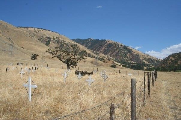
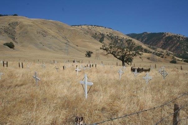
| Description | : | -- -- The Sebastian Indian Reservation, more commonly known as Tejon Indian Reservation, was located in the southern end of the San Joaquin Valley, "between Tejon Vaquero Headquarters and Canada de las Uvas. . . ." (Latta, 1977:736) Note: The State Historical Marker, located in Grapevive (Grapevine, NE corner of Grapevine Rd and 'D' St, 70 mi S of Mettler), states: "The Sebastian or Tejon Indian Reservation (headquarters 10 miles east of here)" In 1916 Mrs. Duarte who "died at the Indian Settlement six miles above the Tejon Ranch" "remains taken two miles from the village." Also this: " THE LAST OCCUPIED AREA OF... Read More |
frequently asked questions (FAQ):
-
Where is Tejon Indian Settlement Cemetery?
Tejon Indian Settlement Cemetery is located at Kern County ,California ,USA.
-
Tejon Indian Settlement Cemetery cemetery's updated grave count on graveviews.com?
4 memorials
-
Where are the coordinates of the Tejon Indian Settlement Cemetery?
Latitude: 35.0422000
Longitude: -118.6553900

Nearby Cemetories:
1. Tehachapi Cove Cemetery
Tehachapi, Kern County, USA
Coordinate: 35.1190000, -118.5724600
2. Brite Family Cemetery
Tehachapi, Kern County, USA
Coordinate: 35.1085350, -118.5473470
3. Fickert Family Cemetery
Bear Valley Springs, Kern County, USA
Coordinate: 35.1697260, -118.6443350
4. Old Tehachapi Cemetery
Tehachapi, Kern County, USA
Coordinate: 35.1400990, -118.4795570
5. Tehachapi Westside Cemetery
Tehachapi, Kern County, USA
Coordinate: 35.1387400, -118.4633600
6. Cesar E. Chavez National Monument
Keene, Kern County, USA
Coordinate: 35.2236000, -118.5592400
7. Buhn Ranch Cemetery
Tehachapi, Kern County, USA
Coordinate: 35.1352210, -118.4319290
8. Bakersfield National Cemetery
Arvin, Kern County, USA
Coordinate: 35.2559600, -118.6693480
9. Tehachapi Eastside Cemetery
Tehachapi, Kern County, USA
Coordinate: 35.1329000, -118.4153200
10. James Foley Gravesite
Tehachapi, Kern County, USA
Coordinate: 35.0509590, -118.3561170
11. Peter Lebeck Gravesite
Lebec, Kern County, USA
Coordinate: 34.8743040, -118.8926210
12. Arvin Cemetery
Arvin, Kern County, USA
Coordinate: 35.2132300, -118.8952700
13. Fort Tejon Military Cemetery
Lebec, Kern County, USA
Coordinate: 34.8720500, -118.8971500
14. Sand Canyon Cemetery
Tehachapi, Kern County, USA
Coordinate: 35.1331320, -118.3150210
15. Paris-Loraine Cemetery
Loraine, Kern County, USA
Coordinate: 35.3059000, -118.4355000
16. Islamic Cemetery and Masjid
Rosamond, Kern County, USA
Coordinate: 34.8385340, -118.3402240
17. Rankin Cemetery
Walker Basin, Kern County, USA
Coordinate: 35.3844560, -118.5388890
18. Hillcrest Memorial Park
Bakersfield, Kern County, USA
Coordinate: 35.3814316, -118.9012527
19. Mojave Cemetery
Mojave, Kern County, USA
Coordinate: 35.0550117, -118.1694565
20. Greenlawn Southwest Mortuary and Cemetery
Bakersfield, Kern County, USA
Coordinate: 35.2948990, -119.0330810
21. Williams Burial Site
Walker Basin, Kern County, USA
Coordinate: 35.4320950, -118.4815680
22. Union Cemetery
Bakersfield, Kern County, USA
Coordinate: 35.3646500, -118.9948700
23. Home of Peace Jewish Cemetery
Bakersfield, Kern County, USA
Coordinate: 35.3631500, -118.9987400
24. Chinese Cemetery
Bakersfield, Kern County, USA
Coordinate: 35.3510550, -119.0273380