
| Memorials | : | 1 |
| Location | : | Broseley, Shropshire Unitary Authority, England |
| Coordinate | : | 52.6205367, -2.4753955 |
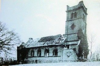
| Description | : | This is the graveyard of the demolished St Mary's Church, known as The Red Church. Only a few memorials still exist, most are beneath the demolition rubble or have been vandalised. Between 1767 and 1885, when the church was 'closed', over 1,200 persons were laid to rest here. |
frequently asked questions (FAQ):
-
Where is The Red Church?
The Red Church is located at Broseley, Shropshire Unitary Authority ,Shropshire ,England.
-
The Red Church cemetery's updated grave count on graveviews.com?
1 memorials
-
Where are the coordinates of the The Red Church?
Latitude: 52.6205367
Longitude: -2.4753955
Nearby Cemetories:
1. All Saints Churchyard
Broseley, Shropshire Unitary Authority, England
Coordinate: 52.6105890, -2.4757160
2. Broseley Baptist Church
Broseley, Shropshire Unitary Authority, England
Coordinate: 52.6135650, -2.4871190
3. St. Luke's Churchyard
Ironbridge, Telford and Wrekin Unitary Authority, England
Coordinate: 52.6285830, -2.4851180
4. Castle Green Cemetery
Ironbridge, Telford and Wrekin Unitary Authority, England
Coordinate: 52.6346434, -2.4851070
5. Holy Trinity Churchyard
Coalbrookdale, Telford and Wrekin Unitary Authority, England
Coordinate: 52.6375300, -2.4894000
6. St. Bartholomew Churchyard
Benthall, Shropshire Unitary Authority, England
Coordinate: 52.6198230, -2.5068570
7. St. Michael's Churchyard
Madeley, Telford and Wrekin Unitary Authority, England
Coordinate: 52.6337300, -2.4503010
8. Coalbrookdale Quaker Burial Ground
Coalbrookdale, Telford and Wrekin Unitary Authority, England
Coordinate: 52.6417080, -2.4952200
9. St. Giles Church Cemetery
Barrow, Shropshire Unitary Authority, England
Coordinate: 52.5969300, -2.5065700
10. Holy Trinity Churchyard
Dawley, Telford and Wrekin Unitary Authority, England
Coordinate: 52.6551528, -2.4637860
11. St. Luke's Churchyard
Doseley, Telford and Wrekin Unitary Authority, England
Coordinate: 52.6560410, -2.4775480
12. St James Churchyard
Stirchley, Telford and Wrekin Unitary Authority, England
Coordinate: 52.6575707, -2.4451542
13. Holy Trinity Churchyard
Buildwas, Shropshire Unitary Authority, England
Coordinate: 52.6393710, -2.5380180
14. St. Lawrence's Churchyard
Little Wenlock, Telford and Wrekin Unitary Authority, England
Coordinate: 52.6582070, -2.5234340
15. St. Leonard's Churchyard
Dawley, Telford and Wrekin Unitary Authority, England
Coordinate: 52.6695331, -2.4609601
16. Dawley Baptist Chapel Cemetery
Dawley, Telford and Wrekin Unitary Authority, England
Coordinate: 52.6745400, -2.4689600
17. St Johns Church
Lawley, Telford and Wrekin Unitary Authority, England
Coordinate: 52.6751550, -2.4932670
18. St. Calixtus Churchyard
Astley Abbotts, Shropshire Unitary Authority, England
Coordinate: 52.5631160, -2.4312720
19. St. Peters Churchyard
Telford and Wrekin Unitary Authority, England
Coordinate: 52.6871100, -2.4404680
20. St. Mary the Virgin Churchyard
Ketley, Telford and Wrekin Unitary Authority, England
Coordinate: 52.6914797, -2.4701998
21. Red Lake Garden of rest
Telford, Telford and Wrekin Unitary Authority, England
Coordinate: 52.6928969, -2.4715920
22. Holy Trinity Churchyard
Oakengates, Telford and Wrekin Unitary Authority, England
Coordinate: 52.6925070, -2.4562980
23. St. Mary's Churchyard
Acton Round, Shropshire Unitary Authority, England
Coordinate: 52.5573080, -2.5406470
24. St. Mary's Churchyard
Harley, Shropshire Unitary Authority, England
Coordinate: 52.6094750, -2.5976600