
| Memorials | : | 7 |
| Location | : | Trawden Forest, Pendle Borough, England |
| Coordinate | : | 53.8459885, -2.1355791 |
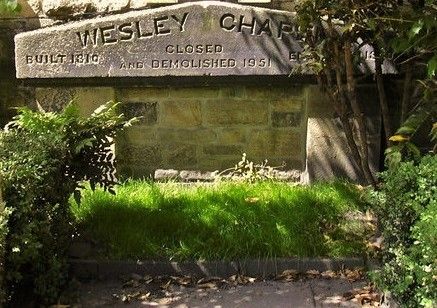
| Description | : | Trawden Wesley Chapel Site The Wesleyan Methodist Chapel was built on land called Jumb given by William Midgley of Stunstead in 1805. It was enlarged in 1850 and again in 1890. It was demolished in 1951 and the Sunday School used as a chapel until 1975 when it closed. The site of the original chapel is now occupied by Chapel House. |
frequently asked questions (FAQ):
-
Where is Trawden Wesley Chapel Graveyard?
Trawden Wesley Chapel Graveyard is located at Church Street, Trawden, Colne, Lancashire. Trawden Forest, Pendle Borough ,Lancashire , BB88 8RUEngland.
-
Trawden Wesley Chapel Graveyard cemetery's updated grave count on graveviews.com?
7 memorials
-
Where are the coordinates of the Trawden Wesley Chapel Graveyard?
Latitude: 53.8459885
Longitude: -2.1355791
Nearby Cemetories:
1. St. Mary the Virgin Churchyard
Trawden Forest, Pendle Borough, England
Coordinate: 53.8431010, -2.1366050
2. New Lane Inghamite Cemetery
Winewall, Pendle Borough, England
Coordinate: 53.8548000, -2.1367150
3. Christ Church Churchyard
Colne, Pendle Borough, England
Coordinate: 53.8602110, -2.1415670
4. Colne Cemetery
Colne, Pendle Borough, England
Coordinate: 53.8577420, -2.1585350
5. West Street Inghamite Chapel Chapelyard
Colne, Pendle Borough, England
Coordinate: 53.8555930, -2.1672140
6. St. Bartholomew Churchyard
Colne, Pendle Borough, England
Coordinate: 53.8570600, -2.1700470
7. John Ecroyd's Orchard
Lancaster, City of Lancaster, England
Coordinate: 53.8201990, -2.1697920
8. St. Michael's Churchyard
Foulridge, Pendle Borough, England
Coordinate: 53.8734569, -2.1693508
9. Friends Burial Ground
Foulridge, Pendle Borough, England
Coordinate: 53.8769360, -2.1669040
10. Nelson Cemetery
Nelson, Pendle Borough, England
Coordinate: 53.8420330, -2.1972230
11. St. John the Evangelist Churchyard
Nelson, Pendle Borough, England
Coordinate: 53.8367000, -2.1977200
12. Hill Lane Baptist Church Churchyard
Briercliffe, Burnley Borough, England
Coordinate: 53.8161467, -2.1875368
13. Barrowford Cemetery
Nelson, Pendle Borough, England
Coordinate: 53.8521100, -2.2130300
14. Haggate Baptist Church Burial Ground
Burnley Borough, England
Coordinate: 53.8145048, -2.1960725
15. St. Thomas Churchyard
Barrowford, Pendle Borough, England
Coordinate: 53.8513900, -2.2196600
16. St. Paul's Churchyard
Nelson, Pendle Borough, England
Coordinate: 53.8289250, -2.2157520
17. St. James' Churchyard
Briercliffe, Burnley Borough, England
Coordinate: 53.8107700, -2.2031800
18. St Mary's Churchyard
Kelbrook, Pendle Borough, England
Coordinate: 53.8991000, -2.1494100
19. Marsden Friends Burial Ground
Marsden, Metropolitan Borough of Kirklees, England
Coordinate: 53.8241910, -2.2197410
20. All Souls Cemetery
Barrowford, Pendle Borough, England
Coordinate: 53.8462900, -2.2355600
21. Holy Trinity Churchyard
Cowling, Craven District, England
Coordinate: 53.8837150, -2.0503150
22. Holy Trinity Churchyard
Cowling, Craven District, England
Coordinate: 53.8836930, -2.0502720
23. Cowling Holy Trinity Churchyard
Cowling, Craven District, England
Coordinate: 53.8836542, -2.0473431
24. St Andrew Methodist Cemetery
Cowling, Craven District, England
Coordinate: 53.8830940, -2.0465580