
| Memorials | : | 19 |
| Location | : | Cadiz, Harrison County, USA |
| Coordinate | : | 40.2285995, -80.9366989 |
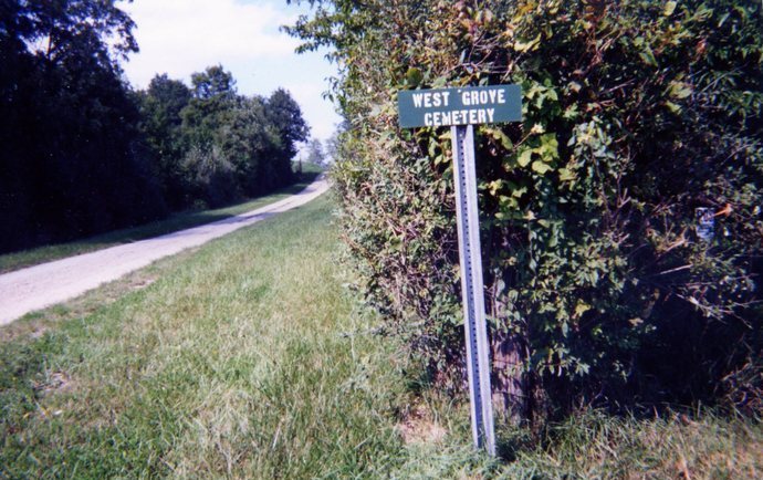
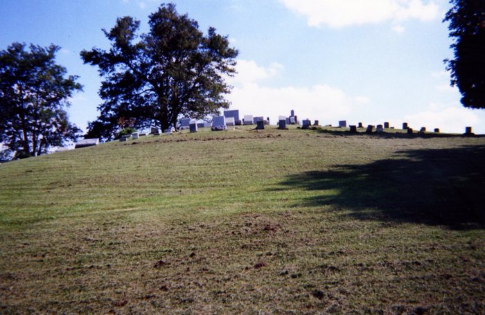
| Description | : | The cemetery is located on west side of West Grove Road (County Road 78) about 0.6 mile north of its intersection with Cadiz-Harrisville Road (US 250). The cemetery was established in 1867 and is 3.08 acres in size. The cemetery is located in Short Creek Township, Harrison County, Ohio, and is # 5044 (Friends Cemetery / West Grove Cemetery) in “Ohio Cemeteries 1803-2003”, compiled by the Ohio Genealogical Society. The cemetery is registered with the Ohio Division of Real Estate and Professional Licensing (ODRE) as West Grove Cemetery with registration license number CGR.0000981378. The U.S. Geological Survey (USGS) Geographic... Read More |
frequently asked questions (FAQ):
-
Where is West Grove Cemetery?
West Grove Cemetery is located at West Grove Road (County Road 78) Cadiz, Harrison County ,Ohio , 43907USA.
-
West Grove Cemetery cemetery's updated grave count on graveviews.com?
15 memorials
-
Where are the coordinates of the West Grove Cemetery?
Latitude: 40.2285995
Longitude: -80.9366989
Nearby Cemetories:
1. Short Creek Cemetery
Georgetown, Harrison County, USA
Coordinate: 40.2139015, -80.9278030
2. Georgetown Graveyard
Harrisville, Harrison County, USA
Coordinate: 40.2138830, -80.9275670
3. Furbay Cemetery
Georgetown, Harrison County, USA
Coordinate: 40.2155991, -80.9227982
4. Dickerson Church Cemetery
Cadiz, Harrison County, USA
Coordinate: 40.2308006, -80.9839020
5. Adena Presbyterian Church Cemetery
Smithfield, Jefferson County, USA
Coordinate: 40.2161805, -80.8742561
6. Olive Branch Cemetery
Harrisville, Harrison County, USA
Coordinate: 40.1810989, -80.8953018
7. Longview Cemetery
New Athens, Harrison County, USA
Coordinate: 40.1911011, -80.9931030
8. Friends Meeting House Cemetery
Adena, Jefferson County, USA
Coordinate: 40.1903970, -80.8805160
9. Cadiz Union Cemetery
Cadiz, Harrison County, USA
Coordinate: 40.2705994, -80.9882965
10. Rehoboth Cemetery
Smithfield Township, Jefferson County, USA
Coordinate: 40.2336006, -80.8593979
11. Stiers Cemetery
Harrisville, Harrison County, USA
Coordinate: 40.1692009, -80.9400024
12. Alley Cemetery
Harrisville, Harrison County, USA
Coordinate: 40.1828003, -80.8861008
13. Old Cadiz Cemetery
Cadiz, Harrison County, USA
Coordinate: 40.2694016, -80.9981003
14. Wilson Cemetery
Mount Pleasant Township, Jefferson County, USA
Coordinate: 40.1824989, -80.8807983
15. New Athens Methodist Episcopal Cemetery
New Athens, Harrison County, USA
Coordinate: 40.1851270, -80.9969550
16. Holmes Pioneer Cemetery
Adena, Jefferson County, USA
Coordinate: 40.2182999, -80.8527985
17. Saint Casimirs Roman Catholic Church Cemetery
Smithfield, Jefferson County, USA
Coordinate: 40.2131004, -80.8510971
18. Beech Spring Cemetery
Hopedale, Harrison County, USA
Coordinate: 40.2933006, -80.8936005
19. Unity Cemetery
Fairpoint, Belmont County, USA
Coordinate: 40.1522920, -80.9723180
20. Mattern Cemetery
Harrison County, USA
Coordinate: 40.3064003, -80.9756012
21. Crabapple Cemetery
Wheeling Township, Belmont County, USA
Coordinate: 40.1556015, -80.9953003
22. Greenwood Cemetery
Hopedale, Harrison County, USA
Coordinate: 40.3153000, -80.9313965
23. Wheeling Valley Cemetery
Fairpoint, Belmont County, USA
Coordinate: 40.1455570, -80.9022550
24. Hopedale Cemetery
Hopedale, Harrison County, USA
Coordinate: 40.3189011, -80.8989029