
| Memorials | : | 0 |
| Location | : | Westergeest, Kollumerland en Nieuwkruisland Municipality, Netherlands |
| Coordinate | : | 53.2902000, 6.0856800 |
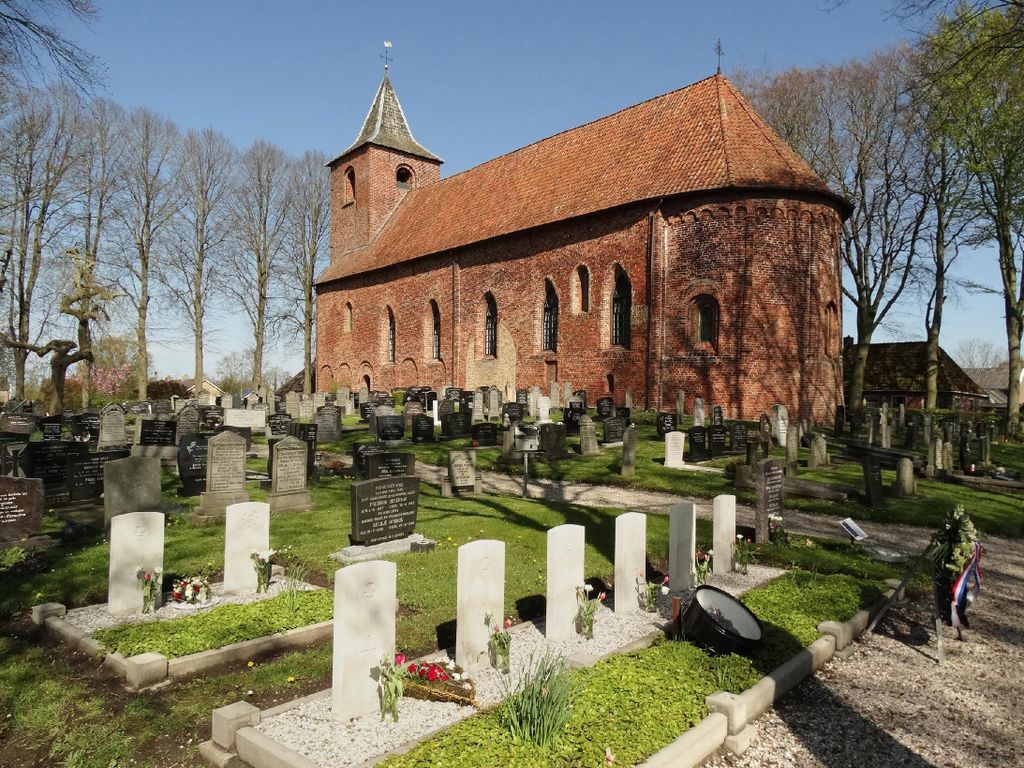
| Description | : | Westergeest, one of the villages administered by Kollumerland, is 28 kilometres north-east of Leeuwarden and 10 kilometres south-east of Dokkum. It lies 9 kilometres east of the main road between the two. The churchyard surrounds the church in the centre of the village. |
frequently asked questions (FAQ):
-
Where is Westergeest Protestant Churchyard?
Westergeest Protestant Churchyard is located at Westergeest, Kollumerland en Nieuwkruisland Municipality ,Friesland ,Netherlands.
-
Westergeest Protestant Churchyard cemetery's updated grave count on graveviews.com?
0 memorials
-
Where are the coordinates of the Westergeest Protestant Churchyard?
Latitude: 53.2902000
Longitude: 6.0856800
Nearby Cemetories:
1. Driesum Protestant Churchyard
Driezum, Dantumadeel Municipality, Netherlands
Coordinate: 53.2977400, 6.0460900
2. Rêsthôf Driezum
Driezum, Dantumadeel Municipality, Netherlands
Coordinate: 53.2948039, 6.0418101
3. Begraafplaats Nijenhof
Oudwoude, Kollumerland en Nieuwkruisland Municipality, Netherlands
Coordinate: 53.2760214, 6.1267219
4. Kerkhof Nederlands Hervormde Begraafplaats
Kollumerzwaag, Kollumerland en Nieuwkruisland Municipality, Netherlands
Coordinate: 53.2619801, 6.0736539
5. Begraafplaats Jeltingalaan
Buitenpost, Achtkarspelen Municipality, Netherlands
Coordinate: 53.2600555, 6.1359754
6. Kerkhof Dorpskerk
Engwierum, Dongeradeel Municipality, Netherlands
Coordinate: 53.3203340, 6.1362935
7. Kerkhof Nederlands Hervormde kerk De Westereen
Zwaagwesteinde, Dantumadeel Municipality, Netherlands
Coordinate: 53.2583297, 6.0348107
8. Begraafplaats Zwaagwesteinde
Zwaagwesteinde, Dantumadeel Municipality, Netherlands
Coordinate: 53.2580833, 6.0351062
9. Damwoude General Cemetery
Damwâld, Dantumadeel Municipality, Netherlands
Coordinate: 53.2857700, 5.9996900
10. Nederlands Hervormde begraafplaats Twizel
Twijzel, Achtkarspelen Municipality, Netherlands
Coordinate: 53.2388004, 6.0948838
11. Kerkhof Mariakerk
Buitenpost, Achtkarspelen Municipality, Netherlands
Coordinate: 53.2517066, 6.1449971
12. Begraafplaats Twijzelerheide
Twijzelerheide, Achtkarspelen Municipality, Netherlands
Coordinate: 53.2413444, 6.0525175
13. Begraafplaats De Westereen
Zwaagwesteinde, Dantumadeel Municipality, Netherlands
Coordinate: 53.2497819, 6.0273741
14. Rêsthôf Broeksterwâld
Broeksterwoude, Dantumadeel Municipality, Netherlands
Coordinate: 53.2758766, 5.9907295
15. Sint-Vituskerk Churchyard
Wetzens, Dongeradeel Municipality, Netherlands
Coordinate: 53.3467450, 6.0345649
16. Akkerwoude Protestant Churchyard
Akkerwoude, Dantumadeel Municipality, Netherlands
Coordinate: 53.2909300, 5.9779800
17. Begraafplaats Alde Dyk
Kootstertille, Achtkarspelen Municipality, Netherlands
Coordinate: 53.2191071, 6.1040850
18. Begraafplaats te Veenwouden Cemetery
Feanwâlden, Dantumadeel Municipality, Netherlands
Coordinate: 53.2390761, 5.9921180
19. Kleastertsjerke Cemetery
Niawier, Dongeradeel Municipality, Netherlands
Coordinate: 53.3637650, 6.0499337
20. Begraafplaats Tillebuorren
Kootstertille, Achtkarspelen Municipality, Netherlands
Coordinate: 53.2116548, 6.0919066
21. Feanwâlden Bûtefjild Cemetery
Feanwâlden, Dantumadeel Municipality, Netherlands
Coordinate: 53.2378864, 5.9815750
22. Kerkhof Alexanderkerk Rinsumageest
Rinsumageest, Dantumadeel Municipality, Netherlands
Coordinate: 53.2959488, 5.9429579
23. Anjum Protestant Churchyard
Anjum, Dongeradeel Municipality, Netherlands
Coordinate: 53.3744900, 6.1246700
24. Kloosterkapel begraafplaats
Sibrandahûs, Dantumadeel Municipality, Netherlands
Coordinate: 53.3111878, 5.9425346