
| Memorials | : | 0 |
| Location | : | Niawier, Dongeradeel Municipality, Netherlands |
| Coordinate | : | 53.3637650, 6.0499337 |
frequently asked questions (FAQ):
-
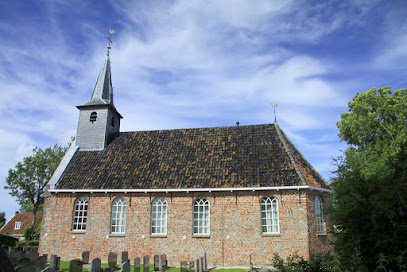
Where is Kleastertsjerke Cemetery?
Kleastertsjerke Cemetery is located at Tsjerkepaed 14 Niawier, Dongeradeel Municipality ,Friesland , 9138 SPNetherlands.
-
Kleastertsjerke Cemetery cemetery's updated grave count on graveviews.com?
0 memorials
-
Where are the coordinates of the Kleastertsjerke Cemetery?
Latitude: 53.3637650
Longitude: 6.0499337
Nearby Cemetories:
1. St. Ceciliatsjerke
Oosternijkerk, Dongeradeel Municipality, Netherlands
Coordinate: 53.3788210, 6.0531531
2. Sint-Vituskerk Churchyard
Wetzens, Dongeradeel Municipality, Netherlands
Coordinate: 53.3467450, 6.0345649
3. Nes Protestant Churchyard
Nes, Dongeradeel Municipality, Netherlands
Coordinate: 53.3962300, 6.0481500
4. Wierum Protestant Churchyard
Wierum, Dongeradeel Municipality, Netherlands
Coordinate: 53.4021700, 6.0155300
5. Moddergat Fishing Fleet Disaster Memorial
Nes, Dongeradeel Municipality, Netherlands
Coordinate: 53.4053922, 6.0762312
6. Anjum Protestant Churchyard
Anjum, Dongeradeel Municipality, Netherlands
Coordinate: 53.3744900, 6.1246700
7. Driesum Protestant Churchyard
Driezum, Dantumadeel Municipality, Netherlands
Coordinate: 53.2977400, 6.0460900
8. Kerkhof Dorpskerk
Engwierum, Dongeradeel Municipality, Netherlands
Coordinate: 53.3203340, 6.1362935
9. Rêsthôf Driezum
Driezum, Dantumadeel Municipality, Netherlands
Coordinate: 53.2948039, 6.0418101
10. Raard Protestant Churchyard
Raard, Dongeradeel Municipality, Netherlands
Coordinate: 53.3254600, 5.9444900
11. Westergeest Protestant Churchyard
Westergeest, Kollumerland en Nieuwkruisland Municipality, Netherlands
Coordinate: 53.2902000, 6.0856800
12. Kloosterkapel begraafplaats
Sibrandahûs, Dantumadeel Municipality, Netherlands
Coordinate: 53.3111878, 5.9425346
13. Damwoude General Cemetery
Damwâld, Dantumadeel Municipality, Netherlands
Coordinate: 53.2857700, 5.9996900
14. Akkerwoude Protestant Churchyard
Akkerwoude, Dantumadeel Municipality, Netherlands
Coordinate: 53.2909300, 5.9779800
15. Petruskerkhof
Lichtaard, Ferwerderadiel Municipality, Netherlands
Coordinate: 53.3263379, 5.9135862
16. Holwerd Protestant Churchyard
Holwerd, Dongeradeel Municipality, Netherlands
Coordinate: 53.3710500, 5.8972200
17. Kerkhof Alexanderkerk Rinsumageest
Rinsumageest, Dantumadeel Municipality, Netherlands
Coordinate: 53.2959488, 5.9429579
18. Rêsthôf Broeksterwâld
Broeksterwoude, Dantumadeel Municipality, Netherlands
Coordinate: 53.2758766, 5.9907295
19. Begraafplaats Nijenhof
Oudwoude, Kollumerland en Nieuwkruisland Municipality, Netherlands
Coordinate: 53.2760214, 6.1267219
20. Tsjerkhôf Jannum
Jannum, Ferwerderadiel Municipality, Netherlands
Coordinate: 53.3126308, 5.9027619
21. Kerkhof Nederlands Hervormde Begraafplaats
Kollumerzwaag, Kollumerland en Nieuwkruisland Municipality, Netherlands
Coordinate: 53.2619801, 6.0736539
22. Kerkhof Nederlands Hervormde kerk De Westereen
Zwaagwesteinde, Dantumadeel Municipality, Netherlands
Coordinate: 53.2583297, 6.0348107
23. Begraafplaats Zwaagwesteinde
Zwaagwesteinde, Dantumadeel Municipality, Netherlands
Coordinate: 53.2580833, 6.0351062
24. Atelierkerk
Ginnum, Ferwerderadiel Municipality, Netherlands
Coordinate: 53.3231763, 5.8745312