
| Memorials | : | 0 |
| Location | : | White Oak, Smith County, USA |
| Coordinate | : | 32.0692700, -89.6927900 |
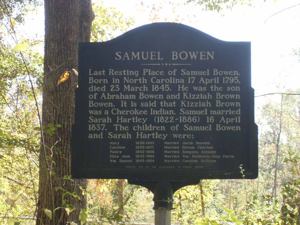
| Description | : | From Magee, MS proceed North on Mississippi Highway 541 (MS 541 aka North First Street) 14.5 miles until reaching the intersection of Mississippi Highway 18 (MS 18.) Turn Right (East) onto MS 18 and continue 2.7 miles to the intersection of Smith County Road 127 (SCR 127.) Turn Right (South) and contine 500 feet until intersecting a dirt path on the Left (East.) Carefully continue on the dirt path until reaching the small parking area at the cemetery entrance, specifically: SW1/4 NW1/4, S28, T3N-R6E, Smith, USNG 16S BA 45801 51286. Only one marker is present describing several burials. |
frequently asked questions (FAQ):
-
Where is White Oak Cemetery Old?
White Oak Cemetery Old is located at 23 SCR 127 White Oak, Smith County ,Mississippi , 39111USA.
-
White Oak Cemetery Old cemetery's updated grave count on graveviews.com?
0 memorials
-
Where are the coordinates of the White Oak Cemetery Old?
Latitude: 32.0692700
Longitude: -89.6927900
Nearby Cemetories:
1. White Oak Cemetery
White Oak, Smith County, USA
Coordinate: 32.0712800, -89.6830100
2. Miley Cemetery
Smith County, USA
Coordinate: 32.0790200, -89.7026900
3. Dukes Cemetery
Smith County, USA
Coordinate: 32.0581700, -89.6848700
4. Partridge Cemetery
Smith County, USA
Coordinate: 32.0581700, -89.6848700
5. Everett Cemetery
Smith County, USA
Coordinate: 32.0643997, -89.7182999
6. Terry Cemetery
Raleigh, Smith County, USA
Coordinate: 32.0918800, -89.6831100
7. Galilee Church Cemetery
Smith County, USA
Coordinate: 32.0478910, -89.7296920
8. Merchant Cemetery
Smith County, USA
Coordinate: 32.0335999, -89.6472015
9. Overby Cemetery
Simpson County, USA
Coordinate: 32.0233002, -89.7256012
10. Gates Cemetery
Simpson County, USA
Coordinate: 32.0454100, -89.7562100
11. Burnham Cemetery
Puckett, Rankin County, USA
Coordinate: 32.0910988, -89.7574997
12. Gates Family Cemetery
Martinville, Simpson County, USA
Coordinate: 32.0349500, -89.7498500
13. Rock Bluff Cemetery
Daniel, Smith County, USA
Coordinate: 32.1251000, -89.7165400
14. Union Baptist Church Cemetery
Mayton, Rankin County, USA
Coordinate: 32.1067009, -89.7508011
15. Steve Hughes Cemetery
Smith County, USA
Coordinate: 32.1073600, -89.6344000
16. Sardis Baptist Cemetery
Smith County, USA
Coordinate: 32.1202100, -89.6486300
17. Rock Pisgah Missionary Baptist Church Cemetery
Mendenhall, Simpson County, USA
Coordinate: 32.0201580, -89.7507140
18. Puckett Cemetery
Puckett, Rankin County, USA
Coordinate: 32.0839005, -89.7761002
19. Pleasant Hill Baptist Church Cemetery
Raleigh, Smith County, USA
Coordinate: 32.0127300, -89.6373700
20. Crossroads Holiness Church Cemetery
Raleigh, Smith County, USA
Coordinate: 32.0237000, -89.6119300
21. James Cemetery
Smith County, USA
Coordinate: 32.1516900, -89.7069400
22. Gordan Cemetery
Raleigh, Smith County, USA
Coordinate: 32.0950012, -89.5935974
23. Kennedy Springs Cemetery
Mendenhall, Simpson County, USA
Coordinate: 31.9812100, -89.7033500
24. New Home Baptist Church Cemetery
Mendenhall, Simpson County, USA
Coordinate: 31.9926610, -89.7472500