
| Memorials | : | 0 |
| Location | : | Willige Langerak, Krimpenerwaard Municipality, Netherlands |
| Coordinate | : | 51.9355100, 4.8829800 |
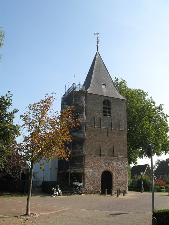
| Description | : | Willige-Langerack is a small village in, and administered by, the commune of Schoonhoven. It is about 12 kilometres east-south-east of Gouda, and 25 kilometres south-west of Utrecht. The nearest railway station is at Gouda. The church and churchyard are at the western edge of the village, about 50 yards north of the dyke road. |
frequently asked questions (FAQ):
-
Where is Willige-Langerak Churchyard?
Willige-Langerak Churchyard is located at Willige Langerak, Krimpenerwaard Municipality ,Zuid-Holland ,Netherlands.
-
Willige-Langerak Churchyard cemetery's updated grave count on graveviews.com?
0 memorials
-
Where are the coordinates of the Willige-Langerak Churchyard?
Latitude: 51.9355100
Longitude: 4.8829800
Nearby Cemetories:
1. Algemene Begraafplaats
Nieuwpoort, Molenwaard Municipality, Netherlands
Coordinate: 51.9333740, 4.8683760
2. Algemene Begraafplaats Schoonhoven
Schoonhoven, Krimpenerwaard Municipality, Netherlands
Coordinate: 51.9435400, 4.8547900
3. Roman Catholic Cemetery 1784-1873 (Defunct)
Schoonhoven, Krimpenerwaard Municipality, Netherlands
Coordinate: 51.9445176, 4.8547012
4. Joodse Begraafplaats
Schoonhoven, Krimpenerwaard Municipality, Netherlands
Coordinate: 51.9455500, 4.8546200
5. Goudriaan Algemene Begraafplaats
Goudriaan, Molenwaard Municipality, Netherlands
Coordinate: 51.9036512, 4.8883253
6. Begraafplaats Ottoland
Ottoland, Molenwaard Municipality, Netherlands
Coordinate: 51.8932730, 4.8735990
7. Polsbroek Church
Polsbroek, Lopik Municipality, Netherlands
Coordinate: 51.9755685, 4.8487430
8. Begraafplaats Noordeloos
Noordeloos, Giessenlanden Municipality, Netherlands
Coordinate: 51.9050436, 4.9412288
9. Ameide Nieuwe Begraafplaats
Ameide, Zederik Municipality, Netherlands
Coordinate: 51.9493470, 4.9665220
10. Molenaarsgraaf Protestant Churchyard
Molenaarsgraaf, Molenwaard Municipality, Netherlands
Coordinate: 51.8752300, 4.8183800
11. Krimpen aan de Lek Cemetery
Krimpenerwaard Municipality, Netherlands
Coordinate: 51.9833330, 4.7833330
12. Oudewater Protestant Cemetery
Oudewater, Oudewater Municipality, Netherlands
Coordinate: 52.0207700, 4.8762500
13. Giessen-Oudekerk Churchyard
Giessen-Oudekerk, Giessenlanden Municipality, Netherlands
Coordinate: 51.8453275, 4.8658347
14. Benschop General Cemetery
Benschop, Lopik Municipality, Netherlands
Coordinate: 52.0097300, 4.9784100
15. Boven Hardinxveld General Cemetery
Boven-Hardinxveld, Hardinxveld-Giessendam Municipality, Netherlands
Coordinate: 51.8268800, 4.8873100
16. Algemene Begraafplaats Neder Hardinxveld
Neder-Hardinxveld, Hardinxveld-Giessendam Municipality, Netherlands
Coordinate: 51.8278580, 4.8369950
17. Gorinchem Old General Cemetery
Gorinchem, Gorinchem Municipality, Netherlands
Coordinate: 51.8379600, 4.9786700
18. Heicop General Cemetery
Hei- en Boeicop, Zederik Municipality, Netherlands
Coordinate: 51.9478600, 5.0672500
19. Montfoort General Cemetery
Montfoort, Montfoort Municipality, Netherlands
Coordinate: 52.0434800, 4.9451700
20. Algemene begraafplaats Lekkerkerk
Lekkerkerk, Krimpenerwaard Municipality, Netherlands
Coordinate: 51.8986600, 4.6967709
21. Gouda Ijsselhof Cemetery
Gouda, Gouda Municipality, Netherlands
Coordinate: 52.0095400, 4.7268000
22. Werkendam Protestant Cemetery
Werkendam, Werkendam Municipality, Netherlands
Coordinate: 51.8129300, 4.8963800
23. Oude Algemene Begraafplaats
Nieuw-Lekkerland, Molenwaard Municipality, Netherlands
Coordinate: 51.8921164, 4.6930499
24. Joodse Begraafplaats
Lekkerkerk, Krimpenerwaard Municipality, Netherlands
Coordinate: 51.9026200, 4.6836500