
| Memorials | : | 0 |
| Location | : | Coshocton County, USA |
| Coordinate | : | 40.2589240, -82.1589090 |
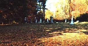
| Description | : | The cemetery is located on the northeast side of County Road 367 about 3000 feet southeast of its intersection with Township Road 411. The cemetery is located in Perry Township, Coshocton County, Ohio, and is # 2214 (Winding Fork Evangelical Cemetery) in “Ohio Cemeteries 1803-2003”, compiled by the Ohio Genealogical Society. The U.S. Geological Survey (USGS) Geographic Names Information System (GNIS) feature ID for the cemetery is 1964150 (Winding Fork Evangelical Cemetery). |
frequently asked questions (FAQ):
-
Where is Winding Fork Evangelical Lutheran Church Cemetery?
Winding Fork Evangelical Lutheran Church Cemetery is located at County Road 367 Coshocton County ,Ohio , 43843USA.
-
Winding Fork Evangelical Lutheran Church Cemetery cemetery's updated grave count on graveviews.com?
0 memorials
-
Where are the coordinates of the Winding Fork Evangelical Lutheran Church Cemetery?
Latitude: 40.2589240
Longitude: -82.1589090
Nearby Cemetories:
1. Perry Chapel Baptist Cemetery
West Carlisle, Coshocton County, USA
Coordinate: 40.2470200, -82.1899500
2. New Guilford Cemetery
Coshocton County, USA
Coordinate: 40.2896996, -82.1699982
3. Goshen Cemetery
Warsaw, Coshocton County, USA
Coordinate: 40.2728004, -82.1193008
4. VanWinkle Cemetery
Licking County, USA
Coordinate: 40.2329140, -82.1921640
5. Saint Matthews Episcopal Church Cemetery
New Guilford, Coshocton County, USA
Coordinate: 40.2964170, -82.1820690
6. Gardner Family Cemetery
West Carlisle, Coshocton County, USA
Coordinate: 40.2176510, -82.1512130
7. Scott Cemetery
Walhonding, Coshocton County, USA
Coordinate: 40.2964569, -82.1829250
8. West Carlisle Cemetery
Coshocton, Coshocton County, USA
Coordinate: 40.2308100, -82.1177700
9. Wilson Cemetery
Frampton, Licking County, USA
Coordinate: 40.2262390, -82.2059550
10. Rine Family Cemetery
Jackson Township, Knox County, USA
Coordinate: 40.2728050, -82.2224780
11. Mohawk Baptist Church Cemetery
Nellie, Coshocton County, USA
Coordinate: 40.2941380, -82.1107120
12. Wilson Chapel Cemetery
Nellie, Coshocton County, USA
Coordinate: 40.3017690, -82.1207660
13. Mount Airy Cemetery
Coshocton County, USA
Coordinate: 40.3107310, -82.1854160
14. Mikesell Cemetery
West Bedford, Coshocton County, USA
Coordinate: 40.2882500, -82.0963240
15. Mount Pleasant Cemetery
Licking County, USA
Coordinate: 40.2044200, -82.1871500
16. Proffit Family Farm Cemetery
Frazeysburg, Muskingum County, USA
Coordinate: 40.2131530, -82.2101100
17. Stricker Cemetery
Bladensburg, Knox County, USA
Coordinate: 40.2978800, -82.2227900
18. West Bedford Cemetery #1
Bedford Township, Coshocton County, USA
Coordinate: 40.2636000, -82.0739000
19. Robinson Cemetery
West Carlisle, Coshocton County, USA
Coordinate: 40.1941480, -82.1676420
20. West Bedford Cemetery #2
Bedford Township, Coshocton County, USA
Coordinate: 40.2543110, -82.0736220
21. Mount Zion Cemetery
Bladensburg, Knox County, USA
Coordinate: 40.2543800, -82.2475300
22. Broomstick Cemetery
Coshocton County, USA
Coordinate: 40.2002983, -82.1100006
23. Christian Church Cemetery
Warsaw, Coshocton County, USA
Coordinate: 40.3250000, -82.1230000
24. Varner Cemetery
Licking County, USA
Coordinate: 40.2011720, -82.2182280