
| Memorials | : | 0 |
| Location | : | Wolphaartsdijk, Goes Municipality, Netherlands |
| Coordinate | : | 51.5271200, 3.8191400 |
frequently asked questions (FAQ):
-
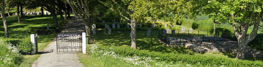
Where is Wolphaartsdijk Algemene Begraafplaats?
Wolphaartsdijk Algemene Begraafplaats is located at Wolphaartsdijk, Goes Municipality ,Zeeland ,Netherlands.
-
Wolphaartsdijk Algemene Begraafplaats cemetery's updated grave count on graveviews.com?
0 memorials
-
Where are the coordinates of the Wolphaartsdijk Algemene Begraafplaats?
Latitude: 51.5271200
Longitude: 3.8191400
Nearby Cemetories:
1. 's-Heer-Hendrikskinderen Algemene Begraafplaats
's-Heer Hendrikskinderen, Goes Municipality, Netherlands
Coordinate: 51.5012100, 3.8463800
2. Goes Algemene Begraafplaats
Goes, Goes Municipality, Netherlands
Coordinate: 51.5120600, 3.8866100
3. Wilhelminadorp General Cemetery
Wilhelminadorp, Goes Municipality, Netherlands
Coordinate: 51.5323600, 3.8916900
4. Lewedorp Kerkhof
Lewedorp, Borsele Municipality, Netherlands
Coordinate: 51.4940600, 3.7502800
5. Heinkenszand Kerklaan Cemetery
Heinkenszand, Borsele Municipality, Netherlands
Coordinate: 51.4717900, 3.8139200
6. Kats General Cemetery
Kats, Noord-Beveland Municipality, Netherlands
Coordinate: 51.5704500, 3.8825800
7. Nieuwdorp Algemene Begraafplaats
Nieuwdorp, Borsele Municipality, Netherlands
Coordinate: 51.4775300, 3.7466800
8. Crematorium en uitvaartcentrum Het Zeeuwse Land
Goes Municipality, Netherlands
Coordinate: 51.4810570, 3.8994665
9. Nieuwdorp Dutch Reformed Cemetery
Nieuwdorp, Borsele Municipality, Netherlands
Coordinate: 51.4768900, 3.7438300
10. Algemene Begraafplaats
Nisse, Borsele Municipality, Netherlands
Coordinate: 51.4584900, 3.8467600
11. Kloetinge General Cemetery
Kloetinge, Goes Municipality, Netherlands
Coordinate: 51.4971500, 3.9232100
12. 's-Heerenhoek Old Cemetery
's-Heerenhoek, Borsele Municipality, Netherlands
Coordinate: 51.4634500, 3.7642900
13. Colijnsplaat General Cemetery
Colijnsplaat, Noord-Beveland Municipality, Netherlands
Coordinate: 51.5993700, 3.8421900
14. Wissenkerke General Cemetery
Wissenkerke, Noord-Beveland Municipality, Netherlands
Coordinate: 51.5855300, 3.7439600
15. Hervormde Gemeente te Kattendijke
Kattendijke, Goes Municipality, Netherlands
Coordinate: 51.5236607, 3.9446858
16. R.K. Begraafplaats
's-Heerenhoek, Borsele Municipality, Netherlands
Coordinate: 51.4542131, 3.7715854
17. Kattendijke General Cemetery
Kattendijke, Goes Municipality, Netherlands
Coordinate: 51.5230400, 3.9476100
18. Kamperland General Cemetery
Kamperland, Noord-Beveland Municipality, Netherlands
Coordinate: 51.5720500, 3.7028400
19. 's-Gravenpolder Algemene Begraafplaats
's-Gravenpolder, Borsele Municipality, Netherlands
Coordinate: 51.4556100, 3.9003500
20. Lenshoekdijk Old
's-Gravenpolder, Borsele Municipality, Netherlands
Coordinate: 51.4554900, 3.9012800
21. Kapelle French Military Cemetery
Kapelle, Kapelle Municipality, Netherlands
Coordinate: 51.4877370, 3.9482423
22. Biezelinge Algemene Begraafplaats
Biezelinge, Kapelle Municipality, Netherlands
Coordinate: 51.4777300, 3.9575600
23. Ovezande Bloemenstraat Cemetery
Ovezande, Borsele Municipality, Netherlands
Coordinate: 51.4274400, 3.8208500
24. Begraafplaats Kerkhofring
Zanddijk, Veere Municipality, Netherlands
Coordinate: 51.5400512, 3.6583653