
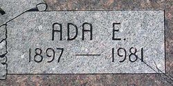
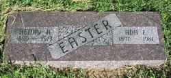
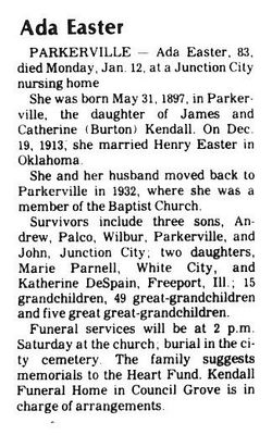
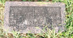
Ada Ellen Kendall Easter
| Birth | : | 31 May 1897 Parkerville, Morris County, Kansas, USA |
| Death | : | 12 Jan 1981 Junction City, Geary County, Kansas, USA |
| Burial | : | Bolckow Cemetery, Bolckow, Andrew County, USA |
| Coordinate | : | 40.1131210, -94.8142929 |
frequently asked questions (FAQ):
-
Where is Ada Ellen Kendall Easter's memorial?
Ada Ellen Kendall Easter's memorial is located at: Bolckow Cemetery, Bolckow, Andrew County, USA.
-
When did Ada Ellen Kendall Easter death?
Ada Ellen Kendall Easter death on 12 Jan 1981 in Junction City, Geary County, Kansas, USA
-
Where are the coordinates of the Ada Ellen Kendall Easter's memorial?
Latitude: 40.1131210
Longitude: -94.8142929
Family Members:
Parent

Spouse
Siblings


Children
Flowers:


Nearby Cemetories:
1. Bolckow Cemetery
Bolckow, Andrew County, USA
Coordinate: 40.1131210, -94.8142929
2. Upper Neely Grove Cemetery
Bolckow, Andrew County, USA
Coordinate: 40.1083488, -94.7961807
3. Platte Valley Cemetery
Barnard, Nodaway County, USA
Coordinate: 40.1413994, -94.7692032
4. Jackson Cemetery
Barnard, Nodaway County, USA
Coordinate: 40.1561012, -94.7842026
5. Lower Neely Grove Cemetery
Andrew County, USA
Coordinate: 40.0627594, -94.8138733
6. Walnut Grove Methodist Cemetery
Andrew County, USA
Coordinate: 40.0967598, -94.7518311
7. Litts Cemetery
Whitecloud, Nodaway County, USA
Coordinate: 40.1377983, -94.8756027
8. McBrien Cemetery
Rosendale, Andrew County, USA
Coordinate: 40.0698900, -94.8589600
9. Baker Cemetery
Barnard, Nodaway County, USA
Coordinate: 40.1660800, -94.8636600
10. Barnard American Legion Cemetery
Barnard, Nodaway County, USA
Coordinate: 40.1839600, -94.8173828
11. Barnard Masonic-IOOF Cemetery
Barnard, Nodaway County, USA
Coordinate: 40.1845818, -94.8176727
12. Alumbaugh Cemetery
Barnard, Nodaway County, USA
Coordinate: 40.1843987, -94.8383026
13. Groves Cemetery
Guilford, Nodaway County, USA
Coordinate: 40.1567001, -94.7221985
14. Weathermon Cemetery
Guilford, Nodaway County, USA
Coordinate: 40.1683998, -94.7240829
15. Graves Cemetery
Guilford, Nodaway County, USA
Coordinate: 40.1730995, -94.7276764
16. Whitesville Cemetery
Whitesville, Andrew County, USA
Coordinate: 40.0626183, -94.7162094
17. Clemmens Cemetery
Whitesville, Andrew County, USA
Coordinate: 40.0401430, -94.7413400
18. Gravel Wall Cemetery
Andrew County, USA
Coordinate: 40.0672210, -94.9260280
19. Fairview Christian Cemetery
Rosendale, Andrew County, USA
Coordinate: 40.0102090, -94.8198890
20. Salem Cemetery
Pumpkin Center, Nodaway County, USA
Coordinate: 40.2076721, -94.8683167
21. McGlothlin Cemetery
Andrew County, USA
Coordinate: 40.0097700, -94.7740400
22. Centenary Cemetery
Graham, Nodaway County, USA
Coordinate: 40.1293907, -94.9546204
23. Bethany Christian Church Cemetery
Graham, Nodaway County, USA
Coordinate: 40.1585388, -94.9461365
24. Sharp Cemetery
Barnard, Nodaway County, USA
Coordinate: 40.2176190, -94.7630450