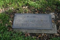
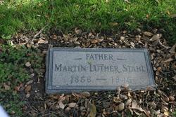
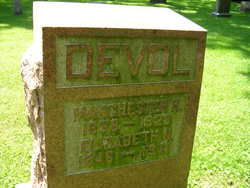
Adalaide Vesta Devol Stahl
| Birth | : | 28 Nov 1853 Carbon Hill, Hocking County, Ohio, USA |
| Death | : | 31 Jul 1915 Claremont, Los Angeles County, California, USA |
| Burial | : | Olive Branch Cemetery, White Cloud, Doniphan County, USA |
| Coordinate | : | 39.9729400, -95.3129400 |
| Description | : | Adalaide's grave marker states she was born in 1863. This can not be correct. She is found living with her parents in the 1860 census. They also had a daughter Bertha Stahl Thurmond Birth: Mar. 8, 1888 Ohio, USA Death: Oct. 23, 1976 Santa Barbara County California, USA Family links: Spouse: Hugh Gwyn Thurmond (1888 - 1939) Burial: Carpinteria Cemetery Carpinteria Santa Barbara County California, USA Plot: 217, 3 Edit Virtual Cemetery info [?] Created by: Damien Record added: Jan 28, 2009 Find A Grave Memorial# 33339357 |
frequently asked questions (FAQ):
-
Where is Adalaide Vesta Devol Stahl's memorial?
Adalaide Vesta Devol Stahl's memorial is located at: Olive Branch Cemetery, White Cloud, Doniphan County, USA.
-
When did Adalaide Vesta Devol Stahl death?
Adalaide Vesta Devol Stahl death on 31 Jul 1915 in Claremont, Los Angeles County, California, USA
-
Where are the coordinates of the Adalaide Vesta Devol Stahl's memorial?
Latitude: 39.9729400
Longitude: -95.3129400
Family Members:
Parent
Spouse
Siblings
Children
Flowers:
Nearby Cemetories:
1. Olive Branch Cemetery
White Cloud, Doniphan County, USA
Coordinate: 39.9729400, -95.3129400
2. Kelley Cemetery
White Cloud, Doniphan County, USA
Coordinate: 39.9797100, -95.3042800
3. Tesson Cemetery
Brown County, USA
Coordinate: 39.9763985, -95.3407974
4. Partlow Cemetery
Hiawatha, Brown County, USA
Coordinate: 39.9994011, -95.3602982
5. Collins Family Cemetery
White Cloud, Doniphan County, USA
Coordinate: 39.9221992, -95.2969284
6. Roy and Franklin Cemetery
Richardson County, USA
Coordinate: 40.0036011, -95.3878021
7. Franklin Cemetery
Rulo, Richardson County, USA
Coordinate: 40.0035000, -95.3884700
8. Campbell Cemetery
Reserve, Brown County, USA
Coordinate: 39.9905980, -95.3961750
9. Iowa Point Cemetery
Iowa Point, Doniphan County, USA
Coordinate: 39.9157982, -95.2275009
10. Kenyon Cemetery
Robinson, Brown County, USA
Coordinate: 39.9122000, -95.3964600
11. Walnut Grove Cemetery
Highland, Doniphan County, USA
Coordinate: 39.9000702, -95.2438736
12. Boyd Cemetery
Holt County, USA
Coordinate: 40.0466995, -95.2453003
13. Wilson Cemetery
Forest City, Holt County, USA
Coordinate: 40.0060997, -95.2027969
14. Tarkio Chapel Cemetery
Fortescue, Holt County, USA
Coordinate: 40.0659400, -95.3152200
15. Pleasant Hill Cemetery
Irving Township, Brown County, USA
Coordinate: 39.9435997, -95.4328232
16. Roderick Cemetery
Forest City, Holt County, USA
Coordinate: 40.0271988, -95.2071991
17. Union Cemetery
Forest City, Holt County, USA
Coordinate: 39.9872017, -95.1761017
18. Catron Cemetery
Fortescue, Holt County, USA
Coordinate: 40.0736300, -95.3629800
19. Laus Creek Cemetery
Reserve, Brown County, USA
Coordinate: 39.9754105, -95.4699936
20. Immaculate Conception Cemetery
Rulo, Richardson County, USA
Coordinate: 40.0480200, -95.4431800
21. Highland Cemetery
Highland, Doniphan County, USA
Coordinate: 39.8555984, -95.2514038
22. Sauer Cemetery
Bigelow, Holt County, USA
Coordinate: 40.1002100, -95.3339900
23. Benton Church Cemetery
Forest City, Holt County, USA
Coordinate: 40.0621430, -95.1918980
24. Rulo City Cemetery
Rulo, Richardson County, USA
Coordinate: 40.0561218, -95.4420471


