
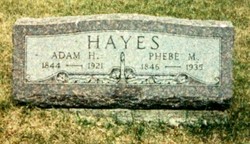
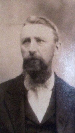
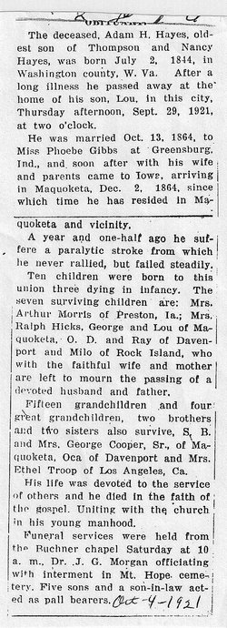
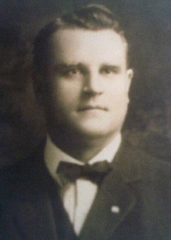
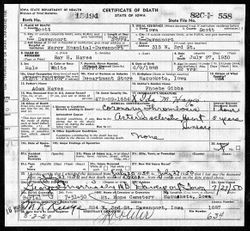
Adam Henry Hayes
| Birth | : | 2 Jul 1844 Washington County, Virginia, USA |
| Death | : | 29 Sep 1921 Maquoketa, Jackson County, Iowa, USA |
| Burial | : | Stand United Reformed Church Burial Ground, Radcliffe, Metropolitan Borough of Bury, England |
| Coordinate | : | 53.5512300, -2.3140600 |
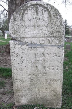
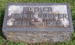
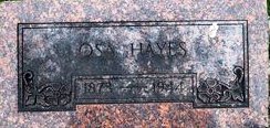
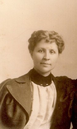
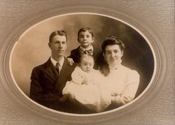
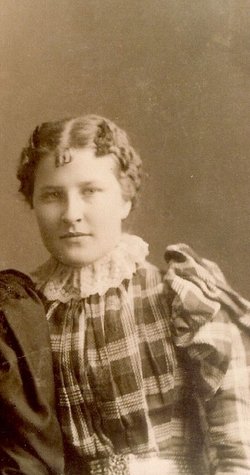
| Description | : | HUSBAND OF: Phebe Marie Hayes nee Gibbs b. 1846 IN d. 1935 IA FATHER OF: Mary A. "Allie" Hayes (Arthur R. Morris) George E.Hayes (Mary- Divorced) Oscar Day Hayes (Francis Leona Hayes nee Thompson) Milo Hayes (Blanche) Lewis Edward Hayes (Julia Manwiller) Hattie M. Hayes (Ralph Hicks) Ralph aka Ray Hayes (Ida) SON OF: Thompson Hays & Nancy Hays NEE Merrick BROTHER OF: Jeremiah Hayes b. 1846 OH d. bef 1860 John Russell Hayes b. 1848 IN d. bef 1860 Esther Hayes b. aft 1848 IN d. bef 1860 Rebecca J. "Jennie" Hayes (Mrs. George Cooper,Sr. Ethlinda "Ethel" Hayes (Mrs. Josiah Throop) Sylvester Benjamin Hayes b. 1855 IN d.... Read More |
frequently asked questions (FAQ):
-
Where is Adam Henry Hayes's memorial?
Adam Henry Hayes's memorial is located at: Stand United Reformed Church Burial Ground, Radcliffe, Metropolitan Borough of Bury, England.
-
When did Adam Henry Hayes death?
Adam Henry Hayes death on 29 Sep 1921 in Maquoketa, Jackson County, Iowa, USA
-
Where are the coordinates of the Adam Henry Hayes's memorial?
Latitude: 53.5512300
Longitude: -2.3140600
Family Members:
Parent
Spouse

Siblings
Children
Flowers:


Nearby Cemetories:
1. Stand United Reformed Church Burial Ground
Radcliffe, Metropolitan Borough of Bury, England
Coordinate: 53.5512300, -2.3140600
2. New Jerusalem Church Burial
Radcliffe, Metropolitan Borough of Bury, England
Coordinate: 53.5542680, -2.3174070
3. St. John Parish Churchyard
Radcliffe, Metropolitan Borough of Bury, England
Coordinate: 53.5571400, -2.3206700
4. All Saints Churchyard Stand
Whitefield, Metropolitan Borough of Bury, England
Coordinate: 53.5501180, -2.2985570
5. St. Thomas & St. John with St. Philip Churchyard
Radcliffe, Metropolitan Borough of Bury, England
Coordinate: 53.5625140, -2.3266770
6. St. Mary's Churchyard
Radcliffe, Metropolitan Borough of Bury, England
Coordinate: 53.5644410, -2.3081470
7. Manchester Reform Jewish Old Cemetery
Whitefield, Metropolitan Borough of Bury, England
Coordinate: 53.5442728, -2.2918894
8. Radcliffe Cemetery
Radcliffe, Metropolitan Borough of Bury, England
Coordinate: 53.5706240, -2.3294860
9. East Lancashire Crematorium
Radcliffe, Metropolitan Borough of Bury, England
Coordinate: 53.5726893, -2.3273050
10. Great Synagogue Cemetery
Prestwich, Metropolitan Borough of Bury, England
Coordinate: 53.5315510, -2.2845730
11. St. Andrew's Churchyard
Radcliffe, Metropolitan Borough of Bury, England
Coordinate: 53.5740731, -2.3377989
12. St Saviour churchyard
Ringley, Metropolitan Borough of Bolton, England
Coordinate: 53.5439030, -2.3576830
13. St. Mary the Virgin Churchyard
Prestwich, Metropolitan Borough of Bury, England
Coordinate: 53.5294033, -2.2864891
14. St Anne Churchyard
Clifton, Metropolitan Borough of Salford, England
Coordinate: 53.5277070, -2.3391650
15. Unsworth Weslyan Methodist Churchyard
Bury, Metropolitan Borough of Bury, England
Coordinate: 53.5667900, -2.2745100
16. St Georges Churchyard
Unsworth, Metropolitan Borough of Bury, England
Coordinate: 53.5668741, -2.2745340
17. St Paul Churchyard
Bury, Metropolitan Borough of Bury, England
Coordinate: 53.5789815, -2.2925926
18. Bury Cemetery
Bury, Metropolitan Borough of Bury, England
Coordinate: 53.5794850, -2.2904870
19. Christ Church Churchyard
Little Lever, Metropolitan Borough of Bolton, England
Coordinate: 53.5598101, -2.3692188
20. Rainsough Jewish Cemetery
Prestwich, Metropolitan Borough of Bury, England
Coordinate: 53.5185530, -2.2906950
21. King's Church Chapelyard
Little Lever, Metropolitan Borough of Bolton, England
Coordinate: 53.5625122, -2.3716833
22. St Stephen churchyard
Kearsley, Metropolitan Borough of Bolton, England
Coordinate: 53.5381650, -2.3717160
23. St. Matthew Churchyard
Little Lever, Metropolitan Borough of Bolton, England
Coordinate: 53.5626144, -2.3732190
24. Wellington Barracks Memorial Garden
Bury, Metropolitan Borough of Bury, England
Coordinate: 53.5882208, -2.3210890