
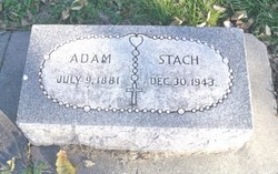
Adam Stach
| Birth | : | 9 Jul 1881 Platte County, Nebraska, USA |
| Death | : | 30 Dec 1943 Platte County, Nebraska, USA |
| Burial | : | Inskip Baptist Churchyard, Inskip with Sowerby, Wyre Borough, England |
| Coordinate | : | 53.8353150, -2.8299610 |
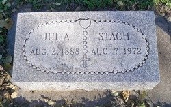
| Description | : | Son of John & Maryanna (Warzala) Stach. Married to Julia Kiolbasa on 2-10-1904 at St. Michael's Catholic Church at Tarnov, NE. Spelling of last name was changed by one son to STOCK. Mike Stock, another son, born 2-3-1915, died in July 1979 at Dearborn Heights, Wayne, MI. |
frequently asked questions (FAQ):
-
Where is Adam Stach's memorial?
Adam Stach's memorial is located at: Inskip Baptist Churchyard, Inskip with Sowerby, Wyre Borough, England.
-
When did Adam Stach death?
Adam Stach death on 30 Dec 1943 in Platte County, Nebraska, USA
-
Where are the coordinates of the Adam Stach's memorial?
Latitude: 53.8353150
Longitude: -2.8299610
Family Members:
Spouse
Children

Flowers:


Nearby Cemetories:
1. Inskip Baptist Churchyard
Inskip with Sowerby, Wyre Borough, England
Coordinate: 53.8353150, -2.8299610
2. St. Peters Churchyard
Inskip with Sowerby, Wyre Borough, England
Coordinate: 53.8347100, -2.8175200
3. St. Michael’s Churchyard
St Michael's on Wyre, Wyre Borough, England
Coordinate: 53.8628050, -2.8195430
4. Elswick Congregational Chapelyard
Elswick, Fylde Borough, England
Coordinate: 53.8378950, -2.8775320
5. St Mary Roman Catholic Churchyard
Great Eccleston, Wyre Borough, England
Coordinate: 53.8535420, -2.8710090
6. Christ Churchyard
Treales, Fylde Borough, England
Coordinate: 53.8045970, -2.8440710
7. St Anne Churchyard
Great Eccleston, Wyre Borough, England
Coordinate: 53.8481413, -2.8835925
8. St. Helen's Churchyard
Kirkland (Churchtown), Wyre Borough, England
Coordinate: 53.8790700, -2.7901000
9. Saint Anne's Church
Woodplumpton, City of Preston, England
Coordinate: 53.8038130, -2.7621940
10. Saint Joseph's Roman Catholic Church
Wesham, Fylde Borough, England
Coordinate: 53.7928600, -2.8871800
11. St. Hilda's Churchyard
Bilsborrow, Wyre Borough, England
Coordinate: 53.8522170, -2.7420090
12. St Mary's Newhouse
Barton, City of Preston, England
Coordinate: 53.8205240, -2.7406500
13. St. John’s Churchyard
Out Rawcliffe, Wyre Borough, England
Coordinate: 53.8741650, -2.8959310
14. Christ Church Churchyard
Wesham, Fylde Borough, England
Coordinate: 53.7905000, -2.8845600
15. St. Lawrence Churchyard
Barton, City of Preston, England
Coordinate: 53.8289213, -2.7366654
16. St Michael Churchyard
Kirkham, Fylde Borough, England
Coordinate: 53.7843570, -2.8709520
17. Zion Chapel Cemetery
Kirkham, Fylde Borough, England
Coordinate: 53.7814380, -2.8721260
18. St. John the Evangelist Churchyard
Clifton, Fylde Borough, England
Coordinate: 53.7758600, -2.8158500
19. Kirkland Strict and Particular Baptist Chapel
Nateby, Wyre Borough, England
Coordinate: 53.8961210, -2.8170130
20. St Anne Churchyard
Singleton, Fylde Borough, England
Coordinate: 53.8379280, -2.9359890
21. St. Anne's Churchyard
Blackburn, Blackburn with Darwen Unitary Authority, England
Coordinate: 53.8381160, -2.9362870
22. St Andrew George Haydock Roman Catholic Churchyard
Cottam, City of Preston, England
Coordinate: 53.7879280, -2.7591570
23. Saint John the Evangelist Churchyard
Kirkham, Fylde Borough, England
Coordinate: 53.7808000, -2.8873870
24. St. Mary's Churchyard
Lea, City of Preston, England
Coordinate: 53.7733810, -2.7942770