

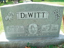
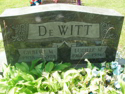
Agnes Eileen “Sis” Rodeheaver DeWitt
| Birth | : | 18 Nov 1927 Hoyes, Garrett County, Maryland, USA |
| Death | : | 25 Dec 2005 McHenry, Garrett County, Maryland, USA |
| Burial | : | Oak Grove Church of the Brethren Cemetery, McHenry, Garrett County, USA |
| Coordinate | : | 39.5694400, -79.3834300 |
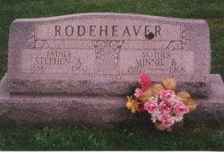
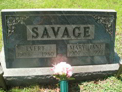
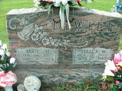
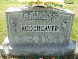
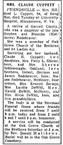
| Description | : | Agnes Eileen "Sis" DeWitt Date of Death - December 25, 2005 Agnes Eileen "Sis" DeWitt, 78, of 37 Cherry Lane Road, McHenry, MD, died Sunday, December 25, 2005 at her residence. Born November 18, 1927, Hoyes, MD she was the daughter of the late Stephen Andrew and Minnie Blanche (Matthews) Rodeheaver. She was also preceded in death by her husband Harold G. DeWitt, September 28, 2000; five brothers, Hobert, Mason, Herman, James and Robert Rodeheaver; four sisters, Mary Savage, Stella DeWitt, Lucille DeWitt, and Mildred Cuppett. She is the last surviving member of her immediate family. Mrs.... Read More |
frequently asked questions (FAQ):
-
Where is Agnes Eileen “Sis” Rodeheaver DeWitt's memorial?
Agnes Eileen “Sis” Rodeheaver DeWitt's memorial is located at: Oak Grove Church of the Brethren Cemetery, McHenry, Garrett County, USA.
-
When did Agnes Eileen “Sis” Rodeheaver DeWitt death?
Agnes Eileen “Sis” Rodeheaver DeWitt death on 25 Dec 2005 in McHenry, Garrett County, Maryland, USA
-
Where are the coordinates of the Agnes Eileen “Sis” Rodeheaver DeWitt's memorial?
Latitude: 39.5694400
Longitude: -79.3834300
Family Members:
Parent

Spouse

Siblings
Flowers:


Nearby Cemetories:
1. Oak Grove Church of the Brethren Cemetery
McHenry, Garrett County, USA
Coordinate: 39.5694400, -79.3834300
2. Hoye Family Cemetery - Crab Tree Bottom
McHenry, Garrett County, USA
Coordinate: 39.5642220, -79.3855000
3. Saint Dominic Catholic Cemetery
Hoyes, Garrett County, USA
Coordinate: 39.5868300, -79.3698600
4. Hoyes Cemetery
Garrett County, USA
Coordinate: 39.5905991, -79.3683014
5. Upper Sang Run Cemetery
McHenry, Garrett County, USA
Coordinate: 39.5717810, -79.4242430
6. Flatwood Cemetery
Accident, Garrett County, USA
Coordinate: 39.5923500, -79.3515400
7. Skiles Cemetery
Accident, Garrett County, USA
Coordinate: 39.5971570, -79.3439160
8. Bumblebee Ridge Cemetery
McHenry, Garrett County, USA
Coordinate: 39.5774400, -79.3296800
9. Hoyes Run Cemetery
Garrett County, USA
Coordinate: 39.5313100, -79.4110900
10. Bray Cemetery
Oakland, Garrett County, USA
Coordinate: 39.5006900, -79.3858100
11. Glotfelty Farm Cemetery
McHenry, Garrett County, USA
Coordinate: 39.5708800, -79.2905500
12. Bear Creek Church of the Brethren Cemetery
Accident, Garrett County, USA
Coordinate: 39.6213000, -79.3099800
13. Saint Paul's Old Cemetery
Accident, Garrett County, USA
Coordinate: 39.6287100, -79.3182100
14. Friend Cemetery
Oakland, Garrett County, USA
Coordinate: 39.4913500, -79.3778000
15. Ruckle Family Cemetery
Bittinger, Garrett County, USA
Coordinate: 39.5802600, -79.2821900
16. Cherry Glade Cemetery
Accident, Garrett County, USA
Coordinate: 39.5827200, -79.2799500
17. Glade Mennonite Cemetery
Bittinger, Garrett County, USA
Coordinate: 39.5826300, -79.2796700
18. Zion Lutheran Cemetery
Accident, Garrett County, USA
Coordinate: 39.6300510, -79.3129020
19. Taylor-Sines Cemetery
Oakland, Garrett County, USA
Coordinate: 39.4894470, -79.4165480
20. Lake Ford Cemetery
Garrett County, USA
Coordinate: 39.5278015, -79.4792023
21. Cranesville Cemetery
Cranesville, Preston County, USA
Coordinate: 39.5543920, -79.4929870
22. Glendale Cemetery
Oakland, Garrett County, USA
Coordinate: 39.5085983, -79.2953033
23. Rodeheaver Cemetery
Oakland, Garrett County, USA
Coordinate: 39.4804680, -79.3521300
24. Sisler Cemetery
Mountain Dale, Preston County, USA
Coordinate: 39.6081009, -79.4938965