
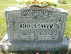
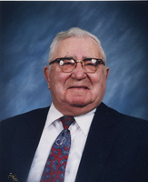
Mason John Rodeheaver
| Birth | : | 3 Aug 1916 |
| Death | : | 13 Apr 2001 |
| Burial | : | Oak Grove Church of the Brethren Cemetery, McHenry, Garrett County, USA |
| Coordinate | : | 39.5694400, -79.3834300 |
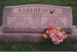
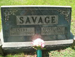
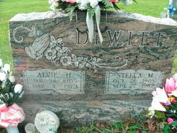
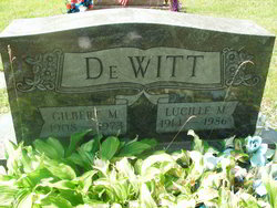
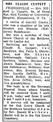
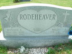
| Description | : | Mason J. Rodeheaver, 84, Friendsville, died Friday, April 13, 2001, at Cuppett-Weeks Nursing Home, Oakland. Born Aug. 3, 1916, in Friendsville, he was a son of the late Andrew and Blanche (Matthews) Rodeheaver. He was also preceded in death by his wife, Geraldine (Wright) Rodeheaver, on Nov. 20, 1998; one son, Donald Rodeheaver; two brothers, Hobert Rodeheaver and James Rodeheaver; and four sisters, Mary Savage, Stella DeWitt, Mildred Cuppett, and Lucille DeWitt. He was a lifelong farmer and worked in construction and for the Penn Line Service for a number of years. He was a member of the Oak Grove... Read More |
frequently asked questions (FAQ):
-
Where is Mason John Rodeheaver's memorial?
Mason John Rodeheaver's memorial is located at: Oak Grove Church of the Brethren Cemetery, McHenry, Garrett County, USA.
-
When did Mason John Rodeheaver death?
Mason John Rodeheaver death on 13 Apr 2001 in
-
Where are the coordinates of the Mason John Rodeheaver's memorial?
Latitude: 39.5694400
Longitude: -79.3834300
Family Members:
Parent

Spouse

Siblings

Children
Flowers:


Nearby Cemetories:
1. Oak Grove Church of the Brethren Cemetery
McHenry, Garrett County, USA
Coordinate: 39.5694400, -79.3834300
2. Hoye Family Cemetery - Crab Tree Bottom
McHenry, Garrett County, USA
Coordinate: 39.5642220, -79.3855000
3. Saint Dominic Catholic Cemetery
Hoyes, Garrett County, USA
Coordinate: 39.5868300, -79.3698600
4. Hoyes Cemetery
Garrett County, USA
Coordinate: 39.5905991, -79.3683014
5. Upper Sang Run Cemetery
McHenry, Garrett County, USA
Coordinate: 39.5717810, -79.4242430
6. Flatwood Cemetery
Accident, Garrett County, USA
Coordinate: 39.5923500, -79.3515400
7. Skiles Cemetery
Accident, Garrett County, USA
Coordinate: 39.5971570, -79.3439160
8. Bumblebee Ridge Cemetery
McHenry, Garrett County, USA
Coordinate: 39.5774400, -79.3296800
9. Hoyes Run Cemetery
Garrett County, USA
Coordinate: 39.5313100, -79.4110900
10. Bray Cemetery
Oakland, Garrett County, USA
Coordinate: 39.5006900, -79.3858100
11. Glotfelty Farm Cemetery
McHenry, Garrett County, USA
Coordinate: 39.5708800, -79.2905500
12. Bear Creek Church of the Brethren Cemetery
Accident, Garrett County, USA
Coordinate: 39.6213000, -79.3099800
13. Saint Paul's Old Cemetery
Accident, Garrett County, USA
Coordinate: 39.6287100, -79.3182100
14. Friend Cemetery
Oakland, Garrett County, USA
Coordinate: 39.4913500, -79.3778000
15. Ruckle Family Cemetery
Bittinger, Garrett County, USA
Coordinate: 39.5802600, -79.2821900
16. Cherry Glade Cemetery
Accident, Garrett County, USA
Coordinate: 39.5827200, -79.2799500
17. Glade Mennonite Cemetery
Bittinger, Garrett County, USA
Coordinate: 39.5826300, -79.2796700
18. Zion Lutheran Cemetery
Accident, Garrett County, USA
Coordinate: 39.6300510, -79.3129020
19. Taylor-Sines Cemetery
Oakland, Garrett County, USA
Coordinate: 39.4894470, -79.4165480
20. Lake Ford Cemetery
Garrett County, USA
Coordinate: 39.5278015, -79.4792023
21. Cranesville Cemetery
Cranesville, Preston County, USA
Coordinate: 39.5543920, -79.4929870
22. Glendale Cemetery
Oakland, Garrett County, USA
Coordinate: 39.5085983, -79.2953033
23. Rodeheaver Cemetery
Oakland, Garrett County, USA
Coordinate: 39.4804680, -79.3521300
24. Sisler Cemetery
Mountain Dale, Preston County, USA
Coordinate: 39.6081009, -79.4938965