
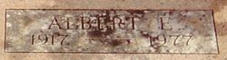

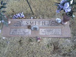
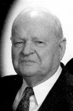
Albert Elton Smith
| Birth | : | 18 Oct 1917 Burlingame, Osage County, Kansas, USA |
| Death | : | 22 Nov 1977 Burlingame Township, Osage County, Kansas, USA |
| Burial | : | Randolph Cemetery, Columbia, Richland County, USA |
| Coordinate | : | 34.0093500, -81.0540800 |
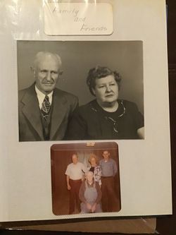
| Description | : | Topeka Daily Capital, Wednesday, Nov. 23, 1977,page 19: Albert E. Smith Burlingame --- Albert E. Smith, 60, Route 2, Burlingame, died Tuesday at his home northwest of here. He apparently had a heart attack. He was born Oct. 18, 1917, at Burlingame and spent his life in the Burlingame community. He worked at the Topeka Supply Depot until 1957 and was a farmer many years. He was married to Betty Riggin Oct. 18, 1941, at Lyndon. She survives. Other survivors include two sons, Ronald Smith, Burlingame, and Robert Smith, Osage City; a daughter, Mrs. Charlene Fry,... Read More |
frequently asked questions (FAQ):
-
Where is Albert Elton Smith's memorial?
Albert Elton Smith's memorial is located at: Randolph Cemetery, Columbia, Richland County, USA.
-
When did Albert Elton Smith death?
Albert Elton Smith death on 22 Nov 1977 in Burlingame Township, Osage County, Kansas, USA
-
Where are the coordinates of the Albert Elton Smith's memorial?
Latitude: 34.0093500
Longitude: -81.0540800
Family Members:
Parent
Spouse
Siblings
Children
Flowers:


Nearby Cemetories:
1. Randolph Cemetery
Columbia, Richland County, USA
Coordinate: 34.0093500, -81.0540800
2. Lower Cemetery
Columbia, Richland County, USA
Coordinate: 34.0093900, -81.0571990
3. Elmwood Memorial Gardens
Columbia, Richland County, USA
Coordinate: 34.0121000, -81.0523200
4. Saint Peter's Cemetery
Columbia, Richland County, USA
Coordinate: 34.0119200, -81.0488700
5. Douglass Cemetery
Columbia, Richland County, USA
Coordinate: 34.0180340, -81.0492810
6. Hebrew Benevolent Society Cemetery
Columbia, Richland County, USA
Coordinate: 34.0049780, -81.0435680
7. Saint Peter's Catholic Church Cemetery
Columbia, Richland County, USA
Coordinate: 34.0052900, -81.0384100
8. Ebenezer Lutheran Church Cemetery
Columbia, Richland County, USA
Coordinate: 34.0113680, -81.0361220
9. Mount Pleasant United Methodist Church Cemetery
Columbia, Richland County, USA
Coordinate: 34.0101996, -81.0350037
10. Geiger Avenue Cemetery
Columbia, Richland County, USA
Coordinate: 34.0228050, -81.0394590
11. First Baptist Church Cemetery
Columbia, Richland County, USA
Coordinate: 34.0062460, -81.0321850
12. Church of the Good Shepherd Memorial Gardens
Columbia, Richland County, USA
Coordinate: 34.0096610, -81.0316160
13. First Presbyterian Churchyard
Columbia, Richland County, USA
Coordinate: 34.0041110, -81.0293900
14. Miller Cemetery
Columbia, Richland County, USA
Coordinate: 34.0321999, -81.0391998
15. Fridig Cemetery
Lexington County, USA
Coordinate: 33.9961600, -81.0836350
16. Saint Lukes Episcopal Church Memorial Garden
Columbia, Richland County, USA
Coordinate: 34.0082060, -81.0180940
17. Colored Asylum Cemetery
Columbia, Richland County, USA
Coordinate: 34.0244050, -81.0220490
18. All Saints Episcopal Church Garden
Cayce, Lexington County, USA
Coordinate: 33.9810790, -81.0695250
19. Barhamville Cemetery
Columbia, Richland County, USA
Coordinate: 34.0236870, -81.0107570
20. Granby Gardens Park Pavilion Cemetery
Cayce, Lexington County, USA
Coordinate: 33.9712890, -81.0677060
21. Lincoln Cemetery
Columbia, Richland County, USA
Coordinate: 34.0400009, -81.0214005
22. Olympia Cemetery
Columbia, Richland County, USA
Coordinate: 33.9719009, -81.0325012
23. Cayce Burial Gnd
Cayce, Lexington County, USA
Coordinate: 33.9693510, -81.0675840
24. Earl Cemetery
Cayce, Lexington County, USA
Coordinate: 33.9677560, -81.0646100