
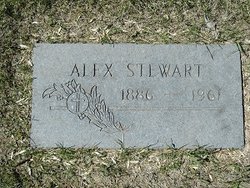
Alexander Daniel “Alex” Stewart
| Birth | : | 1 Sep 1889 Holdingford, Stearns County, Minnesota, USA |
| Death | : | 5 Oct 1961 Havre, Hill County, Montana, USA |
| Burial | : | Calvary Cemetery, Havre, Hill County, USA |
| Coordinate | : | 48.5457000, -109.6883000 |
| Plot | : | Space C, Lot 27, Block 16 |
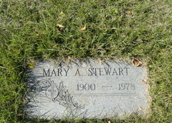
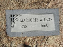
| Description | : | Alex Stewart, 72, retired farmer died at his home Thursday. Mr. Stewart was born on Sept. 1, 1889 in Holdingford, Minn. He moved to Havre eight years ago from the homestead where he had lived since 1910, 10 miles south of Kremlin. His widow Mary survives, and is at her home at 621 First Avenue. The couple was married on October 28, 1928. Children surviving him are Mrs. Alvin (Marjorie) Wilson, Lloyd; Mrs. John (Agnes) Deppel. Butte; Mrs. Robert (Jean) Whitemore, Great Falls; James Stewart, Havre; Mrs. Carl (Ursuline) Stoynoff, Leavenworth, Kan.; Mrs.Ben (Kathryn) Rosey, Fairbanks, Alaska; and Mrs.... Read More |
frequently asked questions (FAQ):
-
Where is Alexander Daniel “Alex” Stewart's memorial?
Alexander Daniel “Alex” Stewart's memorial is located at: Calvary Cemetery, Havre, Hill County, USA.
-
When did Alexander Daniel “Alex” Stewart death?
Alexander Daniel “Alex” Stewart death on 5 Oct 1961 in Havre, Hill County, Montana, USA
-
Where are the coordinates of the Alexander Daniel “Alex” Stewart's memorial?
Latitude: 48.5457000
Longitude: -109.6883000
Family Members:
Spouse
Children

Flowers:


Nearby Cemetories:
1. Calvary Cemetery
Havre, Hill County, USA
Coordinate: 48.5457000, -109.6883000
2. Highland Cemetery
Havre, Hill County, USA
Coordinate: 48.5463982, -109.6900024
3. Mount Hope Cemetery
Havre, Hill County, USA
Coordinate: 48.5540000, -109.7050000
4. Sunset Garden Park
Havre, Hill County, USA
Coordinate: 48.5531006, -109.8019028
5. North Havre Lutheran Church Graveyard (Defunct)
Havre, Hill County, USA
Coordinate: 48.6538903, -109.6815870
6. Grainbelt Cemetery
Hill County, USA
Coordinate: 48.6828003, -109.8657990
7. Andrew S. Lohman Grave Site
Lohman, Blaine County, USA
Coordinate: 48.5903520, -109.4073350
8. East End Colony Cemetery
East End Colony, Hill County, USA
Coordinate: 48.7485000, -109.5474000
9. Hilldale Hutterite Colony Cemetery
Hilldale Colony, Hill County, USA
Coordinate: 48.7997000, -109.7872000
10. Saint Johns Catholic Cemetery
Havre, Hill County, USA
Coordinate: 48.7625008, -109.9638977
11. Saint Gabriel Cemetery
Chinook, Blaine County, USA
Coordinate: 48.6065200, -109.2531200
12. Kuper Memorial Cemetery
Chinook, Blaine County, USA
Coordinate: 48.6083100, -109.2531200
13. Rocky Boy Cemetery
Rocky Boy, Hill County, USA
Coordinate: 48.2572410, -109.7923690
14. Box Elder Cemetery
Box Elder, Hill County, USA
Coordinate: 48.3274000, -110.0095000
15. Rocky Boy Gravel Cemetery
Rocky Boy, Hill County, USA
Coordinate: 48.2427720, -109.7596500
16. Cottonwood Lutheran Church Cemetery
Havre, Hill County, USA
Coordinate: 48.4545000, -110.1748000
17. Bear Paw Battlefield
Chinook, Blaine County, USA
Coordinate: 48.3780070, -109.2121290
18. Hungry Hollow Cemetery
Blaine County, USA
Coordinate: 48.2103004, -109.4677963
19. Milk River Valley Church Graveyard
Hill County, USA
Coordinate: 48.6787180, -110.2261080
20. Hollandville Cemetery
Chinook, Blaine County, USA
Coordinate: 48.6960310, -109.1557200
21. Gildford Hill County Cemetery
Gildford, Hill County, USA
Coordinate: 48.5778008, -110.2957993
22. Prairie Chapel United Brethren Cemetery
Chinook, Blaine County, USA
Coordinate: 48.8860000, -109.3414000
23. Mennonite Brethren Cemetery
Chinook, Blaine County, USA
Coordinate: 48.8012560, -109.1980620
24. Bethel Bruderthaler Mennonite Church Cemetery
Chinook, Blaine County, USA
Coordinate: 48.7552000, -109.1345000