
| Birth | : | 31 Mar 1930 Volga, Clayton County, Iowa, USA |
| Death | : | 24 Jul 2015 Independence, Buchanan County, Iowa, USA |
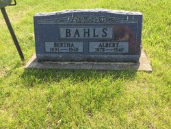
| Burial | : | Guttenberg Cemetery, Guttenberg, Clayton County, USA |
| Coordinate | : | 42.7691994, -91.1035995 |
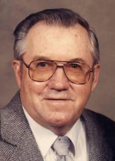
| Description | : | Alfred Elmer Bahls, age 85, of Guttenberg, IA, died Friday, July 24, 2015, at the Buchanan County Health Center in Independence, IA. He was born on March 31, 1930 in the Volga Township in Clayton County Iowa to Albert and Bertha (Behens) Bahls. Alfred received his education from the Guttenberg School system where he graduated with the class of 1948. Days after graduation, Alfred entered the U.S. Navy where he served his country during Korean War and was honorably discharged on May 2, 1952. Five months later, Alfred was united in marriage with Darlene Schroeder on October 14, 1952, at... Read More |
frequently asked questions (FAQ):
-
Where is Alfred Elmer Bahls's memorial?
Alfred Elmer Bahls's memorial is located at: Guttenberg Cemetery, Guttenberg, Clayton County, USA.
-
When did Alfred Elmer Bahls death?
Alfred Elmer Bahls death on 24 Jul 2015 in Independence, Buchanan County, Iowa, USA
-
Where are the coordinates of the Alfred Elmer Bahls's memorial?
Latitude: 42.7691994
Longitude: -91.1035995
Family Members:
Parent

Spouse

Siblings
Children
Flowers:


Nearby Cemetories:
1. Guttenberg Cemetery
Guttenberg, Clayton County, USA
Coordinate: 42.7691994, -91.1035995
2. Mount Olivet Cemetery
Guttenberg, Clayton County, USA
Coordinate: 42.7764840, -91.1083560
3. Saint Johns Cemetery
Jefferson Township, Clayton County, USA
Coordinate: 42.7497000, -91.1133000
4. Saint Marys Cemetery
Guttenberg, Clayton County, USA
Coordinate: 42.7691994, -91.1352997
5. Old Saint Marys Cemetery
Glen Haven, Grant County, USA
Coordinate: 42.8078100, -91.0675330
6. Bierer Cemetery
Millville, Clayton County, USA
Coordinate: 42.7230500, -91.0925166
7. Charlotte Cemetery
Glen Haven, Grant County, USA
Coordinate: 42.7933006, -91.0381012
8. Redman Cemetery
Millville, Clayton County, USA
Coordinate: 42.7166755, -91.0852901
9. Borcherding Cemetery
Jefferson Township, Clayton County, USA
Coordinate: 42.8182983, -91.1414032
10. Storck Cemetery
Guttenberg, Clayton County, USA
Coordinate: 42.7694335, -91.1834638
11. Friedlein Cemetery
Millville, Clayton County, USA
Coordinate: 42.7080994, -91.1108017
12. Lewis Cemetery
Osterdock, Clayton County, USA
Coordinate: 42.7416000, -91.1834000
13. Saint Michael Cemetery
Clayton County, USA
Coordinate: 42.8055992, -91.1802979
14. Duncan Cemetery
Glen Haven, Grant County, USA
Coordinate: 42.8325540, -91.0725940
15. Saint Paula Cemetery
Osterdock, Clayton County, USA
Coordinate: 42.7635994, -91.1992035
16. Gockel Cemetery
Glen Haven, Grant County, USA
Coordinate: 42.8224983, -91.0385971
17. Ramsey Cemetery
North Andover, Grant County, USA
Coordinate: 42.7817001, -90.9972000
18. Bethel Cemetery
Osterdock, Clayton County, USA
Coordinate: 42.7041702, -91.1688919
19. Pioneer Rock Cemetery
Ceres, Clayton County, USA
Coordinate: 42.8230591, -91.1863937
20. Goshen Cemetery
Millville, Clayton County, USA
Coordinate: 42.6905594, -91.0544434
21. Scott Cemetery
Glen Haven, Grant County, USA
Coordinate: 42.8368988, -91.0299988
22. Graham Cemetery
Millville, Clayton County, USA
Coordinate: 42.6833172, -91.1195685
23. Tangeman Family Cemetery
Garnavillo, Clayton County, USA
Coordinate: 42.8580000, -91.1420000
24. McClelland Cemetery
Garnavillo, Clayton County, USA
Coordinate: 42.8249879, -91.2084641