
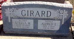

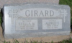
Alfred Treffly “Fritz” Girard
| Birth | : | 5 Sep 1906 Clifton, Washington County, Kansas, USA |
| Death | : | 13 Feb 1980 Concordia, Cloud County, Kansas, USA |
| Burial | : | Saint Joseph Cemetery, Saint Joseph, Cloud County, USA |
| Coordinate | : | 39.5074941, -97.4022328 |
| Description | : | Alfred "Fritz" Girard was born September 5, 1906, at Clifton, Kansas. He died at St. Joseph Hospital, Concordia. He was a lifetime resident of the Clyde community and a member of the Catholic Church. He farmed much of his life, then became an engineer for Standard Oil Co. He retired in 1966. He served in the U.S. Navy in World War II. He was a member of the Clyde Veterans of Foreign Wars post and the Clifton American Legion. Survivors included three daughters, Mrs. Lucille Tremblay, Mrs. Lorena Ashley, and Mrs. Joan Hamel; five sons, Leland, Raymond, LaVern, Lawrence James and... Read More |
frequently asked questions (FAQ):
-
Where is Alfred Treffly “Fritz” Girard's memorial?
Alfred Treffly “Fritz” Girard's memorial is located at: Saint Joseph Cemetery, Saint Joseph, Cloud County, USA.
-
When did Alfred Treffly “Fritz” Girard death?
Alfred Treffly “Fritz” Girard death on 13 Feb 1980 in Concordia, Cloud County, Kansas, USA
-
Where are the coordinates of the Alfred Treffly “Fritz” Girard's memorial?
Latitude: 39.5074941
Longitude: -97.4022328
Family Members:
Parent
Spouse

Siblings
Children

Flowers:


Nearby Cemetories:
1. Saint Joseph Cemetery
Saint Joseph, Cloud County, USA
Coordinate: 39.5074941, -97.4022328
2. Pleasant View Cemetery
Ames, Cloud County, USA
Coordinate: 39.5346985, -97.4431000
3. Cedar Grove Cemetery
Clyde, Cloud County, USA
Coordinate: 39.5494003, -97.4056015
4. Iwacura Cemetery
Morganville, Clay County, USA
Coordinate: 39.4550000, -97.3510000
5. French Presbyterian Church Cemetery
Cloud County, USA
Coordinate: 39.4395200, -97.4148290
6. Green Mound Cemetery
Rice, Cloud County, USA
Coordinate: 39.5248450, -97.5081630
7. Riverdale Cemetery
Clay County, USA
Coordinate: 39.5106010, -97.2930984
8. Mount Calvary Cemetery
Clyde, Cloud County, USA
Coordinate: 39.5917015, -97.4143982
9. Princeville Cemetery
Aurora, Cloud County, USA
Coordinate: 39.4672012, -97.5010986
10. Mount Hope Cemetery
Clyde, Cloud County, USA
Coordinate: 39.5969009, -97.4116974
11. Saint Peters Cemetery
Aurora, Cloud County, USA
Coordinate: 39.4763985, -97.5180969
12. Walnut Grove Cemetery
Cloud County, USA
Coordinate: 39.5699997, -97.4993973
13. Nelson Cemetery
Rice, Cloud County, USA
Coordinate: 39.5257988, -97.5410995
14. Bloom Cemetery
Morganville, Clay County, USA
Coordinate: 39.4519005, -97.2778015
15. Lincoln Cemetery
Clay Center, Clay County, USA
Coordinate: 39.4230995, -97.2930984
16. Sulphur Springs Cemetery
Aurora, Cloud County, USA
Coordinate: 39.4086610, -97.4986840
17. Rice Cemetery
Rice, Cloud County, USA
Coordinate: 39.5614014, -97.5552979
18. Sherman Cemetery
Morganville, Clay County, USA
Coordinate: 39.5316300, -97.2243700
19. Smith Grave
Miltonvale, Cloud County, USA
Coordinate: 39.3645300, -97.4308700
20. Hollis Cemetery
Cloud County, USA
Coordinate: 39.6383018, -97.5361023
21. Norwegian Lutheran Cemetery
Clay Center, Clay County, USA
Coordinate: 39.5027900, -97.1828200
22. Agenda Cemetery
Agenda, Republic County, USA
Coordinate: 39.6761017, -97.4336014
23. Morganville City Cemetery
Morganville, Clay County, USA
Coordinate: 39.4733009, -97.1819000
24. Miltonvale Cemetery
Miltonvale, Cloud County, USA
Coordinate: 39.3358002, -97.4447021