
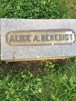


Alice A. Rees Benedict
| Birth | : | Jan 1857 |
| Death | : | 7 May 1943 Ohio, USA |
| Burial | : | St. Mary's Churchyard, Mellor, Ribble Valley Borough, England |
| Coordinate | : | 53.7728600, -2.5312400 |
| Plot | : | Section 1, Lot 20 |
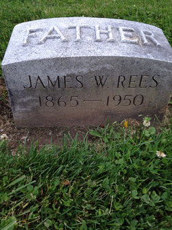
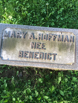
| Description | : | Wife of Frank C. Mother of Mary Ann HOFFMAN. Daughter of James and Mary Ann Orchard Rees. Sister of James, George and Mary Ann. Name: Benedict, Alice A. Date: May 7 1943 Id#: 0021697 Source: Source unknown; Cleveland Necrology File, Reel #006. Notes: Benedict: Alice A. (nee Rose), wife of the late Frank C., mother of the late Mary A. Hoffman, sister of James Rees. Friends may call at the Duke Eyler Funeral Home, 4466 Pearl rd., until Saturday morning. Services at 2:30 p. m., Saturday, May 8, at the Donald B. Johnson Funeral Home, 521 Broadway. Bedford. Interment Bedford Cemetery. |
frequently asked questions (FAQ):
-
Where is Alice A. Rees Benedict's memorial?
Alice A. Rees Benedict's memorial is located at: St. Mary's Churchyard, Mellor, Ribble Valley Borough, England.
-
When did Alice A. Rees Benedict death?
Alice A. Rees Benedict death on 7 May 1943 in Ohio, USA
-
Where are the coordinates of the Alice A. Rees Benedict's memorial?
Latitude: 53.7728600
Longitude: -2.5312400
Family Members:
Parent
Spouse

Siblings
Children
Flowers:


Nearby Cemetories:
1. St. Mary's Churchyard
Mellor, Ribble Valley Borough, England
Coordinate: 53.7728600, -2.5312400
2. Mellor Methodist Churchyard
Blackburn, Blackburn with Darwen Unitary Authority, England
Coordinate: 53.7742950, -2.5255060
3. St Mary's R.C. Church Cemetery
Osbaldeston, Ribble Valley Borough, England
Coordinate: 53.7816970, -2.5350240
4. St Leonard Churchyard
Balderstone, Ribble Valley Borough, England
Coordinate: 53.7860070, -2.5609380
5. St Peter Churchyard
Salesbury, Ribble Valley Borough, England
Coordinate: 53.7915000, -2.4859100
6. Pleasington Cemetery and Crematorium
Blackburn, Blackburn with Darwen Unitary Authority, England
Coordinate: 53.7388880, -2.5368710
7. St Paul's
Blackburn, Blackburn with Darwen Unitary Authority, England
Coordinate: 53.7491222, -2.4891266
8. Blackburn Cemetery
Blackburn, Blackburn with Darwen Unitary Authority, England
Coordinate: 53.7662430, -2.4726050
9. St Wilfrid Churchyard
Ribchester, Ribble Valley Borough, England
Coordinate: 53.8102780, -2.5332650
10. Wesleyan Methodist Chapel Chapelyard
Blackburn, Blackburn with Darwen Unitary Authority, England
Coordinate: 53.7464910, -2.4848380
11. Independent Chapel Churchyard
Blackburn, Blackburn with Darwen Unitary Authority, England
Coordinate: 53.7454960, -2.4864460
12. St. Peter's Churchyard
Blackburn, Blackburn with Darwen Unitary Authority, England
Coordinate: 53.7448110, -2.4865070
13. Pleasington Priory
Pleasington, Blackburn with Darwen Unitary Authority, England
Coordinate: 53.7348590, -2.5433060
14. Blackburn Cathedral
Blackburn, Blackburn with Darwen Unitary Authority, England
Coordinate: 53.7472960, -2.4820020
15. St Alban's Churchyard
Blackburn, Blackburn with Darwen Unitary Authority, England
Coordinate: 53.7530090, -2.4748540
16. Holy Trinity Church
Blackburn with Darwen Unitary Authority, England
Coordinate: 53.7511727, -2.4747178
17. Mount St Presbyterian Chapelyard
Blackburn, Blackburn with Darwen Unitary Authority, England
Coordinate: 53.7478000, -2.4775000
18. The Church of St. Saviour The Holy House of Stydd
Ribchester, Ribble Valley Borough, England
Coordinate: 53.8188690, -2.5272770
19. St. Josephs Roman Catholic Churchyard
Brindle, Chorley Borough, England
Coordinate: 53.7350780, -2.5880640
20. St. Mary's and St. John RC Churchyard, Southworth
Samlesbury, South Ribble Borough, England
Coordinate: 53.7676690, -2.6183400
21. New Row Methodist Church
Blackburn with Darwen Unitary Authority, England
Coordinate: 53.7208950, -2.5023720
22. St. Leonard the Less Churchyard
Samlesbury, South Ribble Borough, England
Coordinate: 53.7680000, -2.6237000
23. Holy Trinity Churchyard
Hoghton, Chorley Borough, England
Coordinate: 53.7279300, -2.5848550
24. Our Lady and St. Michael Roman Catholic Churchyard
Longridge, Ribble Valley Borough, England
Coordinate: 53.8088040, -2.6133470