
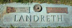
Alice Butler Landreth
| Birth | : | 11 Apr 1888 Laurens County, South Carolina, USA |
| Death | : | 17 Jun 1961 Laurens, Laurens County, South Carolina, USA |
| Burial | : | Kent and Sussex Cemetery and Crematorium, Royal Tunbridge Wells, Tunbridge Wells Borough, England |
| Coordinate | : | 51.1173720, 0.2740330 |
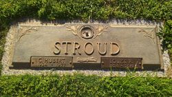
| Description | : | Mrs. Alice Butler Landreth, 73, native of Laurens County, died at a Laurens hospital at 1:35 a.m. Saturday (June 17, 1961). Mrs. Landreth made her home in the Barksdale community and was a charter member and the oldest member of Welcome Baptist Church. Her husband, William Arthur Landreth, died in 1952. She was a daughter of the late Robert and Adeline Brice Butler. Surviving are two daughters, Mrs. Charlie L. Rhew and Mrs. C. Hubert Stroud; two granddaughters (foster daughters), Mrs. E.W. Grubbs and Mrs. Horace Massey; one grandson, four great-grandchildren, and two sisters, Mrs. George Webb and... Read More |
frequently asked questions (FAQ):
-
Where is Alice Butler Landreth's memorial?
Alice Butler Landreth's memorial is located at: Kent and Sussex Cemetery and Crematorium, Royal Tunbridge Wells, Tunbridge Wells Borough, England.
-
When did Alice Butler Landreth death?
Alice Butler Landreth death on 17 Jun 1961 in Laurens, Laurens County, South Carolina, USA
-
Where are the coordinates of the Alice Butler Landreth's memorial?
Latitude: 51.1173720
Longitude: 0.2740330
Family Members:
Spouse

Children
Flowers:


Nearby Cemetories:
1. Kent and Sussex Cemetery and Crematorium
Royal Tunbridge Wells, Tunbridge Wells Borough, England
Coordinate: 51.1173720, 0.2740330
2. Trinity Churchyard
Royal Tunbridge Wells, Tunbridge Wells Borough, England
Coordinate: 51.1328200, 0.2623600
3. St. Alban's Churchyard
Frant, Wealden District, England
Coordinate: 51.0980580, 0.2698300
4. Hanover Strict Baptist Chapel
Royal Tunbridge Wells, Tunbridge Wells Borough, England
Coordinate: 51.1356700, 0.2625100
5. Woodbury Park Cemetery
Royal Tunbridge Wells, Tunbridge Wells Borough, England
Coordinate: 51.1389847, 0.2637900
6. St John's Church
Royal Tunbridge Wells, Tunbridge Wells Borough, England
Coordinate: 51.1402330, 0.2608070
7. St. Paul's Churchyard
Rusthall, Tunbridge Wells Borough, England
Coordinate: 51.1307144, 0.2376710
8. Holy Trinity Churchyard
Eridge Green, Wealden District, England
Coordinate: 51.0989300, 0.2232190
9. Pembury Burial Ground
Pembury, Tunbridge Wells Borough, England
Coordinate: 51.1416270, 0.3229290
10. St Paul New Churchyard
Rusthall, Tunbridge Wells Borough, England
Coordinate: 51.1401520, 0.2204420
11. Southborough Cemetery
Southborough, Tunbridge Wells Borough, England
Coordinate: 51.1592860, 0.2420140
12. St Peter's New Churchyard
Pembury, Tunbridge Wells Borough, England
Coordinate: 51.1506200, 0.3269600
13. All Saints Churchyard
Langton Green, Tunbridge Wells Borough, England
Coordinate: 51.1309738, 0.2022060
14. St. Peter's Churchyard
Southborough, Tunbridge Wells Borough, England
Coordinate: 51.1626549, 0.2520690
15. St. Mary the Virgin Churchyard
Speldhurst, Tunbridge Wells Borough, England
Coordinate: 51.1510790, 0.2198230
16. Southborough War Memorial
Southborough, Tunbridge Wells Borough, England
Coordinate: 51.1639214, 0.2528920
17. Bayham Old Abbey
Lamberhurst, Tunbridge Wells Borough, England
Coordinate: 51.1032690, 0.3541800
18. St. Lawrence Churchyard
Bidborough, Tunbridge Wells Borough, England
Coordinate: 51.1666950, 0.2371870
19. Old Churchyard of St Peter
Pembury, Tunbridge Wells Borough, England
Coordinate: 51.1629330, 0.3241620
20. St John the Evangelist Churchyard
Groombridge, Wealden District, England
Coordinate: 51.1179771, 0.1854370
21. St. Luke's Churchyard
Matfield, Tunbridge Wells Borough, England
Coordinate: 51.1426588, 0.3626785
22. All Souls Churchyard
Poundsbridge, Sevenoaks District, England
Coordinate: 51.1540700, 0.1961470
23. St. Peter's Churchyard
Fordcombe, Sevenoaks District, England
Coordinate: 51.1422043, 0.1792730
24. St. Peter & St. Paul Churchyard
Wadhurst, Wealden District, England
Coordinate: 51.0626960, 0.3400690