
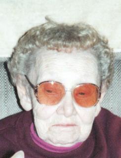

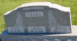
Alo M Morarend Taake
| Birth | : | 14 Sep 1917 Guttenberg, Clayton County, Iowa, USA |
| Death | : | 30 Apr 2005 Guttenberg, Clayton County, Iowa, USA |
| Burial | : | Posbrook Lane Cemetery, Titchfield, Fareham Borough, England |
| Coordinate | : | 50.8463100, -1.2403000 |
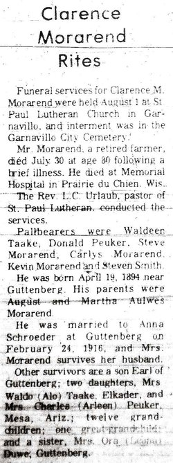
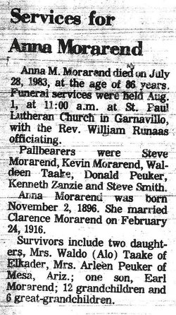
| Description | : | Alo M. Taake, 87, of rural Elkader, died Saturday, April 30, 2005, at the Guttenberg Municipal Hospital, following a long illness. She was born September 14, 1917, in rural Guttenberg to Clarence and Anna (Schroeder) Morarend. She was united in marriage to Waldo Taake on November 17, 1937, at Zion Lutheran Church in Clayton Center. Four children were born to this union. They farmed and made their home where she continued to reside until her death. Alo was a member of Zion Lutheran Church and its Ladies Aid, Farm Bureau organizations and the Readlanders Club. She enjoyed embroidery, cooking, baking,... Read More |
frequently asked questions (FAQ):
-
Where is Alo M Morarend Taake's memorial?
Alo M Morarend Taake's memorial is located at: Posbrook Lane Cemetery, Titchfield, Fareham Borough, England.
-
When did Alo M Morarend Taake death?
Alo M Morarend Taake death on 30 Apr 2005 in Guttenberg, Clayton County, Iowa, USA
-
Where are the coordinates of the Alo M Morarend Taake's memorial?
Latitude: 50.8463100
Longitude: -1.2403000
Family Members:
Parent
Spouse
Siblings

Flowers:


Nearby Cemetories:
1. Posbrook Lane Cemetery
Titchfield, Fareham Borough, England
Coordinate: 50.8463100, -1.2403000
2. St. Peter's Churchyard
Titchfield, Fareham Borough, England
Coordinate: 50.8490620, -1.2330780
3. Crofton Cemetery
Stubbington, Fareham Borough, England
Coordinate: 50.8364160, -1.2173260
4. St Edmund Churchyard
Stubbington, Fareham Borough, England
Coordinate: 50.8345130, -1.2185160
5. Crofton Old Churchyard
Stubbington, Fareham Borough, England
Coordinate: 50.8344830, -1.2183660
6. St John's Cemetery
Locks Heath, Fareham Borough, England
Coordinate: 50.8608400, -1.2651570
7. St Mary Churchyard
Warsash, Fareham Borough, England
Coordinate: 50.8473220, -1.2910610
8. Holy Trinity Churchyard
Fareham, Fareham Borough, England
Coordinate: 50.8522480, -1.1834370
9. Holly Hill Cemetery
Sarisbury, Fareham Borough, England
Coordinate: 50.8678930, -1.2888890
10. Fareham Cemetery
Fareham, Fareham Borough, England
Coordinate: 50.8623050, -1.1795840
11. St Paul Churchyard
Sarisbury, Fareham Borough, England
Coordinate: 50.8756100, -1.2870670
12. St. Peter and St. Paul Churchyard
Fareham, Fareham Borough, England
Coordinate: 50.8556300, -1.1753200
13. Knowle Hospital Cemetery
Fareham, Fareham Borough, England
Coordinate: 50.8849120, -1.2043980
14. Lee-On-Solent Memorial
Lee-on-the-Solent, Gosport Borough, England
Coordinate: 50.8045110, -1.2068440
15. St Andrew the Apostle Churchyard
Hamble-le-Rice, Eastleigh Borough, England
Coordinate: 50.8589100, -1.3179090
16. St Mary the Virgin Churchyard
Gosport, Gosport Borough, England
Coordinate: 50.8112690, -1.1724800
17. St. Leonard Churchyard
Bursledon, Eastleigh Borough, England
Coordinate: 50.8850230, -1.3068370
18. Netley Military Cemetery
Netley, Eastleigh Borough, England
Coordinate: 50.8682632, -1.3317170
19. St Bartholomew Churchyard
Botley, Eastleigh Borough, England
Coordinate: 50.9048000, -1.2754000
20. St Nicholas Churchyard
Wickham, City of Winchester, England
Coordinate: 50.8994865, -1.1827040
21. Portchester Crematorium Gardens
Portchester, Fareham Borough, England
Coordinate: 50.8499680, -1.1382190
22. St Mary the Virgin Churchyard
Hound, Eastleigh Borough, England
Coordinate: 50.8762820, -1.3322160
23. St. Nicholas' Churchyard
Boarhunt, City of Winchester, England
Coordinate: 50.8709800, -1.1442000
24. St Thomas the Apostle Churchyard
Gosport, Gosport Borough, England
Coordinate: 50.8137570, -1.1484570