


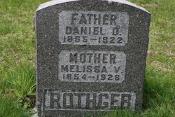
Alta Viola Rothgeb Gildow
| Birth | : | 14 Sep 1896 Perry, Noble County, Oklahoma, USA |
| Death | : | 13 Oct 1927 Langley, Island County, Washington, USA |
| Burial | : | Heath Lane Cemetery, Hemel Hempstead, Dacorum Borough, England |
| Coordinate | : | 51.7512350, -0.4785220 |
| Plot | : | West Side, Block 35, Lot 2 |
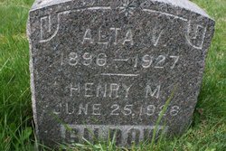
| Inscription | : | ALTA V. 1896 ~ 1927 HENRY M. JUNE 25, 1926 GILDOW |
frequently asked questions (FAQ):
-
Where is Alta Viola Rothgeb Gildow's memorial?
Alta Viola Rothgeb Gildow's memorial is located at: Heath Lane Cemetery, Hemel Hempstead, Dacorum Borough, England.
-
When did Alta Viola Rothgeb Gildow death?
Alta Viola Rothgeb Gildow death on 13 Oct 1927 in Langley, Island County, Washington, USA
-
Where are the coordinates of the Alta Viola Rothgeb Gildow's memorial?
Latitude: 51.7512350
Longitude: -0.4785220
Family Members:
Parent

Spouse
Siblings
Children

Flowers:


Nearby Cemetories:
1. Heath Lane Cemetery
Hemel Hempstead, Dacorum Borough, England
Coordinate: 51.7512350, -0.4785220
2. Hemel Hempstead War Memorial
Hemel Hempstead, Dacorum Borough, England
Coordinate: 51.7444960, -0.4772990
3. St John the Evangelist
Boxmoor, Dacorum Borough, England
Coordinate: 51.7444530, -0.4782000
4. Burma Star Association Memorial
Hemel Hempstead, Dacorum Borough, England
Coordinate: 51.7583610, -0.4727390
5. St. Mary's Churchyard
Hemel Hempstead, Dacorum Borough, England
Coordinate: 51.7590330, -0.4722730
6. St Mary's Church Apsley End
Apsley, Dacorum Borough, England
Coordinate: 51.7347710, -0.4659480
7. Holy Trinity Churchyard
Leverstock Green, Dacorum Borough, England
Coordinate: 51.7466800, -0.4295770
8. St. John the Evangelist Churchyard
Bourne End, Dacorum Borough, England
Coordinate: 51.7481590, -0.5296080
9. Woodwells Cemetery
Hemel Hempstead, Dacorum Borough, England
Coordinate: 51.7576500, -0.4280300
10. Kings Langley Priory
Kings Langley, Dacorum Borough, England
Coordinate: 51.7130000, -0.4603000
11. St Lawrence Churchyard
Bovingdon, Dacorum Borough, England
Coordinate: 51.7226750, -0.5292470
12. All Saints Churchyard
Kings Langley, Dacorum Borough, England
Coordinate: 51.7109030, -0.4479280
13. St. Michael and all Angels Churchyard
Berkhamsted, Dacorum Borough, England
Coordinate: 51.7590820, -0.5501120
14. Rectory Lane Cemetery
Berkhamsted, Dacorum Borough, England
Coordinate: 51.7577780, -0.5607880
15. Saint Peters Church
Berkhamsted, Dacorum Borough, England
Coordinate: 51.7595990, -0.5616600
16. St Lawrence the Martyr Churchyard
Abbots Langley, Three Rivers District, England
Coordinate: 51.7077650, -0.4170030
17. Kingshill Cemetery
Berkhamsted, Dacorum Borough, England
Coordinate: 51.7512770, -0.5743220
18. St. Mary's Churchyard
Redbourn, St Albans District, England
Coordinate: 51.7916200, -0.4066100
19. East Lane Cemetery
Leavesden, Three Rivers District, England
Coordinate: 51.7084796, -0.4036263
20. St. Paul Churchyard
Kings Langley, Dacorum Borough, England
Coordinate: 51.6931700, -0.4383900
21. St John the Evangelist Churchyard
Ashley Green, Chiltern District, England
Coordinate: 51.7374280, -0.5873140
22. Ashridge Priory
Little Gaddesden, Dacorum Borough, England
Coordinate: 51.7990000, -0.5600000
23. Baptist Chapel Burial Ground
Northchurch, Dacorum Borough, England
Coordinate: 51.7680500, -0.5895400
24. St. Mary's Churchyard
Northchurch, Dacorum Borough, England
Coordinate: 51.7697820, -0.5891900