
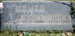
Alvie Nelson Thayer
| Birth | : | 30 Jun 1908 Nebraska, USA |
| Death | : | Mar 1968 USA |
| Burial | : | Little Shell Church Cemetery, New Town, Mountrail County, USA |
| Coordinate | : | 47.8317986, -102.4509246 |
| Description | : | Parents: Alvin and Pearl (Biltoft) Thayer. Husband of Mabel Elizabeth (Ostrander) Thayer. Married Aug. 16, 1930, in Hot Springs, S.D. |
frequently asked questions (FAQ):
-
Where is Alvie Nelson Thayer's memorial?
Alvie Nelson Thayer's memorial is located at: Little Shell Church Cemetery, New Town, Mountrail County, USA.
-
When did Alvie Nelson Thayer death?
Alvie Nelson Thayer death on Mar 1968 in USA
-
Where are the coordinates of the Alvie Nelson Thayer's memorial?
Latitude: 47.8317986
Longitude: -102.4509246
Family Members:
Parent

Spouse

Siblings
Flowers:


Nearby Cemetories:
1. Little Shell Church Cemetery
New Town, Mountrail County, USA
Coordinate: 47.8317986, -102.4509246
2. Holy Family US Scouts Cemetery
Sanish, Mountrail County, USA
Coordinate: 47.8101807, -102.5134048
3. Grand Valley Lutheran Cemetery
Sanish, Mountrail County, USA
Coordinate: 47.9222603, -102.5580444
4. Van Hook Cemetery
New Town, Mountrail County, USA
Coordinate: 47.9556045, -102.3660781
5. Saint Anthonys Cemetery
Mandaree, McKenzie County, USA
Coordinate: 47.7352300, -102.5972520
6. Saint Anthonys Cemetery
Halliday, Dunn County, USA
Coordinate: 47.7353249, -102.5976379
7. Independence Congregational Church Cemetery
Dunn County, USA
Coordinate: 47.6944300, -102.3767700
8. New Town Cemetery
New Town, Mountrail County, USA
Coordinate: 47.9838142, -102.4715881
9. Riverview Cemetery
New Town, Mountrail County, USA
Coordinate: 47.9944000, -102.5385971
10. Congregational Cemetery
Mandaree, McKenzie County, USA
Coordinate: 47.7315880, -102.6788450
11. Matthews Cemetery
Four Bears Village, McKenzie County, USA
Coordinate: 47.9489136, -102.6715164
12. Snowbird Cemetery
Mountrail County, USA
Coordinate: 47.9780540, -102.6517660
13. Goodbird Cemetery
McKenzie County, USA
Coordinate: 47.9768982, -102.6600037
14. Finstad Cemetery
Mountrail County, USA
Coordinate: 48.0374985, -102.3660965
15. Parshall Cemetery
Parshall, Mountrail County, USA
Coordinate: 47.9357200, -102.1282000
16. Memorial Congregational Church Cemetery
Raub, McLean County, USA
Coordinate: 47.7030900, -102.1339600
17. Saint Bridgets Cemetery
Parshall, Mountrail County, USA
Coordinate: 47.9622700, -102.1328910
18. Church of God Cemetery
Raub, McLean County, USA
Coordinate: 47.8041344, -102.0656662
19. Bethlehem Lutheran Cemetery
Belden, Mountrail County, USA
Coordinate: 48.0307007, -102.1838989
20. Our Redeemer Cemetery
McKenzie County, USA
Coordinate: 47.9644012, -102.8127975
21. Queen of Peace Cemetery
Raub, McLean County, USA
Coordinate: 47.7458000, -102.0532990
22. Bethesda Lutheran Church Cemetery
Raub, McLean County, USA
Coordinate: 47.7461800, -102.0486800
23. Union Cemetery
Johnsons Corner, McKenzie County, USA
Coordinate: 47.8302994, -102.8760986
24. Silent City Cemetery
Watford City, McKenzie County, USA
Coordinate: 47.8480988, -102.8778000