
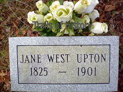
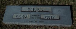
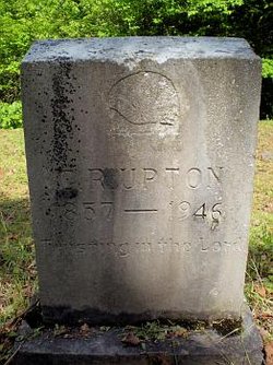
Amanda Jane West Upton
| Birth | : | Aug 1824 Rutherford County, North Carolina, USA |
| Death | : | 28 Dec 1901 Alarka, Swain County, North Carolina, USA |
| Burial | : | North Cemetery, Gill, Franklin County, USA |
| Coordinate | : | 42.6514160, -72.4817630 |
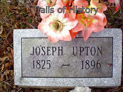
| Description | : | Amanda Jane West was the daughter of John West and Elizabeth "Betsy" Upton. Amanda married Joseph Crawford Upton on 19 Feb 1847 in the Tennessee Valley of Macon County, NC. Their marriage was performed by J.K. Gray, Clerk. The Alarka Community was a portion of Macon County at that time and later became a part of Swain County when it was formed in 1871. The current day "Jackson Line" Community of Swain County was the old boundary line between Jackson and Macon Counties. Jackson County was formed in 1851. Joseph and Amanda had 9-children: 1) Mary Elizabeth Upton 2) Samantha Jane... Read More |
frequently asked questions (FAQ):
-
Where is Amanda Jane West Upton's memorial?
Amanda Jane West Upton's memorial is located at: North Cemetery, Gill, Franklin County, USA.
-
When did Amanda Jane West Upton death?
Amanda Jane West Upton death on 28 Dec 1901 in Alarka, Swain County, North Carolina, USA
-
Where are the coordinates of the Amanda Jane West Upton's memorial?
Latitude: 42.6514160
Longitude: -72.4817630
Family Members:
Parent

Spouse
Siblings
Children
Flowers:


Nearby Cemetories:
1. North Cemetery
Gill, Franklin County, USA
Coordinate: 42.6514160, -72.4817630
2. Gill Center Cemetery
Gill, Franklin County, USA
Coordinate: 42.6413803, -72.4983063
3. Beers Ambush Gravesite
Northfield, Franklin County, USA
Coordinate: 42.6501200, -72.4560300
4. Mount Hermon Cemetery
Northfield, Franklin County, USA
Coordinate: 42.6790800, -72.4821100
5. West Gill Cemetery
Gill, Franklin County, USA
Coordinate: 42.6442700, -72.5280500
6. Northfield Farms Cemetery
Northfield, Franklin County, USA
Coordinate: 42.6124992, -72.4741974
7. Durkee Burial Lot
Northfield, Franklin County, USA
Coordinate: 42.6070000, -72.4861000
8. Saint Marys Cemetery
Northfield, Franklin County, USA
Coordinate: 42.6868910, -72.4448190
9. Center Cemetery
Northfield, Franklin County, USA
Coordinate: 42.6954308, -72.4613342
10. South Mountain Road Cemetery
Northfield, Franklin County, USA
Coordinate: 42.6375008, -72.4167023
11. Center Cemetery
Bernardston, Franklin County, USA
Coordinate: 42.6695213, -72.5498505
12. Pentecost Cemetery
Northfield, Franklin County, USA
Coordinate: 42.7010200, -72.4539900
13. Old Cemetery
Bernardston, Franklin County, USA
Coordinate: 42.6810989, -72.5444031
14. Riverside Cemetery
Gill, Franklin County, USA
Coordinate: 42.6156006, -72.5410995
15. West Northfield Cemetery
Northfield, Franklin County, USA
Coordinate: 42.7117004, -72.4689026
16. Greenfield Hebrew Congregation Cemetery
Greenfield, Franklin County, USA
Coordinate: 42.6409410, -72.5653360
17. Coller Cemetery
Northfield, Franklin County, USA
Coordinate: 42.6563988, -72.3930969
18. Round Top Cemetery
Northfield, Franklin County, USA
Coordinate: 42.7120600, -72.4447300
19. Log Plain Cemetery
Greenfield, Franklin County, USA
Coordinate: 42.6378320, -72.5725800
20. Holton Cemetery
Erving, Franklin County, USA
Coordinate: 42.5799500, -72.4634600
21. East Mineral Road Cemetery
Montague, Franklin County, USA
Coordinate: 42.5810500, -72.5086300
22. Erving Center Cemetery
Erving, Franklin County, USA
Coordinate: 42.6033300, -72.4056800
23. Highland Cemetery
Montague, Franklin County, USA
Coordinate: 42.5778008, -72.5083008
24. Diemand Family Cemetery
Wendell, Franklin County, USA
Coordinate: 42.5769900, -72.4520600