
| Birth | : | 26 May 1871 Iowa, USA |
| Death | : | 9 Jul 1939 Clayton County, Iowa, USA |
| Burial | : | St. Leonard's Churchyard, Padiham, Burnley Borough, England |
| Coordinate | : | 53.8022600, -2.3164300 |
| Plot | : | C-ROW-6-665 |
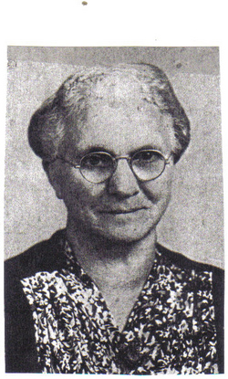
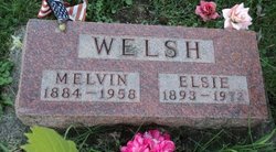
| Description | : | Family Memorial. CHILDREN; 1.ELSIE-SPOUSE;MELVIN WELSH 2.LUELLA-SPOUSE;J.PORTWINE 3.EARL-SPOUSE;FLORENCE KRUGER 4.FURMAN-SPOUSE;EVA BIDER 5.GRACE-SPOUSE;GEORGE LESTER 6.INEY-SPOUSE;E.WALLACE GRANDCHILDREN;1.JESS,GILBERT,DENNIS,DOROTHY,CECIL MILDRED,EDITH,MELVIN,ILLA 2.LLOYD,JOHN,BEULAH 3.HERBERT,MUREL,IRENE,THELMA,BEULAH 5.MARY,LEONA, BETTY,HENRY. GREATGRANDCHILDREN;JANICE,RODNEY,GEORGIA,CONNIE,AVA,CARLA DALE,NANCY,JOHN,PATTY,LAVERN,NORMA,GARY,PATRICK,KENNETH BONNIE,SHARON,KATHY,SANDRA,MELVA,ROBERTA,DELMAR,JAMES DARRELL,MONA,GWEN,RICHARD,BRUCE,FRANKLIN,MELVIN,EDWARDS FREDDY,MICHAEL,DEBRA,DOREN,GARY,CINDY,RHONDA,MARLA,CHARLES ANITA,ELSIE,DELORES,JULIA,GEORGE,DENNIS,DOUGLAS,KAREN,DAWN KEVIN,PAMELA,CARL. |
frequently asked questions (FAQ):
-
Where is Amos Hook's memorial?
Amos Hook's memorial is located at: St. Leonard's Churchyard, Padiham, Burnley Borough, England.
-
When did Amos Hook death?
Amos Hook death on 9 Jul 1939 in Clayton County, Iowa, USA
-
Where are the coordinates of the Amos Hook's memorial?
Latitude: 53.8022600
Longitude: -2.3164300
Family Members:
Parent

Spouse
Siblings
Children
Flowers:


Nearby Cemetories:
1. St. Leonard's Churchyard
Padiham, Burnley Borough, England
Coordinate: 53.8022600, -2.3164300
2. Wesleyan Methodist Chapel Chapelyard
Padiham, Burnley Borough, England
Coordinate: 53.8018980, -2.3181730
3. St Leonard Churchyard Extension
Padiham, Burnley Borough, England
Coordinate: 53.7991800, -2.3222000
4. St. John's Cemetery
Padiham, Burnley Borough, England
Coordinate: 53.7948720, -2.3145290
5. All Saints Churchyard
Habergham Eaves, Burnley Borough, England
Coordinate: 53.7971060, -2.2913770
6. St James Church
Altham, Hyndburn Borough, England
Coordinate: 53.7928940, -2.3465250
7. St Margaret Churchyard
Hapton, Burnley Borough, England
Coordinate: 53.7802400, -2.3169230
8. St. John's Churchyard
Read, Ribble Valley Borough, England
Coordinate: 53.8088800, -2.3585600
9. St John Churchyard
Higham, Pendle Borough, England
Coordinate: 53.8251420, -2.2898120
10. Burnley Cemetery
Burnley, Burnley Borough, England
Coordinate: 53.7821730, -2.2795070
11. Burnley Crematorium
Burnley, Burnley Borough, England
Coordinate: 53.7821730, -2.2795070
12. Saint Nicholas Parish Churchyard
Sabden, Ribble Valley Borough, England
Coordinate: 53.8346503, -2.3332764
13. Holy Trinity Churchyard
Burnley, Burnley Borough, England
Coordinate: 53.7898290, -2.2574200
14. St Marys Burial Ground
Clayton-le-Moors, Hyndburn Borough, England
Coordinate: 53.7792778, -2.3705871
15. St. Anne Churchyard
Fence, Pendle Borough, England
Coordinate: 53.8304372, -2.2679552
16. St. James' Churchyard
Burnley, Burnley Borough, England
Coordinate: 53.7905590, -2.2458280
17. Accrington Cemetery and Crematorium
Accrington, Hyndburn Borough, England
Coordinate: 53.7623787, -2.3508649
18. Ebenezer Baptist Chapel Chapelyard
Burnley, Burnley Borough, England
Coordinate: 53.7975120, -2.2397260
19. Wheatley Lane Methodist Churchyard
Fence, Pendle Borough, England
Coordinate: 53.8341457, -2.2596202
20. St. Peter's Churchyard
Burnley, Burnley Borough, England
Coordinate: 53.7924450, -2.2394890
21. Barnes Square Weslyan Methodist Churchyard
Clayton-le-Moors, Hyndburn Borough, England
Coordinate: 53.7744350, -2.3853800
22. All Saints Churchyard
Clayton-le-Moors, Hyndburn Borough, England
Coordinate: 53.7738520, -2.3881690
23. Our Lady and Saint Hubert
Great Harwood, Hyndburn Borough, England
Coordinate: 53.7851070, -2.4009760
24. St. Bartholomew's Churchyard
Great Harwood, Hyndburn Borough, England
Coordinate: 53.7900670, -2.4055460