
| Birth | : | 26 Jan 1838 Ringgold, Morgan County, Ohio, USA |
| Death | : | 16 Oct 1924 Elk Township, Clayton County, Iowa, USA |
| Burial | : | St. Leonard's Churchyard, Padiham, Burnley Borough, England |
| Coordinate | : | 53.8022600, -2.3164300 |
| Plot | : | sec-b-row-5-380 |
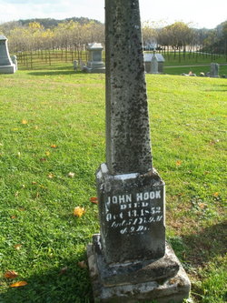
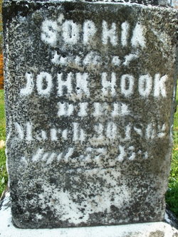
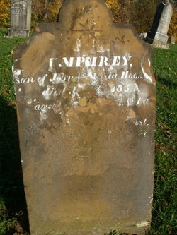
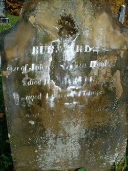
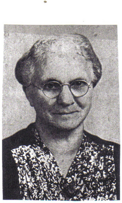
| Description | : | **Please note that the family newspaper article has a typo in it stating that Samuel came with his parents from Germany, when in fact he was born in Ohio. His birth record states Ohio as his birth location, parents John Hook and Sophia (Darling) Hook, as well as census records and his death record and our family Bible. Please keep in mind that newspaper obituaries can have a multitude of errors and family stories that have been handed down. FATHER;JOHN HOOK- SPOUSE;UNICE BROWN CHILDREN; 1.THOMAS-SPOUSE;HANNAH PENROD 2.ELMER-SPOUSE;SARAH CURLER 3.JOHN-SPOUSE;EMMA CURLER 4.EDWIN 5.SAMUEL-SPOUSE;FRANCES... Read More |
frequently asked questions (FAQ):
-
Where is Samuel Hook's memorial?
Samuel Hook's memorial is located at: St. Leonard's Churchyard, Padiham, Burnley Borough, England.
-
When did Samuel Hook death?
Samuel Hook death on 16 Oct 1924 in Elk Township, Clayton County, Iowa, USA
-
Where are the coordinates of the Samuel Hook's memorial?
Latitude: 53.8022600
Longitude: -2.3164300
Family Members:
Parent
Spouse

Siblings
Children
Flowers:


Nearby Cemetories:
1. St. Leonard's Churchyard
Padiham, Burnley Borough, England
Coordinate: 53.8022600, -2.3164300
2. Wesleyan Methodist Chapel Chapelyard
Padiham, Burnley Borough, England
Coordinate: 53.8018980, -2.3181730
3. St Leonard Churchyard Extension
Padiham, Burnley Borough, England
Coordinate: 53.7991800, -2.3222000
4. St. John's Cemetery
Padiham, Burnley Borough, England
Coordinate: 53.7948720, -2.3145290
5. All Saints Churchyard
Habergham Eaves, Burnley Borough, England
Coordinate: 53.7971060, -2.2913770
6. St James Church
Altham, Hyndburn Borough, England
Coordinate: 53.7928940, -2.3465250
7. St Margaret Churchyard
Hapton, Burnley Borough, England
Coordinate: 53.7802400, -2.3169230
8. St. John's Churchyard
Read, Ribble Valley Borough, England
Coordinate: 53.8088800, -2.3585600
9. St John Churchyard
Higham, Pendle Borough, England
Coordinate: 53.8251420, -2.2898120
10. Burnley Cemetery
Burnley, Burnley Borough, England
Coordinate: 53.7821730, -2.2795070
11. Burnley Crematorium
Burnley, Burnley Borough, England
Coordinate: 53.7821730, -2.2795070
12. Saint Nicholas Parish Churchyard
Sabden, Ribble Valley Borough, England
Coordinate: 53.8346503, -2.3332764
13. Holy Trinity Churchyard
Burnley, Burnley Borough, England
Coordinate: 53.7898290, -2.2574200
14. St Marys Burial Ground
Clayton-le-Moors, Hyndburn Borough, England
Coordinate: 53.7792778, -2.3705871
15. St. Anne Churchyard
Fence, Pendle Borough, England
Coordinate: 53.8304372, -2.2679552
16. St. James' Churchyard
Burnley, Burnley Borough, England
Coordinate: 53.7905590, -2.2458280
17. Accrington Cemetery and Crematorium
Accrington, Hyndburn Borough, England
Coordinate: 53.7623787, -2.3508649
18. Ebenezer Baptist Chapel Chapelyard
Burnley, Burnley Borough, England
Coordinate: 53.7975120, -2.2397260
19. Wheatley Lane Methodist Churchyard
Fence, Pendle Borough, England
Coordinate: 53.8341457, -2.2596202
20. St. Peter's Churchyard
Burnley, Burnley Borough, England
Coordinate: 53.7924450, -2.2394890
21. Barnes Square Weslyan Methodist Churchyard
Clayton-le-Moors, Hyndburn Borough, England
Coordinate: 53.7744350, -2.3853800
22. All Saints Churchyard
Clayton-le-Moors, Hyndburn Borough, England
Coordinate: 53.7738520, -2.3881690
23. Our Lady and Saint Hubert
Great Harwood, Hyndburn Borough, England
Coordinate: 53.7851070, -2.4009760
24. St. Bartholomew's Churchyard
Great Harwood, Hyndburn Borough, England
Coordinate: 53.7900670, -2.4055460