
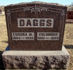
Andrew Jackson Daggs
| Birth | : | 4 Jun 1820 Kanawha County, West Virginia, USA |
| Death | : | 17 Sep 1878 Scotland County, Missouri, USA |
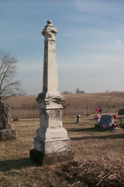
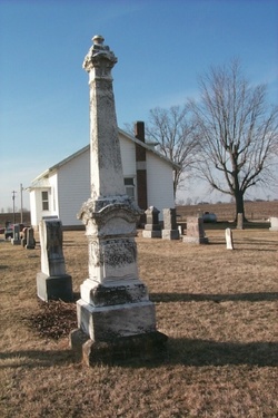
| Burial | : | Mount Pleasant Baptist Cemetery, Sandy Mush, Rutherford County, USA |
| Coordinate | : | 35.3026220, -81.8395470 |
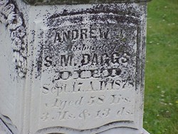
| Inscription | : | Andrew J. Husband of S. M. Daggs Died Sept 17, 1878 Aged 58 yrs. 3 Ms 13 ds |
| Description | : | A native of Virginia. He began as a poor man and became a man of considerable property in Scotland County, Missouri. His wife, Sarah M. Arnold a native of Kentucky, became the mother of eight children, of whom our subject is the third. The parents were Ruel and Nancy (Frazier) Daggs natives of West Virginia, and among the early settlers of Clark County, Mo. Photo taken by Alan Daggs on Jul 19, 1999 |
frequently asked questions (FAQ):
-
Where is Andrew Jackson Daggs's memorial?
Andrew Jackson Daggs's memorial is located at: Mount Pleasant Baptist Cemetery, Sandy Mush, Rutherford County, USA.
-
When did Andrew Jackson Daggs death?
Andrew Jackson Daggs death on 17 Sep 1878 in Scotland County, Missouri, USA
-
Where are the coordinates of the Andrew Jackson Daggs's memorial?
Latitude: 35.3026220
Longitude: -81.8395470
Family Members:
Parent
Spouse
Siblings

Children
Flowers:


Nearby Cemetories:
1. Mount Pleasant Baptist Cemetery
Sandy Mush, Rutherford County, USA
Coordinate: 35.3026220, -81.8395470
2. Morrow Curve Cemetery
Alexander Mills, Rutherford County, USA
Coordinate: 35.3007300, -81.8490800
3. Alexander Mills Cemetery
Alexander Mills, Rutherford County, USA
Coordinate: 35.3059100, -81.8566200
4. Morrow Cemetery
Forest City, Rutherford County, USA
Coordinate: 35.3216800, -81.8361000
5. Baxter Family Cemetery
Caroleen, Rutherford County, USA
Coordinate: 35.3028590, -81.8087310
6. Trout Family Cemetery
Sandy Mush, Rutherford County, USA
Coordinate: 35.2762150, -81.8428660
7. New Bethel Independent Church Cemetery
Forest City, Rutherford County, USA
Coordinate: 35.2802970, -81.8657590
8. New Bethel AME Zion Cemetery
Forest City, Rutherford County, USA
Coordinate: 35.2816470, -81.8682090
9. M&T Ministries Cemetery
Forest City, Rutherford County, USA
Coordinate: 35.3324970, -81.8517900
10. Doggett Grove AME Zion Cemetery
Forest City, Rutherford County, USA
Coordinate: 35.2808050, -81.8686810
11. Joshua Baptist Cemetery
Bostic, Rutherford County, USA
Coordinate: 35.3331750, -81.8260650
12. Doggett Cemetery
Forest City, Rutherford County, USA
Coordinate: 35.2932710, -81.8780670
13. Sisk Memorial Missionary Methodist Church Cemetery
Ellenboro, Rutherford County, USA
Coordinate: 35.3278710, -81.8077240
14. McDonald Family Cemetery
Forest City, Rutherford County, USA
Coordinate: 35.3075850, -81.8876240
15. Glenwood Baptist Cemetery
Bostic, Rutherford County, USA
Coordinate: 35.3422700, -81.8374700
16. Providence United Methodist Church Cemetery
Forest City, Rutherford County, USA
Coordinate: 35.2633018, -81.8305969
17. Oak Grove Missionary Baptist Church
Forest City, Rutherford County, USA
Coordinate: 35.3296300, -81.8782300
18. Victory Baptist Church Cemetery
Ellenboro, Rutherford County, USA
Coordinate: 35.3042000, -81.7884980
19. Oak Grove United Methodist Church Cemetery
Ellenboro, Rutherford County, USA
Coordinate: 35.3131840, -81.7884070
20. Bethany Baptist Church Cemetery
Forest City, Rutherford County, USA
Coordinate: 35.3029200, -81.8933260
21. Cool Springs Cemetery
Forest City, Rutherford County, USA
Coordinate: 35.3396988, -81.8711014
22. Saint Luke F.B.H. Church Cemetery
Forest City, Rutherford County, USA
Coordinate: 35.3405390, -81.8697340
23. Bostic Baptist Cemetery
Bostic, Rutherford County, USA
Coordinate: 35.3489370, -81.8371580
24. Caroleen Avondale Henrietta Cemetery
Avondale, Rutherford County, USA
Coordinate: 35.2753940, -81.7925690