
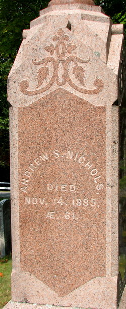
Andrew Symonds Nichols
| Birth | : | 1824 |
| Death | : | 14 Nov 1855 |
| Burial | : | Coopers Gap Baptist Church Cemetery, Mill Spring, Polk County, USA |
| Coordinate | : | 35.3786030, -82.1986630 |
| Plot | : | C538 |
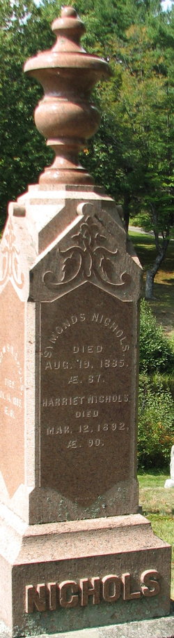
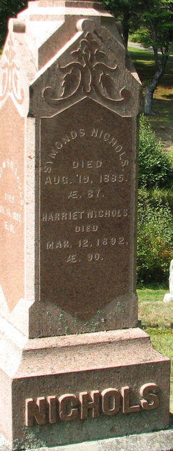
| Description | : | He removed to California in the early days of gold mining there, and made that state his home. Parents: Symonds Nichols and Harriet Gregg Unmarried Source: The History of New Ipswich, N.H. 1735-1914, Charles Henry Chandler,page 531,532. |
frequently asked questions (FAQ):
-
Where is Andrew Symonds Nichols's memorial?
Andrew Symonds Nichols's memorial is located at: Coopers Gap Baptist Church Cemetery, Mill Spring, Polk County, USA.
-
When did Andrew Symonds Nichols death?
Andrew Symonds Nichols death on 14 Nov 1855 in
-
Where are the coordinates of the Andrew Symonds Nichols's memorial?
Latitude: 35.3786030
Longitude: -82.1986630
Family Members:
Parent
Siblings

Flowers:


Nearby Cemetories:
1. Coopers Gap Baptist Church Cemetery
Mill Spring, Polk County, USA
Coordinate: 35.3786030, -82.1986630
2. McGuinn Burying Ground
Mill Spring, Polk County, USA
Coordinate: 35.3941157, -82.1944560
3. Laughter Family Cemetery
Mill Spring, Polk County, USA
Coordinate: 35.3992130, -82.1977540
4. Victory in Jesus Baptist Church Cemetery
Mill Spring, Polk County, USA
Coordinate: 35.3573120, -82.1833700
5. Cane Creek Missionary Baptist Church Cemetery
Lake Lure, Rutherford County, USA
Coordinate: 35.4090340, -82.1950920
6. Son RIse Old TIme Gospel Church Cemetery
Mill Spring, Polk County, USA
Coordinate: 35.4040300, -82.1723580
7. Grassy Knob Church Cemetery
Lake Lure, Rutherford County, USA
Coordinate: 35.4087500, -82.1723090
8. Mountain View Baptist Church Cemetery
Mill Spring, Polk County, USA
Coordinate: 35.3533530, -82.2353240
9. Big Level Baptist Church Cemetery
Mill Spring, Polk County, USA
Coordinate: 35.3632060, -82.1509230
10. Weaver Cemetery
Lake Lure, Rutherford County, USA
Coordinate: 35.4294587, -82.2047271
11. Temple of Jesus Cemetery
Lake Lure, Rutherford County, USA
Coordinate: 35.4255508, -82.1639378
12. Rock Springs Baptist Church Cemetery
Rutherfordton, Rutherford County, USA
Coordinate: 35.3970520, -82.1287280
13. Silver Creek Baptist Church Cemetery
Mill Spring, Polk County, USA
Coordinate: 35.3209460, -82.2270300
14. Chimney Rock Baptist Church Cemetery
Lake Lure, Rutherford County, USA
Coordinate: 35.4382380, -82.2301020
15. Early Cemetery
Mill Spring, Polk County, USA
Coordinate: 35.3278821, -82.2504389
16. Whiteside Family Cemetery
Uree, Rutherford County, USA
Coordinate: 35.4234390, -82.1384470
17. Lebanon Methodist Church Cemetery
Mill Spring, Polk County, USA
Coordinate: 35.3532710, -82.1189030
18. Faith Temple Baptist Church Cemetery
Mill Spring, Polk County, USA
Coordinate: 35.3227044, -82.1468833
19. Jackson at Bright's Creek Cemetery
Polk County, USA
Coordinate: 35.3317700, -82.2672800
20. Mountain Home Baptist Church Cemetery
Edneyville, Henderson County, USA
Coordinate: 35.3950745, -82.2884417
21. Collins Cemetery
Edneyville, Henderson County, USA
Coordinate: 35.4082280, -82.2849970
22. Flynn Cemetery
Bills Creek, Rutherford County, USA
Coordinate: 35.4530640, -82.1729440
23. Arledge Cemetery
Mill Spring, Polk County, USA
Coordinate: 35.3154550, -82.2534460
24. Bagwell Cemetery
Lake Lure, Rutherford County, USA
Coordinate: 35.4542730, -82.1719410